
File:Hazel.gif
此為最大尺寸。
Hazel.gif (304 × 272 像素,檔案大小:30 KB,MIME 類型:image/gif、0.2秒)
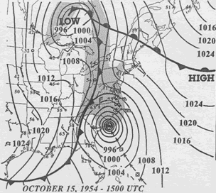
| 描述 | 15 UTC map of October 1954 showing Hurricane Hazel and the meteorological set-up. | |||
| 日期 | ||||
| 來源 | NOAA analysis created by Paul Kocin, of NOAA’s National Weather Service. It can be found at Environment Canada and at NOAA pages. This map is included in this article about Hazel by the Canadian Hurricane Center and this one by the National Weather Service Eastern Region Headquarters. | |||
| 作者 | NOAA | |||
| 授權許可 (重用此檔案) |
|
檔案歷史
點選日期/時間以檢視該時間的檔案版本。
| 日期/時間 | 縮圖 | 尺寸 | 使用者 | 備註 | |
|---|---|---|---|---|---|
| 目前 | 2010年3月13日 (六) 16:32 | | 304 × 272(30 KB) | Maxim | removed border |
| 2007年4月2日 (一) 07:23 |  | 312 × 277(32 KB) | Pierre cb | {{Hurricane auto track map|type=Hurricane|name=Hazel (1954)|source=NHC}} H {{Information |Description= 15 UTC map of October 1954 showing Hurricane Hazel and the meteorological set-up. |Source= [http://www.atl.e |
檔案用途
下列頁面有用到此檔案:
全域檔案使用狀況
以下其他 wiki 使用了這個檔案:
- en.wikipedia.org 的使用狀況
- eo.wikipedia.org 的使用狀況
- es.wikipedia.org 的使用狀況
- fa.wikipedia.org 的使用狀況
- fr.wikipedia.org 的使用狀況
- pt.wikipedia.org 的使用狀況