
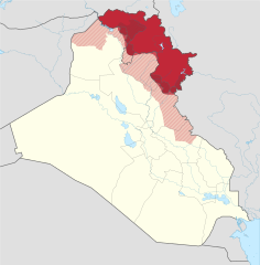
File:Iraqi Kurdistan in Iraq (de-facto and disputed hatched).svg

此 SVG 檔案的 PNG 預覽的大小:589 × 600 像素。 其他解析度:236 × 240 像素 | 471 × 480 像素 | 754 × 768 像素 | 1,005 × 1,024 像素 | 2,011 × 2,048 像素 | 1,241 × 1,264 像素。
原始檔案 (SVG 檔案,表面大小:1,241 × 1,264 像素,檔案大小:545 KB)
摘要
.svg)
.svg)
.svg)
.svg)
.svg)
.svg)
.svg)

-en.svg)

.svg)
.svg)
.svg)

_(US48).svg)
_(small_islands_magnified)_(-mini_map_-rivers).svg)
.svg)
_(extra_close)_(US48).svg)
.svg)
_(zoom).svg)

.svg)


_(UNMIK).svg)
.svg)
_(disputed_hatched).svg)
_(claimed_and_disputed_hatched).svg)
.svg)
.svg)
_(%2Ball_claims_hatched).svg)

.svg)
_(shade).svg)
_(shade)_(special_marker).svg)
_(-mini_map).svg)
_(-mini_map).svg)
_(-mini_map).svg)


.svg)

.svg)
.svg?uselang=zh-tw)
.svg?uselang=zh-tw)
.svg?action=history&uselang=zh-tw)
.svg)
授權條款
此檔案採用創用CC 姓名標示-相同方式分享 3.0 未在地化版本授權條款。
- 您可以自由:
- 分享 – 複製、發佈和傳播本作品
- 重新修改 – 創作演繹作品
- 惟需遵照下列條件:
- 姓名標示 – 您必須指名出正確的製作者,和提供授權條款的連結,以及表示是否有對內容上做出變更。您可以用任何合理的方式來行動,但不得以任何方式表明授權條款是對您許可或是由您所使用。
- 相同方式分享 – 如果您利用本素材進行再混合、轉換或創作,您必須基於如同原先的相同或兼容的條款,來分布您的貢獻成品。
References
Official territory and governorate borders
- http://www.krso.net/Default.aspx?page=article&id=1142
- http://www.economist.com/images/20070908/CMA980.gif
Claimed territory
- http://www.aina.org/reports/pcok.pdf (page 13)
- http://www.economist.com/images/20070908/CMA980.gif
- http://photos1.blogger.com/blogger/6564/131/1600/Kurdistan_july05_claimed-767346.jpg
- http://images.fastcompany.com/magazine/144/feature-84-Kurdistan-OilMap-pop.jpg
- http://news.bbcimg.co.uk/media/images/76876000/gif/_76876578_iraq_kurdistan_624.gif
檔案歷史
點選日期/時間以檢視該時間的檔案版本。
.svg&variant=zh-tw&dir=prev)
.svg&variant=zh-tw&offset=20170928132057)
.svg&variant=zh-tw&offset=&limit=20)
.svg&variant=zh-tw&offset=&limit=50)
.svg&variant=zh-tw&offset=&limit=100)
.svg&variant=zh-tw&offset=&limit=250)
.svg&variant=zh-tw&offset=&limit=500)
| 日期/時間 | 縮圖 | 尺寸 | 使用者 | 備註 | |
|---|---|---|---|---|---|
| 目前 | 2018年7月19日 (四) 23:01 | | 1,241 × 1,264(545 KB) | Rob984 | dashed official KRG border on the basis that it's disputed by Baghdad. |
| 2018年7月19日 (四) 19:05 |  | 1,241 × 1,264(548 KB) | Rob984 | Also Iraqi forces took Khanaqin in October as well | |
| 2018年7月19日 (四) 18:12 |  | 1,241 × 1,264(549 KB) | Rob984 | The town of Makhmur was taken over by Iraqi forces last year. Also the frontier in Kirkuk likely corresponds to the 2003 green line, not the administrative border, since Iraq only requested the Kurdish forces withdraw to the green line. | |
| 2018年1月26日 (五) 22:34 |  | 1,241 × 1,264(549 KB) | 0ali1 | Update 26/01/2018, minor fixes | |
| 2017年10月24日 (二) 23:55 |  | 1,241 × 1,264(549 KB) | Rob984 | Federal government has reassumed control over most (if not all) of the Kirkuk province. | |
| 2017年10月24日 (二) 16:03 |  | 1,241 × 1,264(549 KB) | Rob984 | Scaled back changes around Machmur. Peshmerga have not withdrawn from the town, despite earlier reports suggesting so. | |
| 2017年10月20日 (五) 12:26 |  | 1,241 × 1,264(549 KB) | Rob984 | Update following Peshmerga withdrawal from a number of areas. Note Kurdish militias (eg PKK, YBS, etc.) have not withdrew from all areas, but they are not under KRG control. Approximate area, will need to be updated. | |
| 2017年10月12日 (四) 20:20 |  | 1,241 × 1,264(555 KB) | Spesh531 | Update now that ISIS is no longer on the Iraqi Kurdish-Iraqi proper border | |
| 2017年9月28日 (四) 14:28 |  | 1,241 × 1,264(555 KB) | Rob984 | another minor fix | |
| 2017年9月28日 (四) 13:20 |  | 1,241 × 1,264(555 KB) | Rob984 | minor fix |
檔案用途
下列5個頁面有用到此檔案:
全域檔案使用狀況
以下其他 wiki 使用了這個檔案:
- als.wikipedia.org 的使用狀況
- ar.wikipedia.org 的使用狀況
- arz.wikipedia.org 的使用狀況
- azb.wikipedia.org 的使用狀況
- az.wikipedia.org 的使用狀況
- ba.wikipedia.org 的使用狀況
- bcl.wikipedia.org 的使用狀況
- be-tarask.wikipedia.org 的使用狀況
- be.wikipedia.org 的使用狀況
- bg.wikipedia.org 的使用狀況
- bn.wikipedia.org 的使用狀況
- br.wikipedia.org 的使用狀況
- bs.wikipedia.org 的使用狀況
- ceb.wikipedia.org 的使用狀況
- ckb.wikipedia.org 的使用狀況
- cs.wikipedia.org 的使用狀況
- cy.wikipedia.org 的使用狀況
- da.wikipedia.org 的使用狀況
- de.wikipedia.org 的使用狀況
- diq.wikipedia.org 的使用狀況
- el.wikipedia.org 的使用狀況
- el.wikivoyage.org 的使用狀況
- en.wikipedia.org 的使用狀況
- Iraqi Kurdistan
- Minorities in Iraq
- 2008 Turkish incursion into northern Iraq
- List of active separatist movements in Asia
- Disputed territories of northern Iraq
- Northern Iraq offensive (June 2014)
- Talk:Iraqi Kurdistan/Archive 2
- Ba'athist Arabization campaigns in northern Iraq
- COVID-19 pandemic in the Kurdistan Region
- eo.wikipedia.org 的使用狀況
- es.wikipedia.org 的使用狀況
檢視此檔案的更多全域使用狀況。
.svg)
.svg)