
File:Midway Atoll map.svg

此 SVG 檔案的 PNG 預覽的大小:365 × 392 像素。 其他解析度:223 × 240 像素 | 447 × 480 像素 | 715 × 768 像素 | 953 × 1,024 像素 | 1,907 × 2,048 像素。
原始檔案 (SVG 檔案,表面大小:365 × 392 像素,檔案大小:37 KB)
| 描述 |
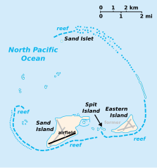
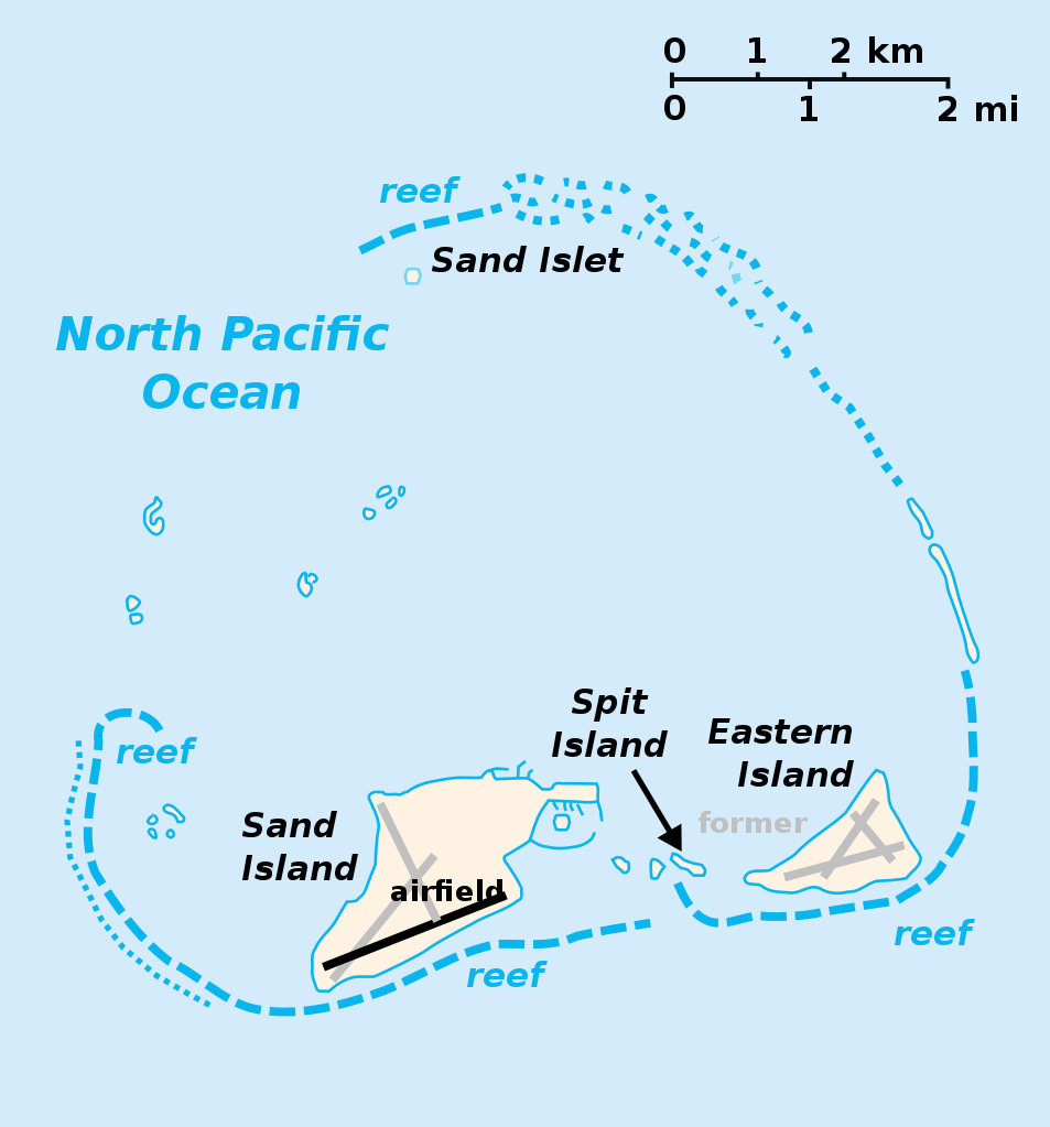
English: Midway Atoll with Sand Island, Spit Island and Eastern Island. Abandoned runways of Henderson Field in gray. |
| 日期 | |
| 來源 | |
| 作者 |
|
| 其他版本 | File:Midway Atoll map ja.png, Macedonian version |
| 這是一張修飾過的圖片,即本圖片是用軟體修改過後的版本,修改的方式或內容有:color abandoned runways。原版圖片來源:Midway Islands-CIA WFB Map.png。修改者:Gooney birds。
|
此檔案採用創用CC 姓名標示-相同方式分享 3.0 未在地化版本授權條款。
- 您可以自由:
- 分享 – 複製、發佈和傳播本作品
- 重新修改 – 創作演繹作品
- 惟需遵照下列條件:
- 姓名標示 – 您必須指名出正確的製作者,和提供授權條款的連結,以及表示是否有對內容上做出變更。您可以用任何合理的方式來行動,但不得以任何方式表明授權條款是對您許可或是由您所使用。
- 相同方式分享 – 如果您利用本素材進行再混合、轉換或創作,您必須基於如同原先的相同或兼容的條款,來分布您的貢獻成品。
原始上傳日誌
This image is a derivative work of the following images:
- File:Midway_Islands.svg licensed with PD-self
- 2007-03-26T00:20:33Z Indolences 365x392 (37683 Bytes) cleaning up code
- 2007-02-12T00:24:07Z Indolences 365x392 (44729 Bytes)
- 2007-02-12T00:22:48Z Indolences 365x392 (45062 Bytes) {{Information |Description= the Midway Islands |Source= self made from CIA maps (PD) |Date= 11/2/07 |Author= [[User:Indolences]] |Permission={{PD-self}} |other_versions= }} [[Category:Midway Island]]
- File:Midway_Islands-CIA_WFB_Map.png licensed with PD-USGov-CIA-WF
- 2006-08-13T13:17:15Z Augiasstallputzer~commonswiki 365x392 (17785 Bytes)
- 2005-03-27T09:16:29Z Wolfman 365x392 (8752 Bytes) {{CIA-map}}
Uploaded with derivativeFX
檔案歷史
點選日期/時間以檢視該時間的檔案版本。
| 日期/時間 | 縮圖 | 尺寸 | 使用者 | 備註 | |
|---|---|---|---|---|---|
| 目前 | 2009年11月16日 (一) 03:33 | | 365 × 392(37 KB) | Gooney birds | {{Information |Description={{en|Midway Atoll with Sand Island, Spit Island and Eastern Island. Abandoned runways of Henderson Field in gray.}} |Source= *File:Midway_Islands-CIA_WFB_Map.png |
檔案用途
沒有使用此檔案的頁面。
全域檔案使用狀況
以下其他 wiki 使用了這個檔案:
- af.wikipedia.org 的使用狀況
- als.wikipedia.org 的使用狀況
- arz.wikipedia.org 的使用狀況
- ast.wikipedia.org 的使用狀況
- az.wikipedia.org 的使用狀況
- bg.wikipedia.org 的使用狀況
- br.wikipedia.org 的使用狀況
- bs.wikipedia.org 的使用狀況
- ceb.wikipedia.org 的使用狀況
- ce.wikipedia.org 的使用狀況
- cs.wikipedia.org 的使用狀況
- da.wikipedia.org 的使用狀況
- de.wikipedia.org 的使用狀況
- en.wikipedia.org 的使用狀況
- eo.wikipedia.org 的使用狀況
- es.wikipedia.org 的使用狀況
- eu.wikipedia.org 的使用狀況
- fa.wikipedia.org 的使用狀況
- fi.wikipedia.org 的使用狀況
- fo.wikipedia.org 的使用狀況
- frp.wikipedia.org 的使用狀況
- fr.wikipedia.org 的使用狀況
- fr.wiktionary.org 的使用狀況
- gcr.wikipedia.org 的使用狀況
- hr.wikipedia.org 的使用狀況
- hu.wikipedia.org 的使用狀況
- io.wikipedia.org 的使用狀況
- it.wikipedia.org 的使用狀況
- ja.wikipedia.org 的使用狀況
- ka.wikipedia.org 的使用狀況
- ko.wikipedia.org 的使用狀況
- ky.wikipedia.org 的使用狀況
- lij.wikipedia.org 的使用狀況
- li.wikipedia.org 的使用狀況
- lt.wikipedia.org 的使用狀況
- nl.wikipedia.org 的使用狀況
- pl.wikipedia.org 的使用狀況
- pt.wikipedia.org 的使用狀況
- ro.wikipedia.org 的使用狀況
- ru.wikipedia.org 的使用狀況
- sh.wikipedia.org 的使用狀況
檢視此檔案的更多全域使用狀況。