
File:Nordkapp map.png
預覽大小:800 × 509 像素。 其他解析度:320 × 204 像素 | 640 × 408 像素 | 837 × 533 像素。
原始檔案 (837 × 533 像素,檔案大小:400 KB,MIME 類型:image/png)
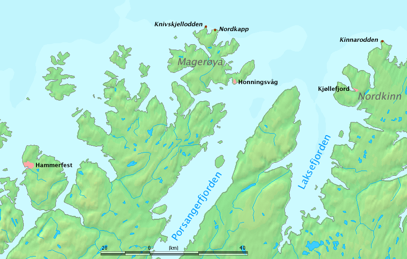
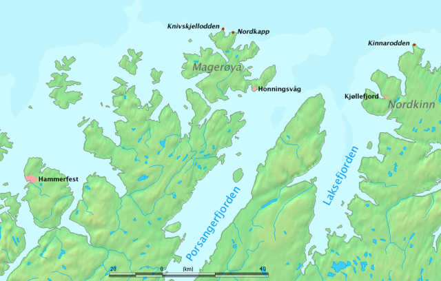
Map of North Cape region, Norway.
The map shows Nordkapp, Kinnarodden (northernmost point of mainland Europe, located on Nordkinn peninsula) and Knivskjellodden (northernmost point of Europe, located on the island of Magerøya).
Work by Markus Bernet, background map courtesy of www.demis.nl[失效連結].
This image is in the public domain because it came from the site https://www.demis.nl/products/web-map-server/examples/ and was released by the copyright holder. Permission is granted to copy, distribute and/or modify this map since it is based on free of copyright images from: www.demis.nl. See also approval email on de.wp and its clarification.
|
| This work has been released into the public domain by its copyright holder, www.demis.nl. This applies worldwide. 這可能在某些國家不合法,如果是的話: www.demis.nl授予任何人有權利使用此作品於任何用途,除受法律約束外,不受任何限制。
|
檔案歷史
點選日期/時間以檢視該時間的檔案版本。
| 日期/時間 | 縮圖 | 尺寸 | 使用者 | 備註 | |
|---|---|---|---|---|---|
| 目前 | 2006年3月26日 (日) 11:45 | | 837 × 533(400 KB) | MRB | Map of North Cape region, Norway. The map shows '''Nordkapp''', '''Kinnarodden''' (northernmost point of ''mainland'' Europe, located on Nordkinn peninsula) and '''Knivskjellodden''' (northernmost point of Europe, located on the island of Magerøya). W |
檔案用途
全域檔案使用狀況
以下其他 wiki 使用了這個檔案:
- az.wikipedia.org 的使用狀況
- bg.wikipedia.org 的使用狀況
- cy.wikipedia.org 的使用狀況
- da.wikipedia.org 的使用狀況
- de.wikipedia.org 的使用狀況
- de.wiktionary.org 的使用狀況
- el.wikipedia.org 的使用狀況
- en.wikipedia.org 的使用狀況
- es.wikipedia.org 的使用狀況
- et.wikipedia.org 的使用狀況
- fa.wikipedia.org 的使用狀況
- fi.wikipedia.org 的使用狀況
- fr.wikipedia.org 的使用狀況
- fy.wikipedia.org 的使用狀況
- gl.wikipedia.org 的使用狀況
- he.wikipedia.org 的使用狀況
- hr.wikipedia.org 的使用狀況
- hu.wikipedia.org 的使用狀況
- it.wikipedia.org 的使用狀況
- kw.wikipedia.org 的使用狀況
- nl.wikipedia.org 的使用狀況
檢視此檔案的更多全域使用狀況。