
File:Plan Centre Spatial Guyanais-en.svg

此 SVG 檔案的 PNG 預覽的大小:648 × 599 像素。 其他解析度:260 × 240 像素 | 519 × 480 像素 | 831 × 768 像素 | 1,108 × 1,024 像素 | 2,215 × 2,048 像素 | 1,060 × 980 像素。
原始檔案 (SVG 檔案,表面大小:1,060 × 980 像素,檔案大小:472 KB)

|
This SVG file contains embedded text that can be translated into your language, using any capable SVG editor, text editor or the SVG Translate tool. For more information see: About translating SVG files. |
摘要
| 描述 |
[]
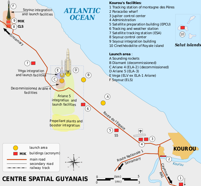
Català: Mapa de la infraestructura dels llançadors Ariane i Vega al port espacial europeu (Centre Spatial Guyanais o CSG), Kourou, Guaiana Francesa Deutsch: Karte der Infrastruktur der Ariana- und Vega-Startrampen auf dem Weltraumbahnhof Kourou, Französisch-Guayana English: Map of the infrastructure for the Ariane and Vega launchers at the Europe's Spaceport (Centre Spatial Guyanais or CSG) , Kourou, French Guiana Français : Carte des installations du Centre Spatial Guyanais (CSG) de Kourou, Guyane Francaise (France) Magyar: A Guyanai Űrközpont térképe Nederlands: Kaart van de Europese lanceerbasis (Centre Spatial Guyanais of CSG) in Kourou, Frans Guiana Русский: План космодрома «Куру» во Французской Гвиане |
||
| 日期 | |||
| 來源 | 自己的作品 | ||
| 作者 | Pline | ||
| 其他版本 |
[]
|


授權條款
我,本作品的著作權持有者,決定用以下授權條款發佈本作品:

|
已授權您依據自由軟體基金會發行的無固定段落、封面文字和封底文字GNU自由文件授權條款1.2版或任意後續版本,對本檔進行複製、傳播和/或修改。該協議的副本列在GNU自由文件授權條款中。 |
您可以選擇您需要的授權條款。
檔案歷史
點選日期/時間以檢視該時間的檔案版本。
| 日期/時間 | 縮圖 | 尺寸 | 使用者 | 備註 | |
|---|---|---|---|---|---|
| 目前 | 2016年3月4日 (五) 18:08 | | 1,060 × 980(472 KB) | Manlleus | Sorry again! |
| 2016年3月4日 (五) 18:06 |  | 1,060 × 980(524 KB) | Manlleus | Reverted to version as of 13:37, 13 April 2009 (UTC) - Sorry, was a big error! | |
| 2016年2月1日 (一) 20:51 |  | 1,060 × 980(524 KB) | Manlleus | Editing SVG source code using User:Rillke/SVGedit.js; upload handled by User:Rillke/MwJSBot.js | |
| 2009年4月13日 (一) 13:37 |  | 1,060 × 980(524 KB) | Pline | {{Information |Description={{en|1=Map of the infrastructure for the Ariane and Vega launchers at the Europe's Spaceport (Centre Spatial Guyanais or CSG) , Kourou, French Guiana}} {{fr|1=Carte des installations du Centre Spatial Guyanais (CSG) de Kourou, G |
檔案用途
下列頁面有用到此檔案:
全域檔案使用狀況
以下其他 wiki 使用了這個檔案:
- el.wikipedia.org 的使用狀況
- en.wikipedia.org 的使用狀況
- eo.wikipedia.org 的使用狀況
- es.wikipedia.org 的使用狀況
- et.wikipedia.org 的使用狀況
- fi.wikipedia.org 的使用狀況
- he.wikipedia.org 的使用狀況
- id.wikipedia.org 的使用狀況
- it.wikipedia.org 的使用狀況
- ja.wikipedia.org 的使用狀況
- kn.wikipedia.org 的使用狀況
- lv.wikipedia.org 的使用狀況
- ms.wikipedia.org 的使用狀況
- no.wikipedia.org 的使用狀況
- ro.wikipedia.org 的使用狀況
- sk.wikipedia.org 的使用狀況
- sl.wikipedia.org 的使用狀況
- sr.wikipedia.org 的使用狀況
- uk.wikipedia.org 的使用狀況
- vi.wikipedia.org 的使用狀況