
File:Qinghai lake.jpg

原始檔案 (640 × 640 像素,檔案大小:138 KB,MIME 類型:image/jpeg)
摘要
| 描述 |
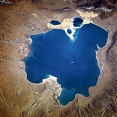
Deutsch: Qinghai-See, China - November 1994
English: Qinghai Lake, China - also, originally known as Koko Nor in Mongolian and Tso Ngonpo in Tibetan - November 1994
Español: Lago Qinghai, China - Noviembre 1994
中文:青海湖 |
|||||
| 日期 | 攝於1994年11月8日, 04:13:36 GMT | |||||
| 來源 |
https://eol.jsc.nasa.gov/sseop/EFS/photoinfo.pl?PHOTO=STS066-118-23 https://eol.jsc.nasa.gov/SearchPhotos/photo.pl?mission=STS066&roll=118&frame=23 |
|||||
| 作者 | NASA | |||||
| 授權許可 (重用此檔案) |
|
|||||
| NASA information |
|

| 拍攝地點 | | 位於此地的本圖片與其他圖片: OpenStreetMap |
|---|
本圖像或影音收錄於美國國家航空暨太空總署 (NASA)某部門,其照片編號為: STS066-118-23 此標籤不表示文件的著作權狀態。任何文件在附有此標籤的同時還需要一個有效的著作權標籤。請參閱許可協議說明頁面以了解更多資訊。 其他語言:
|
檔案歷史
點選日期/時間以檢視該時間的檔案版本。
| 日期/時間 | 縮圖 | 尺寸 | 使用者 | 備註 | |
|---|---|---|---|---|---|
| 目前 | 2005年10月10日 (一) 15:02 | | 640 × 640(138 KB) | Immanuel Giel | Qinghai Lake, China - November 1994 '''Source''': from the English Wikipedia<br> image description [http://eol.jsc.nasa.gov/sseop/EFS/photoinfo.pl?PHOTO=STS066-118-23 here] en:Qinghai Lake {{PD-USGov-NASA}} |
檔案用途
下列61個頁面有用到此檔案:
- 中华人民共和国国际重要湿地列表
- 四海
- 立方千米
- 青海湖
- Talk:2021年玛多地震
- Talk:2022年门源地震
- Talk:2022年青海山洪
- Talk:三十里铺墓地
- Talk:三江源
- Talk:中国格萨尔文化博物馆
- Talk:云塔村
- Talk:京藏高速公路
- Talk:各拉丹冬峰
- Talk:塔尔寺
- Talk:天峻县
- Talk:宏善寺
- Talk:康家语
- Talk:德令哈市
- Talk:拉布尔城
- Talk:敦格铁路
- Talk:景阳什家祠堂照壁、家庙照壁
- Talk:曼宗曲
- Talk:杨小民案
- Talk:杰桑·索南达杰
- Talk:洛桑 (1942年)
- Talk:湟中区
- Talk:满坪镇
- Talk:王家寺
- Talk:现任青海省地级行政区行政长官列表
- Talk:甘德格萨尔文化博物馆
- Talk:生格乡 (天峻县)
- Talk:电灌站墓地
- Talk:盐湖股份
- Talk:索加乡
- Talk:羌隆沟墓地
- Talk:茶卡盐湖
- Talk:西宁东关清真寺
- Talk:西宁市
- Talk:西宁曹家堡国际机场
- Talk:西滩遗址
- Talk:贵德县
- Talk:赛什腾山
- Talk:青海二二三事件
- Talk:青海河流列表
- Talk:青海湖
- Talk:青海省
- Talk:青海省文物保护单位
- Talk:青海省民俗博物馆
- Talk:青海高速公路
- Talk:青藏高原
- Talk:骆惠宁
- Talk:龙脖脖遗址
- User talk:地底深山
- Template:青海专题
- Template talk:Location map China Qinghai
- Template talk:Qinghai topics
- Template talk:中華民國青海省行政區劃
- Template talk:青海省道
- Template talk:青海行政区划
- Category talk:台灣戰後青海移民
- Category talk:青海清真寺
全域檔案使用狀況
以下其他 wiki 使用了這個檔案:
- ace.wikipedia.org 的使用狀況
- ar.wikipedia.org 的使用狀況
- ast.wikipedia.org 的使用狀況
- az.wikipedia.org 的使用狀況
- ba.wikipedia.org 的使用狀況
- be.wikipedia.org 的使用狀況
- bg.wikipedia.org 的使用狀況
- bn.wikipedia.org 的使用狀況
- bo.wikipedia.org 的使用狀況
- br.wikipedia.org 的使用狀況
- ca.wikipedia.org 的使用狀況
- cdo.wikipedia.org 的使用狀況
- ceb.wikipedia.org 的使用狀況
- cs.wikipedia.org 的使用狀況
- cv.wikipedia.org 的使用狀況
- da.wikipedia.org 的使用狀況
- de.wikipedia.org 的使用狀況
- el.wikipedia.org 的使用狀況
- en.wikipedia.org 的使用狀況
- en.wikivoyage.org 的使用狀況
- eo.wikipedia.org 的使用狀況
檢視此檔案的更多全域使用狀況。