
File:SaintPierre1780.png

預覽大小:800 × 464 像素。 其他解析度:320 × 186 像素 | 640 × 371 像素 | 869 × 504 像素。
原始檔案 (869 × 504 像素,檔案大小:828 KB,MIME 類型:image/png)
摘要
| 描述 |
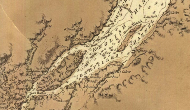
English: This is a detail from the source map, showing locations important in the March 1776 Battle of Saint-Pierre. The source map is captioned as follows: General chart of Gulph and River St. Lawrence |
|||
| 日期 | ||||
| 來源 |
URL at time of upload: http://services.banq.qc.ca/sdx/cep/document.xsp?app=ca.BAnQ.sdx.cep&db=notice&id=0002663541&n=13&sortfield=date_publication&col=america&v=saint-laurent_(fleuve)%23%23%23Saint-Laurent+(Fleuve)&order=ascendant&f=lieu_nav&chpp=20&dbrqp=query_notice&qid=sdx_q3 |
|||
| 作者 | Des Barres, Joseph F.W, (Joseph Frederick Wallet), 1722- 1824 |

授權條款
|
本作品在其來源國以及其他著作權期限是作者逝世後100年或以下的國家與地區屬於公有領域。 | |
| 此作品無已知的著作權限制,亦不受所有相關和鄰接的權利限制。 | |
檔案歷史
點選日期/時間以檢視該時間的檔案版本。
| 日期/時間 | 縮圖 | 尺寸 | 使用者 | 備註 | |
|---|---|---|---|---|---|
| 目前 | 2009年2月13日 (五) 02:12 | | 869 × 504(828 KB) | Magicpiano | {{Information |Description={{en|1=This is a detail from the source map, showing locations important in the March 1776 Battle of Saint-Pierre. The source map is captioned as follows: General chart of Gulph and River St. Lawren |
檔案用途
下列頁面有用到此檔案:
全域檔案使用狀況
以下其他 wiki 使用了這個檔案:
- en.wikipedia.org 的使用狀況
- fr.wikipedia.org 的使用狀況
- it.wikipedia.org 的使用狀況
- ja.wikipedia.org 的使用狀況
- nl.wikipedia.org 的使用狀況
- www.wikidata.org 的使用狀況