
File:Satellite image of Flevopolder, Netherlands (5.48E 52.43N).png

預覽大小:800 × 548 像素。 其他解析度:320 × 219 像素 | 640 × 439 像素 | 1,024 × 702 像素。
原始檔案 (1,024 × 702 像素,檔案大小:1.49 MB,MIME 類型:image/png)
.png?uselang=zh-tw)
.png?uselang=zh-tw)
.png?action=history&uselang=zh-tw)
.png)
| 描述 |
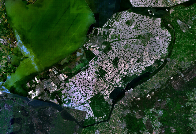
English: Satellite image of the Flevopolder in the Netherlands. Technically, the Flevopolder consists of Zuidelijk Flevoland (Southern Flevoland), Oostelijk Flevoland (Eastern Flevoland) and the Noordoostpolder (North Eastern Polder). This image shows Southern and Eastern Flevoland. |
| 來源 | Screenshot from NASA's World Wind |
| 作者 | 相片: NASA |
| 本圖像屬於公有領域,因其為NASA的World Wind衛星地圖瀏覽器的一張截圖,且使用了公有領域圖層,如Blue Marble、MODIS、Landsat、SRTM、USGS、GLOBE等。
|
 |
檔案歷史
點選日期/時間以檢視該時間的檔案版本。
| 日期/時間 | 縮圖 | 尺寸 | 使用者 | 備註 | |
|---|---|---|---|---|---|
| 目前 | 2005年5月4日 (三) 13:25 | | 1,024 × 702(1.49 MB) | Galwaygirl | Satellite image of the Flevopolder in the Netherlands. Screenshot from NASA's World Wind {{PD}} |
檔案用途
下列3個頁面有用到此檔案:
全域檔案使用狀況
以下其他 wiki 使用了這個檔案:
- an.wikipedia.org 的使用狀況
- ar.wikipedia.org 的使用狀況
- ast.wikipedia.org 的使用狀況
- br.wikipedia.org 的使用狀況
- ca.wikipedia.org 的使用狀況
- cs.wikipedia.org 的使用狀況
- da.wikipedia.org 的使用狀況
- de.wikipedia.org 的使用狀況
- el.wikipedia.org 的使用狀況
- en.wikipedia.org 的使用狀況
- es.wikipedia.org 的使用狀況
- eu.wikipedia.org 的使用狀況
- fa.wikipedia.org 的使用狀況
- fr.wikipedia.org 的使用狀況
- gl.wikipedia.org 的使用狀況
- he.wikipedia.org 的使用狀況
- hr.wikipedia.org 的使用狀況
- hy.wikipedia.org 的使用狀況
- id.wikipedia.org 的使用狀況
- kk.wikipedia.org 的使用狀況
- ko.wikipedia.org 的使用狀況
- ms.wikipedia.org 的使用狀況
- nl.wikipedia.org 的使用狀況
- no.wikipedia.org 的使用狀況
- oc.wikipedia.org 的使用狀況
- ro.wikipedia.org 的使用狀況
- ru.wikipedia.org 的使用狀況
- sh.wikipedia.org 的使用狀況
- simple.wikipedia.org 的使用狀況
檢視此檔案的更多全域使用狀況。
.png)
.png)