
File:Thames Estuary and Wind Farms from Space NASA with annotations.jpg

預覽大小:750 × 600 像素。 其他解析度:300 × 240 像素 | 600 × 480 像素 | 960 × 768 像素 | 1,280 × 1,024 像素 | 2,560 × 2,048 像素 | 5,000 × 4,000 像素。
原始檔案 (5,000 × 4,000 像素,檔案大小:3.74 MB,MIME 類型:image/jpeg)
摘要
| 描述 |
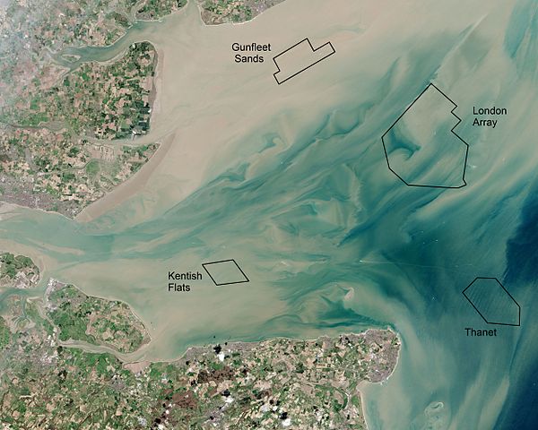
English: Thames Estuary and Wind Farms from Space NASA. Windfarms visible in the image are: London Array, Thanet Wind Farm, Kentish Flats Wind Farm and Gunfleet Sands Wind Farm. Kentish Flats is pictured before its 2015 extension was constructed. |
| 日期 | |
| 來源 | Annotated version of File:Thames Estuary and Wind Farms from Space NASA.jpg showing offshore wind farms |
| 作者 | Operational Land Imager, with annotations by Delusion23 |
| 其他版本 |
 (no annotations) |
| 拍攝地點 | | 位於此地的本圖片與其他圖片: OpenStreetMap |
|---|
授權條款
| 本作品由NASA創作,屬於公有領域。根據NASA的版權政策:“NASA的創作除非另有聲明否則不受版權保護。”(參見:Template:PD-USGov/zh,NASA版權政策或JPL圖像使用政策) | ||
 |
警告:
|
| 註解 | 該圖片含有註解:在維基媒體共享資源上查看註解 |
檔案歷史
點選日期/時間以檢視該時間的檔案版本。
| 日期/時間 | 縮圖 | 尺寸 | 使用者 | 備註 | |
|---|---|---|---|---|---|
| 目前 | 2015年6月22日 (一) 21:23 | | 5,000 × 4,000(3.74 MB) | Delusion23 | User created page with UploadWizard |
檔案用途
全域檔案使用狀況
以下其他 wiki 使用了這個檔案:
- en.wikipedia.org 的使用狀況
- fr.wikipedia.org 的使用狀況
- ig.wikipedia.org 的使用狀況
- it.wikipedia.org 的使用狀況
- ja.wikipedia.org 的使用狀況
- nl.wikipedia.org 的使用狀況
- ru.wikipedia.org 的使用狀況
- sv.wikipedia.org 的使用狀況
- vi.wikipedia.org 的使用狀況