
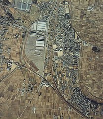
File:貨物輸送現役時の北野桝塚駅航空写真.jpg

本预览的尺寸:522 × 599像素。 其他分辨率:209 × 240像素 | 418 × 480像素 | 669 × 768像素 | 892 × 1,024像素 | 2,087 × 2,396像素。
原始文件 (2,087 × 2,396像素,文件大小:1.36 MB,MIME类型:image/jpeg)
摘要
| 物体位置 | | 在以下服务上查看本图像和附近其他图像: OpenStreetMap |
|---|
许可协议

|
本文件的著作权人,Ministry of Land, Infrastructure, Transport and Tourism,允许任何人在适当地表明著作权人的姓名的前提下,以任何目的使用本文件。传播,演绎作品,商业用途及所有其他用途被允许。 |
署名:
National Land Image Information (Color Aerial Photographs), created by Ministry of Land, Infrastructure, Transport and Tourism, distributed by Geospatial Information Authority of Japan
|

![[1]](http://w3land.mlit.go.jp/Air/photo400/82/ccb-82-3/c6e/ccb-82-3_c6e_31.jpg)
文件历史
点击某个日期/时间查看对应时刻的文件。
| 日期/时间 | 缩略图 | 大小 | 用户 | 备注 | |
|---|---|---|---|---|---|
| 当前 | 2013年11月24日 (日) 13:37 | | 2,087 × 2,396(1.36 MB) | 要塞騎士 | User created page with UploadWizard |
文件用途
以下页面使用本文件: