
File:Balkan Fires, Earth from Aqua (EOS PM-1) (2007-07-25).jpg

原始文件 (4,800 × 6,200像素,文件大小:4.33 MB,MIME类型:image/jpeg)
|

本图像被选为2007年11月2日的今日图片。其说明如下: English: Satellite picture shows the fires in Balkan Peninsula on July 25, 2007. 其他语言:
Asturianu: Imaxen de satélite amosando los incendios na Península de los Balcanes (25 xunetu 2007) Čeština: satelitní snímek požárů v Řecku z 25. července 2007 Deutsch: Satellitenbild der Waldbrände in Griechenland vom 25. Juli 2007. Eesti: Satelliidifoto metsatulekahjudest Kreekas 25. juulist 2007. English: Satellite picture shows the fires in Balkan Peninsula on July 25, 2007. Español: Imagen de satélite mostrando los incendios en la Península Balcánica el 25 de julio de 2007. Français : Prise de vue depuis un satellite des incendies du 25 juillet 2007 dans la péninsule des Balkans. Lietuvių: Palydovinis paveikslėlis rodantis gaisrus Balkanų pusiasalyje 2007 liepos 25 d. Magyar: Műholdfelvétel a Balkán-félszigetről. A kis piros pöttyök a keletkezett erdőtüzeket jelölik, a nagyobbak füstje hosszan elnyúlik. (NASA Aqua (EOS PM-1) műhold, 2007. július 25.) Polski: Satelitarne zdjęcie z 25 lipca 2007 pokazujące pożary na Półwyspie Bałkańskim. Português: Imagem de satélite exibindo incêndios na Península dos Bálcãs. Slovenčina: Satelitný snímok požiaru na Balkánskom polostrove z 25. júla 2007. Slovenščina: Satelitska slika prikazuje požare 25. julija 2007 na Balkanskem polotoku Русский: Лесные пожары на Балканском полуострове. Вид из космоса. Српски / srpski: Сателитска слика која приказује пожаре на полуострву Балкана 25. јула 2007. године. ქართული: 2007 წლის ივლისში ბალკანეთის ნახევარკუნძულზე ხანძრების სატელიტური სურათი. 한국어: 발칸 반도의 화재를 보여주는 위성 사진, 2007년 7월 25일. 日本語: バルカン半島の森林火災の様子。衛星写真、2007年7月25日。 中文: 显示2007年7月25日巴尔干半岛森林大火的卫星照片。 中文(繁體): 2007年7月25日巴爾幹半島森林大火的衛星照片 العربية : صورة بالقمر الصناعي تبيّن نار في شبه الجزيرة البلقانية في يوليو/تموز 25 ، 2007. |
摘要
| 描述 |
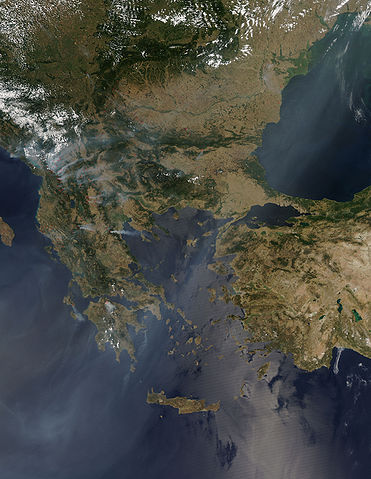
English: Image of the Balkan Peninsula captured by the MODIS on the Aqua satellite in July 25, 2007, and showing many fires dotting the landscape of Southern Europe.
The fires, represented by red dots, pumped out thick plumes of smoke that blanketed the region with haze. A thin white-gray pall of smoke hangs over the Ionian Sea southwest of Greece, and additional smoke covers the Black Sea in the northeast. The Aegean Sea to the east of Greece likely also had smoke-filled skies, but sunlight reflecting off the surface of the water masks the haze from view in this image. The fires caused a state of emergency in Macedonia, and Greece put its northern forests under constant watch fearing further fire outbreaks, reported BBC News on July 25. The fires were fueled by extreme, desiccating heat starting in mid-July. Super-hot air pushed north from Africa and settled over much of southeastern Europe, where temperatures climbed above 40 degrees Celsius (104 Fahrenheit). As many 500 died in the heat in Hungary (north of the area shown here), and the high demand for power caused black-outs in Greece, Kosovo, and Montenegro, said the BBC. On the following month, even stronger fires outbroke in the Peloponese peninsula.Français : Image satellite prise le 25 juillet 2007 par la caméra MODIS du satellite Aqua pour la NASA. Cette image couvre la péninsule des Balkans et montre les nombreux feux de forêts présents ce jour là en Europe du sud.
Les feux, indiqué en rouge, ont émis de grosses quantités de fumée qui a recouvert la région d'une brume. Une fine couche gris blanchâtre de fumée est visible au dessus de la mer ionienne au sud-ouest de la Grèce, ainsi que la mer noire au nord-est. La mer Égée, à l'est de la Grèce, est probablement elle aussi recouverte par ce voile de fumée, mais il est rendu invisible sur cette image par le reflet du soleil sur l'eau. Les feux, qui causèrent l'instauration de l'état d'urgence en Macédoine et dans le nord de la Grèce, furent causés par une vague de chaleur apparue à la mi-juillet. De l'air surchauffé venant d'Afrique s'est installé dans le sud-est de l'Europe, causant une montée des températures au dessus de 40°C. Cette vague de chaleur à causé la mort de 500 personnes en Hongrie et des pannes de courant due à la forte demande d'électricité pour les systèmes de climatisation en Grèce, au Kosovo et dans le Montenegro (Source BBC). Le mois suivant, des feux encore plus important allaisent dévaster la Grèce, particulièrement dans la péninsule du Péloponnèse.
|
|||||
| 日期 | 摄于2007年7月25日 | |||||
| 来源 | http://modis.gsfc.nasa.gov/gallery/individual.php?db_date=2007-07-28 direct link | |||||
| 作者 | NASA's Aqua (EOS PM-1) satellite (Jeff Schmaltz, MODIS Land Rapid Response Team, NASA GSFC) | |||||
| 授权 (二次使用本文件) |
|

_(2007-07-25).jpg?uselang=zh)
_(2007-07-25).jpg?uselang=zh)
_(2007-07-25).jpg?action=history&uselang=zh)
_(2007-07-25).jpg)
_(2007-07-25).jpg)
_(2007-07-25).jpg)
文件历史
点击某个日期/时间查看对应时刻的文件。
| 日期/时间 | 缩略图 | 大小 | 用户 | 备注 | |
|---|---|---|---|---|---|
| 当前 | 2007年8月27日 (一) 09:03 | | 4,800 × 6,200(4.33 MB) | とある白い猫 | == Summary == {{Information |Description=Several days, ago, we had an image of fires in southern Europe from July 22, 2007. Today's image is from July 25, 2007, and it shows the many fires that still dot the landscape of Southern Europe. This image, captu |
文件用途
以下2个页面使用本文件:
全域文件用途
以下其他wiki使用此文件:
- ar.wikipedia.org上的用途
- ba.wikipedia.org上的用途
- bn.wikipedia.org上的用途
- bn.wikibooks.org上的用途
- cv.wikipedia.org上的用途
- de.wikipedia.org上的用途
- en.wikipedia.org上的用途
- fa.wikibooks.org上的用途
- fr.wikipedia.org上的用途
- hu.wikipedia.org上的用途
- hy.wikibooks.org上的用途
- kk.wikipedia.org上的用途
- ko.wikipedia.org上的用途
- lbe.wikipedia.org上的用途
- oc.wikipedia.org上的用途
- os.wikipedia.org上的用途
- pl.wikipedia.org上的用途
- pt.wikipedia.org上的用途
- ru.wikipedia.org上的用途
- ru.wikinews.org上的用途
- sv.wikipedia.org上的用途
- tr.wikipedia.org上的用途
- Balkanlar
- Vikipedi:Seçkin resimler/Uzay/Dünya'ya bakış
- Orman yangını
- Kullanıcı:BIYIKLI
- Portal:Türkiye/Seçilen resim
- Vikipedi:Seçkin resim adayları/Arşiv/Mart 2008
- Vikipedi:Seçkin resim adayları/Balkan Fires, Earth from Aqua (EOS PM-1) (2007-07-25).jpg
- Vikipedi:Seçkin resimler/Ana sayfaya çıkmış resimler/2009 listesi
- Vikipedi:Günün seçkin resmi/Temmuz 2009
- Şablon:GSR/2009-07-10
- Vikiproje:Balkanlar
- Vikiproje:Balkanlar/Proje Girişi
- Kullanıcı mesaj:とある白い猫/Archive/2008
- Kullanıcı mesaj:とある白い猫/Archive/2008/03
- Kullanıcı mesaj:MD/Arşiv 1
- Vikipedi:Seçkin resimler/Ana sayfaya çıkmış resimler/2015 listesi
- Vikipedi:Günün seçkin resmi/Temmuz 2015
- Şablon:GSR/2015-07-01
- Aqua (uydu)
- Vikipedi:Günün seçkin resmi/Eylül 2022
- Şablon:GSR/2022-09-27
- uk.wikipedia.org上的用途
_(2007-07-25).jpg)
查看本文件的更多全域用途。
_(2007-07-25).jpg)
_(2007-07-25).jpg)