
File:Balkhash labeled eng.jpg

本预览的尺寸:800 × 449像素。 其他分辨率:320 × 180像素 | 640 × 359像素 | 1,024 × 575像素 | 1,280 × 719像素 | 2,036 × 1,143像素。
原始文件 (2,036 × 1,143像素,文件大小:686 KB,MIME类型:image/jpeg)
| 描述 |
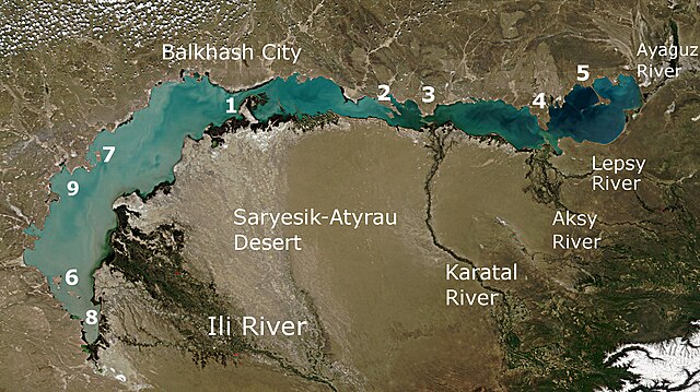
English: Lake Balkhash and the surrounding area viewed from space Русский: Озеро Балхаш и окружающая местность, вид из космоса |
| 日期 | (UTC) |
| 来源 | |
| 作者 |
|
- Saryesik peninsula, separating the lake into two parts, and the Strait Uzynaral
- Baygabyl Peninsula
- Balai Peninsula
- Shaukar Peninsula
- Kentubek Peninsula
- Islands Basaran and Ortaaral
- Tasaral Island
- Shempek Bay
- Saryshagan Bay
| 本文件完全由NASA创作,在美国属于公有领域。根据NASA的版权方针,NASA的材料除非另有声明否则不受版权保护。(参见Template:PD-USGov/zh、NASA版权方针页面或JPL图片使用方针。) | ||
 |
警告:
|
原始上传日志
This image is a derivative work of the following images:
- File:Lake_Balkhash_satellite.jpg licensed with PD-USGov-NASA
- 2009-01-26T19:00:08Z Monfornot 3000x2300 (1231868 Bytes) {{Information |Description={{en|1=Lake Balkhash and the surrounding area viewed from space}} {{ru|1=Озеро Балхаш и окружающая местность, вид из космоса}} |Source=http://visibleearth.
Uploaded with derivativeFX
文件历史
点击某个日期/时间查看对应时刻的文件。
| 日期/时间 | 缩略图 | 大小 | 用户 | 备注 | |
|---|---|---|---|---|---|
| 当前 | 2014年5月6日 (二) 05:43 | | 2,036 × 1,143(686 KB) | Materialscientist | Relabeled per File:Balkhash labeled ru.jpg |
| 2010年5月24日 (一) 06:42 |  | 2,036 × 1,143(594 KB) | Materialscientist | {{Information |Description={{en|1=Lake Balkhash and the surrounding area viewed from space}} {{ru|1=Озеро Балхаш и окружающая местность, вид из космоса}} |Source=*File:Lake_Balkhash_satellite.jpg |Date=2010 |
文件用途
全域文件用途
以下其他wiki使用此文件:
- af.wikipedia.org上的用途
- arz.wikipedia.org上的用途
- ast.wikipedia.org上的用途
- bg.wikipedia.org上的用途
- bn.wikipedia.org上的用途
- ca.wikipedia.org上的用途
- de.wikipedia.org上的用途
- de.wikivoyage.org上的用途
- en.wikipedia.org上的用途
- es.wikipedia.org上的用途
- fa.wikipedia.org上的用途
- gl.wikipedia.org上的用途
- he.wikipedia.org上的用途
- hi.wikipedia.org上的用途
- hu.wikipedia.org上的用途
- hy.wikipedia.org上的用途
- id.wikipedia.org上的用途
- it.wikipedia.org上的用途
- ja.wikipedia.org上的用途
- ka.wikipedia.org上的用途
- kn.wikipedia.org上的用途
- lt.wikipedia.org上的用途
- mt.wikipedia.org上的用途
- pnb.wikipedia.org上的用途
- tr.wikipedia.org上的用途
- uk.wikipedia.org上的用途
- uz.wikipedia.org上的用途
- www.wikidata.org上的用途