
File:CVG airport diagram.svg

此SVG文件的PNG预览的大小:378 × 548像素。 其他分辨率:165 × 240像素 | 331 × 480像素 | 530 × 768像素 | 706 × 1,024像素 | 1,413 × 2,048像素。
原始文件 (SVG文件,尺寸为378 × 548像素,文件大小:1.08 MB)
摘要
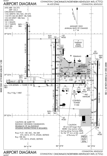
| 描述 | FAA diagram of Cincinnati/Northern Kentucky International Airport. |
| 日期 | Diagram is dated November 23, 2006–December 31, 2006 |
| 来源 | Found via NACO site. Converted from this PDF to SVG using this method. |
| 作者 | en:FAA |
| 授权 (二次使用本文件) |
Public domain |
许可协议
|
|
 |
文件历史
点击某个日期/时间查看对应时刻的文件。
| 日期/时间 | 缩略图 | 大小 | 用户 | 备注 | |
|---|---|---|---|---|---|
| 当前 | 2007年1月5日 (五) 15:27 | | 378 × 548(1.08 MB) | Grendelkhan | {{Information |Description=FAA diagram of Cincinnati/Northern Kentucky International Airport. |Source=Found via [http://gc.kls2.com/airport/CVG Great Circle Mapper]. Converted from [http://www.naco.faa.gov/d-tpp/0612/00655AD.PDF this PDF] to SVG using [[: |
文件用途
以下页面使用本文件:
全域文件用途
以下其他wiki使用此文件:
- de.wikipedia.org上的用途
- fr.wikipedia.org上的用途
- it.wikipedia.org上的用途
- ja.wikipedia.org上的用途
- pl.wikipedia.org上的用途
- pt.wikipedia.org上的用途
- ru.wikipedia.org上的用途
- vi.wikipedia.org上的用途