
File:Candor Chasma region of Valles Marineris, Mars.jpg

原始文件 (516 × 740像素,文件大小:128 KB,MIME类型:image/jpeg)
摘要
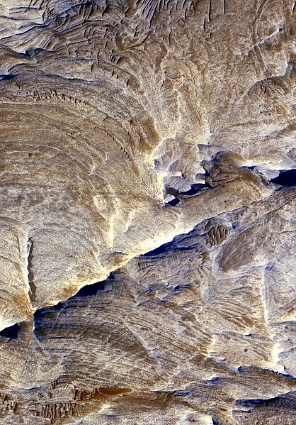
Image: Ridges as Evidence of Fluid Alteration on the Planet Mars. Tectonic fractures within the Candor Chasma region of Valles Marineris, Mars, retain ridge-like shapes as the surrounding bedrock erodes away. This points to past episodes of fluid alteration along the fractures and reveals clues into past fluid flow and geochemical conditions below the surface.
The High Resolution Imaging Science Experiment camera on NASA's Mars Reconnaissance Orbiter took this image on Dec. 2, 2006. The image is approximately 1 kilometer (0.6 mile) across. Illumination from the upper left.
This view is a portion of the camera's image catalogued as PSP_001641_1735.
NASA's Jet Propulsion Laboratory, a division of the California Institute of Technology in Pasadena, manages the Mars Reconnaissance Orbiter for NASA's Science Mission Directorate, Washington. Lockheed Martin Space Systems, Denver, is the prime contractor for the project and built the spacecraft. The High Resolution Imaging Science Experiment is operated by the University of Arizona, Tucson, and the instrument was built by Ball Aerospace and Technology Corp., Boulder, Colo.
Source: http://www.nasa.gov/mission_pages/MRO/multimedia/pia09189.html
许可协议
| 本文件完全由NASA创作,在美国属于公有领域。根据NASA的版权方针,NASA的材料除非另有声明否则不受版权保护。(参见Template:PD-USGov/zh、NASA版权方针页面或JPL图片使用方针。) | ||
 |
警告:
|
文件历史
点击某个日期/时间查看对应时刻的文件。
| 日期/时间 | 缩略图 | 大小 | 用户 | 备注 | |
|---|---|---|---|---|---|
| 当前 | 2007年2月17日 (六) 21:03 | | 516 × 740(128 KB) | DragonFire1024 | '''Image:''' Ridges as Evidence of Fluid Alteration on the Planet Mars. Tectonic fractures within the Candor Chasma region of Valles Marineris, Mars, retain ridge-like shapes as the surrounding bedrock erodes away. This points to past episodes of fluid al |
文件用途
以下页面使用本文件:
全域文件用途
以下其他wiki使用此文件:
- en.wikipedia.org上的用途
- en.wikinews.org上的用途
- ja.wikipedia.org上的用途
- ms.wikipedia.org上的用途
- pt.wikipedia.org上的用途
- uk.wikipedia.org上的用途
- ur.wikipedia.org上的用途