
File:Countries by immigrant population.svg

此SVG文件的PNG预览的大小:800 × 410像素。 其他分辨率:320 × 164像素 | 640 × 328像素 | 1,024 × 525像素 | 1,280 × 657像素 | 2,560 × 1,313像素 | 1,035 × 531像素。
原始文件 (SVG文件,尺寸为1,035 × 531像素,文件大小:1.47 MB)
摘要
| 描述 |
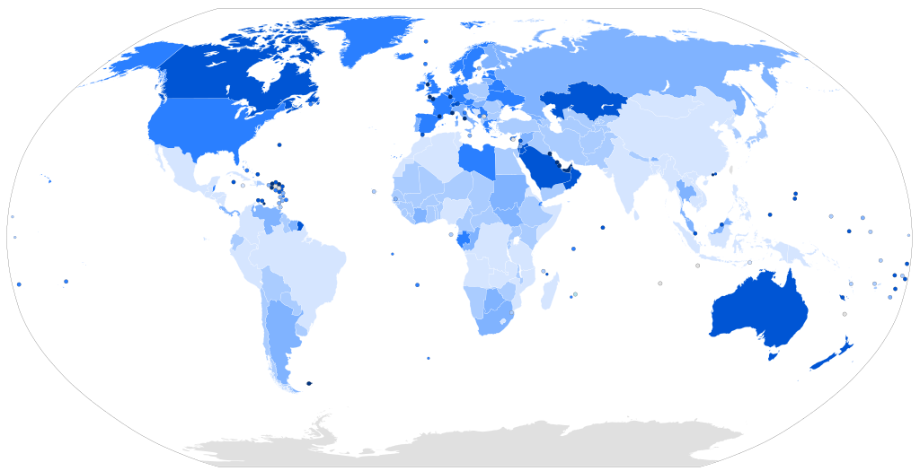
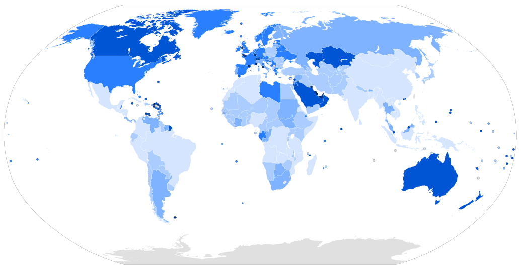
Map of the world with countries coloured according to their immigrant population as a percentage of the whole population, based on the UN's World Population Policies 2005 data ([1]). Legend: more than 50% 20% to 50% 10% to 20% 4% to 10% 1% to 4% less than 1% |
| 日期 | |
| 来源 | Own work, derived from Image:BlankMap-World6.svg |
| 作者 | Thebainer (Stephen Bain) |
| 其他版本 |
此文件衍生的作品: Map of countries by percentage of immigrants.png File:Countries by immigrant population.png, raster version |
| SVG开发 |
许可协议
| I, Stephen Bain, hereby publish this work under the following licences: | ||
You may select the licence of your choice. |

文件历史
点击某个日期/时间查看对应时刻的文件。
| 日期/时间 | 缩略图 | 大小 | 用户 | 备注 | |
|---|---|---|---|---|---|
| 当前 | 2017年3月16日 (四) 07:15 | | 1,035 × 531(1.47 MB) | TriadicRelation98 | Updated for 2015 |
| 2007年3月11日 (日) 12:44 |  | 940 × 477(2.26 MB) | Stephen Bain | ==Information== {{Information |Description=Map of the world with countries coloured according to their immigrant population as a percentage of the whole population, based on the UN's World Population Policies 2005 data ([http://www.u |
文件用途
以下页面使用本文件:
全域文件用途
以下其他wiki使用此文件:
- ar.wikipedia.org上的用途
- bg.wikipedia.org上的用途
- da.wikibooks.org上的用途
- de.wikipedia.org上的用途
- en.wikipedia.org上的用途
- fa.wikipedia.org上的用途
- fi.wikipedia.org上的用途
- hr.wikipedia.org上的用途
- hu.wikipedia.org上的用途
- id.wikipedia.org上的用途
- is.wikipedia.org上的用途
- it.wikipedia.org上的用途
- lt.wikipedia.org上的用途
- pl.wikipedia.org上的用途
- pnb.wikipedia.org上的用途
- pt.wikipedia.org上的用途
- ru.wikipedia.org上的用途
- sr.wikipedia.org上的用途
- sr.wikinews.org上的用途
- sv.wikipedia.org上的用途
- ta.wikipedia.org上的用途
- tr.wikipedia.org上的用途
- ur.wikipedia.org上的用途
- vec.wikipedia.org上的用途