
File:Europe 1740 en.png

本预览的尺寸:800 × 570像素。 其他分辨率:320 × 228像素 | 640 × 456像素 | 1,024 × 730像素 | 1,280 × 913像素 | 2,560 × 1,825像素 | 3,872 × 2,761像素。
原始文件 (3,872 × 2,761像素,文件大小:1.25 MB,MIME类型:image/png)
_en.png)
.png)
.jpg)
摘要
| 描述 |
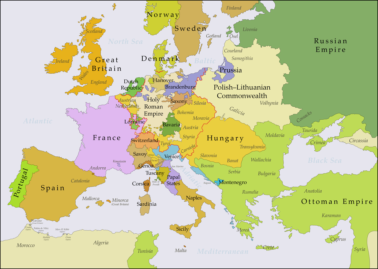
English: This map shows Europe in the years between the 1739 Treaty of Belgrade (the end of the Austro–Turkish War (1737–39)) and the beginning of the War of the Austrian Succession in 1740. The red line marks the borders of the Holy Roman Empire. The work was created with Inkscape and is mainly based on a map in: Putzger - Historischer Weltatlas, Berlin 1990, 78 pp. |
| 日期 | |
| 来源 | 自己的作品, based on File:Europe 1748-1766 en.png |
| 作者 | Bryan Rutherford |
许可协议
我,本作品著作权人,特此采用以下许可协议发表本作品:
本文件采用知识共享署名-相同方式共享 4.0 国际许可协议授权。
- 您可以自由地:
- 共享 – 复制、发行并传播本作品
- 修改 – 改编作品
- 惟须遵守下列条件:
- 署名 – 您必须对作品进行署名,提供授权条款的链接,并说明是否对原始内容进行了更改。您可以用任何合理的方式来署名,但不得以任何方式表明许可人认可您或您的使用。
- 相同方式共享 – 如果您再混合、转换或者基于本作品进行创作,您必须以与原先许可协议相同或相兼容的许可协议分发您贡献的作品。
文件历史
点击某个日期/时间查看对应时刻的文件。
| 日期/时间 | 缩略图 | 大小 | 用户 | 备注 | |
|---|---|---|---|---|---|
| 当前 | 2018年7月15日 (日) 21:49 | | 3,872 × 2,761(1.25 MB) | Bryanrutherford0 | Added the Ionian Islands, made the Duchy of Milan a Habsburg possession |
| 2018年7月10日 (二) 02:28 |  | 3,872 × 2,761(1.25 MB) | Bryanrutherford0 | Added Comtat Venaissin and redrew borders of Neuchâtel, Bishopric Basel, and Montbéliard | |
| 2017年10月3日 (二) 00:39 |  | 3,872 × 2,761(1.25 MB) | Bryanrutherford0 | Transferred control of Saaremaa and Hiiumaa to Russia (1721 Treaty of Nystad) | |
| 2017年8月24日 (四) 12:50 |  | 3,872 × 2,761(1.25 MB) | Bryanrutherford0 | Removed Prussian East Frisia (acquired 1744) | |
| 2017年8月23日 (三) 20:17 |  | 3,872 × 2,761(1.25 MB) | Bryanrutherford0 | User created page with UploadWizard |
文件用途
以下4个页面使用本文件:
全域文件用途
以下其他wiki使用此文件:
- azb.wikipedia.org上的用途
- bg.wikipedia.org上的用途
- ca.wikipedia.org上的用途
- cs.wikipedia.org上的用途
- de.wikipedia.org上的用途
- el.wikipedia.org上的用途
- en.wikipedia.org上的用途
- es.wikipedia.org上的用途
- fa.wikipedia.org上的用途
- fi.wikipedia.org上的用途
- fr.wikipedia.org上的用途
- gcr.wikipedia.org上的用途
- he.wikipedia.org上的用途
- id.wikipedia.org上的用途
- it.wikipedia.org上的用途
- ja.wikipedia.org上的用途
- lv.wikipedia.org上的用途
- pt.wikipedia.org上的用途
- ru.wikipedia.org上的用途
- sr.wikipedia.org上的用途