
File:Gambia satellite fires.jpeg
本预览的尺寸:800 × 242像素。 其他分辨率:320 × 97像素 | 1,432 × 433像素。
原始文件 (1,432 × 433像素,文件大小:103 KB,MIME类型:image/jpeg)
摘要
| 描述 |
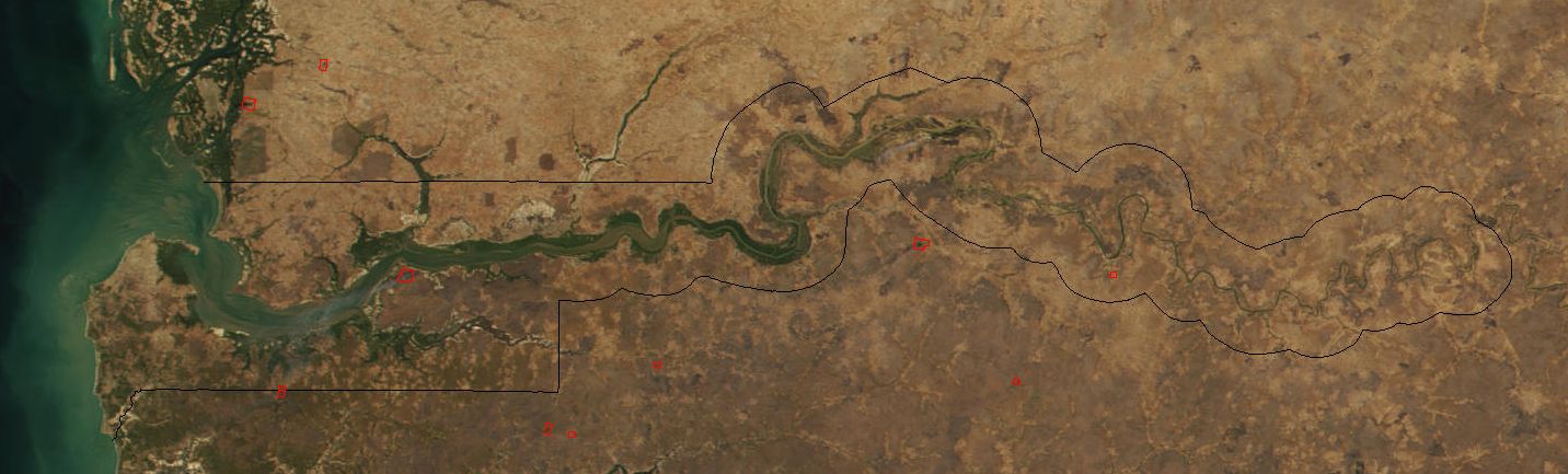
Image cropped to The Gambia. The red dots sprinkled all across this true-color image show the locations of fires mostly located in the African savannas just south of the Sahel region. Many fires were burning in this region throughout February 2002. This scene was acquired by the Moderate-resolution Imaging Spectroradiometer (MODIS), flying aboard NASA's Terra satellite, on Feb. 15. |
| 日期 | |
| 来源 | Cropped from: http://visibleearth.nasa.gov/view_rec.php?id=2521 |
| 作者 | Jacques Descloitres, MODIS Land Rapid Response Team at NASA GSFC |
| 其他版本 | Image:Senegal satellite fires.jpeg |
许可协议
| 本文件完全由NASA创作,在美国属于公有领域。根据NASA的版权方针,NASA的材料除非另有声明否则不受版权保护。(参见Template:PD-USGov/zh、NASA版权方针页面或JPL图片使用方针。) | ||
 |
警告:
|
文件历史
点击某个日期/时间查看对应时刻的文件。
| 日期/时间 | 缩略图 | 大小 | 用户 | 备注 | |
|---|---|---|---|---|---|
| 当前 | 2004年12月20日 (一) 18:11 | 1,432 × 433(103 KB) | Ikiwaner | Map from [http://visibleearth.nasa.gov/cgi-bin/viewrecord?12145 NASA Visible Earth] {{PD-USGov-NASA}} |
文件用途
以下页面使用本文件:
全域文件用途
以下其他wiki使用此文件:
- af.wikipedia.org上的用途
- ar.wikipedia.org上的用途
- ca.wikipedia.org上的用途
- cs.wikipedia.org上的用途
- cv.wikipedia.org上的用途
- da.wikipedia.org上的用途
- de.wikipedia.org上的用途
- en.wikipedia.org上的用途
- eo.wikipedia.org上的用途
- es.wikipedia.org上的用途
- fi.wikipedia.org上的用途
- frr.wikipedia.org上的用途
- fr.wikipedia.org上的用途
- ha.wikipedia.org上的用途
- he.wikipedia.org上的用途
- ja.wikipedia.org上的用途
- jv.wikipedia.org上的用途
- mk.wikipedia.org上的用途
- ms.wikipedia.org上的用途
- nl.wikipedia.org上的用途
- nn.wikipedia.org上的用途
- pt.wikipedia.org上的用途
- ru.wikipedia.org上的用途
- sv.wikipedia.org上的用途
- sw.wikipedia.org上的用途
- uk.wikipedia.org上的用途
- vi.wikipedia.org上的用途
- wo.wikipedia.org上的用途
- xmf.wikipedia.org上的用途