
File:Istočna Slavonija, Baranja i Zapadni Srem-en.png

本预览的尺寸:411 × 599像素。 其他分辨率:164 × 240像素 | 329 × 480像素 | 881 × 1,285像素。
原始文件 (881 × 1,285像素,文件大小:92 KB,MIME类型:image/png)
摘要
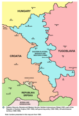
- English: Map of the Eastern Slavonia, Baranja and Western Syrmia, which was Serbian Autonomous Oblast (1991), part of the Republic of Serbian Krajina (1991-1995), self-governing entity (1995-1996), and UN-administered territory (1996-1998). Borders presented in this map are from 1994.
- Srpskohrvatski: Mapa područja Istočne Slavonije, Baranje i Zapadnog Srema, koje je bilo Srpska autonomna oblast (1991), deo Republike Srpske Krajine (1991-1995), samoupravni entitet (1995-1996) i teritorija pod upravom UN-a (1996-1998). Granice predstavljene na ovoj mapi su iz 1994. godine.
Source and licence
Map was created by en:user:PANONIAN and was originally uploaded into English Wikipedia. It was moved to Wikimedia Commons by User:Amadalvarez. User:Amadalvarez is not author of this map.
| 我,本作品著作权人,释出本作品至公有领域。这适用于全世界。 在一些国家这可能不合法;如果是这样的话,那么: 我无条件地授予任何人以任何目的使用本作品的权利,除非这些条件是法律规定所必需的。 |
References
- Sve srpske mape - od šestog veka do Pariza, Specijalno izdanje BLICA, Decembar 1995. godine.
- Dr Tomislav Bogavac, Nestajanje Srba, Niš, 1994.
- Miodrag Milošević, Geografija za 8. razred osnovne škole, Beograd, 1994.
- Dragan Rodić, Geografija za I ili III razred srednje škole, Beograd, 1995.
- Istorijski atlas, Geokarta, Beograd, 1999.
- Richard Overy, The Times History of the 20th Century, Times Books, London, 2004.
- The Times History of Europe, Times Books, London, 2002.
- Slavko Vejinović, Srbi u dijaspori u prošlosti i sadašnjosti, Novi Sad, 1999.
- Tim Džuda, Srbi - istorija, mit i razaranje Jugoslavije, Beograd, 2003.
- Džon R. Lempi, Jugoslavija kao istorija, Beograd, 2004.
- Nada Miletić Stanić, Pravoslavne crkve u Baranji, Novi Sad, 1999.
- http://web.ku.edu/~eceurope/hist557/lect20_files/yugoslavprovinces.jpg archive copy at the Wayback Machine
- http://terkepek.adatbank.transindex.ro/kepek/netre/292.gif
- http://www.pointernet.pds.hu/touristinfo/croatia/image/g.jpg archive copy at the Wayback Machine
- http://clip2net.com/clip/m6499/1217833413-krajina_army_territorial_division-jpg-34kb.jpg
- http://profile.ak.fbcdn.net/hprofile-ak-snc4/50514_294052851171_2302284_n.jpg archive copy at the Wayback Machine
- http://www.vecernji.hr/slika-500x329/vijesti/otkrivamo-britanci-trazili-da-baranju-dio-istocne-slavonije-predamo-srbiji-slika-85519[失效链接]
- http://www.srpskapolitika.com/krajina/mapa211.jpg archive copy at the Wayback Machine
- http://www.srpska-mreza.com/MAPS/Ethnic-groups/map-UN-1994.jpg
- http://www.srpskapolitika.com/krajina/etnicka_karta.jpg archive copy at the Wayback Machine
- http://www.srpskapolitika.com/krajina/mapa311.jpg archive copy at the Wayback Machine
- http://farm1.static.flickr.com/45/110412384_09ffb827cb.jpg
文件历史
点击某个日期/时间查看对应时刻的文件。
| 日期/时间 | 缩略图 | 大小 | 用户 | 备注 | |
|---|---|---|---|---|---|
| 当前 | 2011年6月1日 (三) 20:14 | | 881 × 1,285(92 KB) | PANONIAN | improved version with corrected borders |
| 2006年10月1日 (日) 05:27 |  | 754 × 1,116(235 KB) | Amadalvarez | map of the Eastern Slavonia, Baranja and Western Srem (self made) I'M NOT THE AUTHOR. It's been copied from english wiki, where it has GFDL self Licensing from his author, en:user:PANONIA {{PD-self}} [[Category:Yugoslavia [[Category:SVG maps o |
文件用途
以下2个页面使用本文件:
全域文件用途
以下其他wiki使用此文件:
- ar.wikipedia.org上的用途
- be.wikipedia.org上的用途
- ca.wikipedia.org上的用途
- de.wikipedia.org上的用途
- en.wikipedia.org上的用途
- es.wikipedia.org上的用途
- fa.wikipedia.org上的用途
- hu.wikipedia.org上的用途
- it.wikipedia.org上的用途
- ja.wikipedia.org上的用途
- ko.wikipedia.org上的用途
- mk.wikipedia.org上的用途
- mzn.wikipedia.org上的用途
- nl.wikipedia.org上的用途
- no.wikipedia.org上的用途
- pl.wikipedia.org上的用途
- pt.wikipedia.org上的用途
- ru.wikipedia.org上的用途
- tg.wikipedia.org上的用途
- tr.wikipedia.org上的用途
- www.wikidata.org上的用途