
File:Khazar map1.PNG

本预览的尺寸:800 × 504像素。 其他分辨率:320 × 202像素 | 640 × 403像素 | 939 × 592像素。
原始文件 (939 × 592像素,文件大小:548 KB,MIME类型:image/png)
摘要
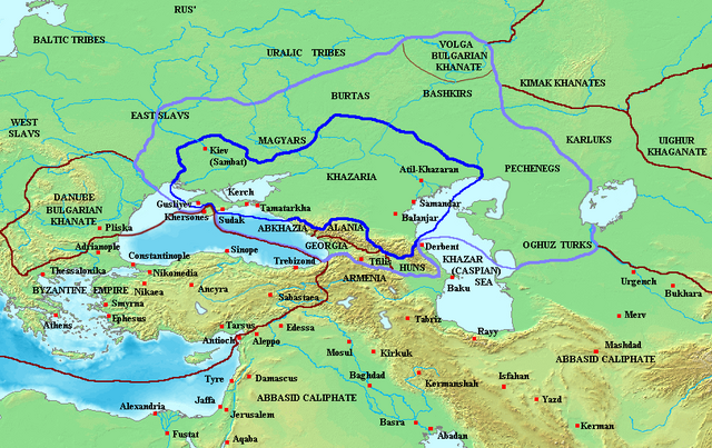
Map of the Khazar Khaganate and surrounding states, c. 820 CE. Area of direct Khazar control shown in dark blue, sphere of influence in purple. Other boundaries shown in dark red.
Made by User:Briangotts
许可协议
| 本文件采用知识共享署名-相同方式共享 3.0 未本地化版本许可协议授权。 受免責聲明的約束。 | ||
| ||
| 本许可协议标签作为GFDL许可协议更新的组成部分被添加至本文件。 |

|
已授权您依据自由软件基金会发行的无固定段落及封面封底文字(Invariant Sections, Front-Cover Texts, and Back-Cover Texts)的GNU自由文件许可协议1.2版或任意后续版本的条款,复制、传播和/或修改本文件。该协议的副本请见“GNU Free Documentation License”。 受免責聲明的約束。 |
文件历史
点击某个日期/时间查看对应时刻的文件。
| 日期/时间 | 缩略图 | 大小 | 用户 | 备注 | |
|---|---|---|---|---|---|
| 当前 | 2023年6月26日 (一) 07:29 | | 939 × 592(548 KB) | Johannnes89 | Reverted to version as of 18:29, 20 May 2016 (UTC) crosswiki image spam, often containing historical inaccuracies |
| 2023年6月25日 (日) 23:56 |  | 939 × 592(657 KB) | Valdazleifr | Fixed a minor toponymycal error | |
| 2016年5月20日 (五) 18:29 |  | 939 × 592(548 KB) | Julieta39 | Lakes, rivers, shorelines of the time, cosmetic. | |
| 2006年10月27日 (五) 15:20 |  | 939 × 592(336 KB) | Frode Inge Helland | == Summary == Map of the Khazar Khaganate and surrounding states, c. 820 CE. Area of direct Khazar control shown in dark blue, sphere of influence in purple. Other boundaries shown in dark red. Category:Historical maps by User:Briangotts == L | |
| 2006年10月27日 (五) 15:17 |  | 939 × 592(336 KB) | Frode Inge Helland | == Summary == Map of the Khazar Khaganate and surrounding states, c. 820 CE. Area of direct Khazar control shown in dark blue, sphere of influence in purple. Other boundaries shown in dark red. Category:Historical maps by User:Briangotts == L |
文件用途
以下2个页面使用本文件:
全域文件用途
以下其他wiki使用此文件:
- be-tarask.wikipedia.org上的用途
- da.wikipedia.org上的用途
- el.wikipedia.org上的用途
- en.wikipedia.org上的用途
- fr.wikipedia.org上的用途
- hu.wikipedia.org上的用途
- it.wikipedia.org上的用途
- ja.wikipedia.org上的用途
- mk.wikipedia.org上的用途
- no.wikipedia.org上的用途
- pnb.wikipedia.org上的用途
- sl.wikipedia.org上的用途
- tt.wikipedia.org上的用途
- uk.wikipedia.org上的用途