
File:Manama bahrain.jpg

本预览的尺寸:591 × 600像素。 其他分辨率:236 × 240像素 | 473 × 480像素 | 757 × 768像素 | 1,009 × 1,024像素 | 2,017 × 2,048像素 | 3,968 × 4,028像素。
原始文件 (3,968 × 4,028像素,文件大小:9.65 MB,MIME类型:image/jpeg)
摘要
| 描述 |
Español: Vista lateral de Bahréin desde el espacio
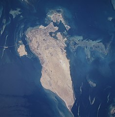
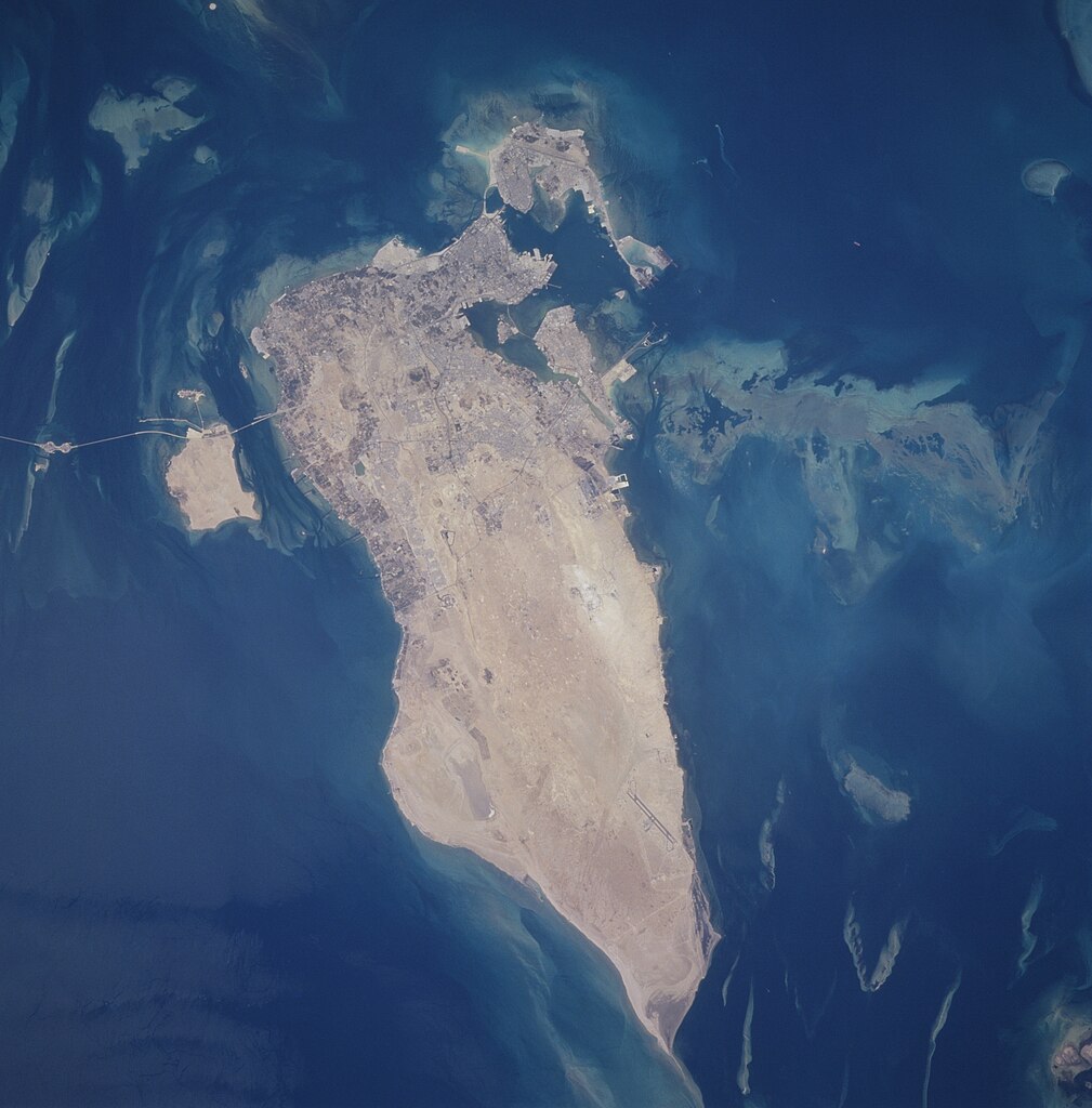
English: The capital city of Al Manamah, situated on the northeast tip of the island country of Bahrain, can be seen in this west-looking view. With a population of over 155000, Al Manamah is an international banking center with oil refineries, light industry, and is a duty free port. Tourism has also become a major industry. The main island of Bahrain is 30 miles (48 km) long north to south, and 10 miles (16 km) wide east to west. The island name comes from the Arabic word meaning "two seas". Bahrain is located 15 miles (24 km) off the eastern coast of Saudi Arabia in the Persian Gulf. The island is a low-lying barren desert with outcroppings of limestone that form low rolling hills, cliffs, and shallow ravines. The low rolling hills are called the Jabal Ad Dukhan (Mountains of Smoke) named for the mist that often wreathes the 543 foot-135 meters summit. Extending from the main island of Bahrain westward and exiting the view near the top center of the image is the causeway that connects Saudi Arabia to Bahrain. |
| 日期 | 摄于1996年6月25日, 10:31:09 |
| 来源 | https://eol.jsc.nasa.gov/SearchPhotos/photo.pl?mission=STS078&roll=748&frame=12 |
| 作者 | NASA/STS-78 |
| 物体位置 | | 在以下服务上查看本图像和附近其他图像: OpenStreetMap |
|---|
本图像或视频收录于美国国家航空航天局 (NASA)休斯顿太空中心(Johnson Space Center),其照片编号是: STS078-748-12 此标签不表示文件的著作权状态。任何文件在附有此标签的同時还需要一个有效的著作权标签。请参阅许可协议说明页面以了解更多信息。 其他语言:
|
摘要
This file is in the public domain in the United States because it was created by the Image Science & Analysis Laboratory, of the NASA Johnson Space Center. NASA copyright policy states that "NASA material is not protected by copyright unless noted". (NASA media use guidelines or Conditions of Use of Astronaut Photographs).
Photo source: STS078-748-12.
|
文件历史
点击某个日期/时间查看对应时刻的文件。
| 日期/时间 | 缩略图 | 大小 | 用户 | 备注 | |
|---|---|---|---|---|---|
| 当前 | 2020年9月27日 (日) 02:13 | | 3,968 × 4,028(9.65 MB) | Huntster | Full resolution from NASA. |
| 2010年2月21日 (日) 05:00 |  | 630 × 640(97 KB) | Rehman | Align to North | |
| 2005年5月31日 (二) 22:40 |  | 640 × 630(85 KB) | Taichi | Bahrein desde el espacio. NASA 1996 image description [http://eol.jsc.nasa.gov/sseop/EFS/photoinfo.pl?PHOTO=STS078-748-12 here] {{PD-USGov-NASA}} |
文件用途
以下页面使用本文件:
全域文件用途
以下其他wiki使用此文件:
- af.wikipedia.org上的用途
- en.wikipedia.org上的用途
- eo.wikipedia.org上的用途
- gl.wikipedia.org上的用途
- he.wikipedia.org上的用途
- hif.wikipedia.org上的用途
- hr.wikipedia.org上的用途
- id.wikipedia.org上的用途
- lt.wikipedia.org上的用途
- ms.wikipedia.org上的用途
- pl.wikipedia.org上的用途
- ro.wikipedia.org上的用途
- sh.wikipedia.org上的用途
- simple.wikipedia.org上的用途
- tk.wikipedia.org上的用途
- uk.wikipedia.org上的用途