
File:Map-of-Ottoman-Empire-in-1900-German.svg

此SVG文件的PNG预览的大小:800 × 502像素。 其他分辨率:320 × 201像素 | 640 × 401像素 | 1,024 × 642像素 | 1,280 × 803像素 | 2,560 × 1,605像素 | 2,647 × 1,660像素。
原始文件 (SVG文件,尺寸为2,647 × 1,660像素,文件大小:82 KB)
| 描述 |
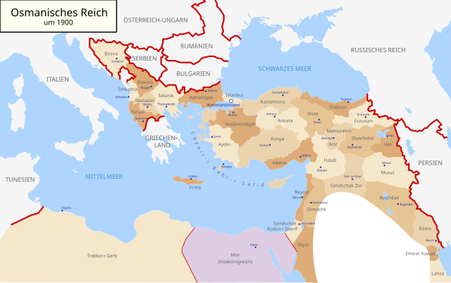
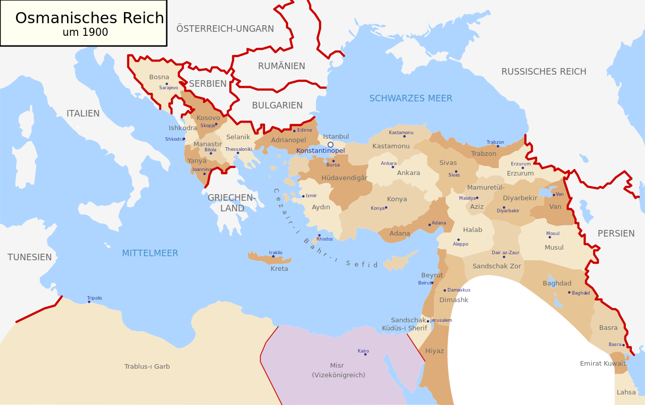
Deutsch: Karte des Osmanischen Reiches um 1900 in Deutsch
English: Map of Ottoman Empire (1900) in German |
| 日期 | (UTC) |
| 来源 | |
| 作者 |
|
| 其他版本 |
Map-of-Ottoman-Empire-in-1900-German.svg[]
此文件衍生的作品: |


.svg)
.jpg)
我,本作品著作权人,特此采用以下许可协议发表本作品:
| 我,本作品著作权人,释出本作品至公有领域。这适用于全世界。 在一些国家这可能不合法;如果是这样的话,那么: 我无条件地授予任何人以任何目的使用本作品的权利,除非这些条件是法律规定所必需的。 |
原始上传日志
This image is a derivative work of the following images:
- File:Map-of-Ottoman-Empire-in-1900-Latvian.svg licensed with PD-self
- 2008-01-30T21:53:09Z Juristiltins 885x557 (105823 Bytes) {{Information |Description=Map of Ottoman Empire (1900) in Latvian |Source=own work |Date=30 January 2008 |Author=Juris Tiltins |Permission=Free use and distribution permitted. |other_versions= }} [[Category:Maps of the Ottom
Uploaded with derivativeFX
文件历史
点击某个日期/时间查看对应时刻的文件。
| 日期/时间 | 缩略图 | 大小 | 用户 | 备注 | |
|---|---|---|---|---|---|
| 当前 | 2018年5月18日 (五) 09:25 | | 2,647 × 1,660(82 KB) | NordNordWest | corr |
| 2010年9月15日 (三) 16:03 |  | 2,647 × 1,660(79 KB) | NordNordWest | c | |
| 2010年9月15日 (三) 16:01 |  | 2,646 × 1,660(79 KB) | NordNordWest | c | |
| 2010年9月15日 (三) 16:00 |  | 2,646 × 1,660(79 KB) | NordNordWest | c | |
| 2010年8月28日 (六) 18:30 |  | 2,645 × 1,661(112 KB) | NordNordWest | bigger | |
| 2010年8月28日 (六) 18:18 |  | 885 × 557(96 KB) | NordNordWest | {{Information |Description={{de|Karte des Osmanischen Reiches um 1900 in Deutsch}} {{en|Map of Ottoman Empire (1900) in German}} |Source=*File:Map-of-Ottoman-Empire-in-1900-Latvian.svg |Date=2010-08-28 18:18 (UTC) |Author=*[[:File:Map-of-Ottoman-Emp |
文件用途
没有页面链接到本图像。
全域文件用途
以下其他wiki使用此文件:
- af.wikipedia.org上的用途
- als.wikipedia.org上的用途
- cy.wikipedia.org上的用途
- de.wikipedia.org上的用途
- en.wikipedia.org上的用途
- he.wikipedia.org上的用途
- it.wikipedia.org上的用途
- lv.wikipedia.org上的用途
- no.wikipedia.org上的用途
- pl.wikipedia.org上的用途
- pnb.wikipedia.org上的用途
- ru.wikipedia.org上的用途
- sk.wikipedia.org上的用途
- sr.wikipedia.org上的用途
- sv.wikipedia.org上的用途
- tr.wikipedia.org上的用途
- ur.wikipedia.org上的用途