
File:Map indicating Amundsen Gulf, Northwest Territories, Canada.png
此为最大尺寸。
Map_indicating_Amundsen_Gulf,_Northwest_Territories,_Canada.png (395 × 370像素,文件大小:60 KB,MIME类型:image/png)
摘要
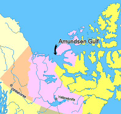
Map indicating Amundsen Gulf, Northwest Territories, Canada.
Nunavut
Northwest Territories
Yukon Territory
British Columbia
Alaska
© Her Majesty the Queen in Right of Canada, Department of Natural Resources. All rights reserved.
Licence Agreement
许可协议

|
本作品的著作权持有者允许任何人以任何目的使用该作品,包括无限制的再分发、商业性使用和修改内容。
使用注意:
|
文件历史
点击某个日期/时间查看对应时刻的文件。
| 日期/时间 | 缩略图 | 大小 | 用户 | 备注 | |
|---|---|---|---|---|---|
| 当前 | 2006年3月21日 (二) 01:42 | | 395 × 370(60 KB) | David Kernow~commonswiki | Map indicating Amundsen Gulf, Northwest Territories, Canada. {{legend|#ffff66|Nunavut}} {{legend|#ffccff|Northwest Territories}} {{legend|#ffcc99|Yukon Territory}} {{legend|#ffff99|British Columbia}} {{legend|#ffffcc|Alaska}} <br> © |
文件用途
以下页面使用本文件:
全域文件用途
以下其他wiki使用此文件:
- af.wikipedia.org上的用途
- az.wikipedia.org上的用途
- bg.wikipedia.org上的用途
- bn.wikipedia.org上的用途
- bs.wikipedia.org上的用途
- cs.wikipedia.org上的用途
- de.wikipedia.org上的用途
- en.wikipedia.org上的用途
- eo.wikipedia.org上的用途
- es.wikipedia.org上的用途
- et.wikipedia.org上的用途
- eu.wikipedia.org上的用途
- fa.wikipedia.org上的用途
- fr.wikipedia.org上的用途
- fy.wikipedia.org上的用途
- hi.wikipedia.org上的用途
- ilo.wikipedia.org上的用途
- it.wikipedia.org上的用途
- ja.wikipedia.org上的用途
- ka.wikipedia.org上的用途
- ko.wikipedia.org上的用途
- ku.wikipedia.org上的用途
- la.wikipedia.org上的用途
- lt.wikipedia.org上的用途
- mk.wikipedia.org上的用途
- nl.wikipedia.org上的用途
- nn.wikipedia.org上的用途
- pa.wikipedia.org上的用途
- pl.wikipedia.org上的用途
- pl.wiktionary.org上的用途
- pnb.wikipedia.org上的用途
- sh.wikipedia.org上的用途
- sl.wikipedia.org上的用途
- sr.wikipedia.org上的用途
- tr.wikipedia.org上的用途
- uk.wikipedia.org上的用途
- ur.wikipedia.org上的用途
- vi.wikipedia.org上的用途
- war.wikipedia.org上的用途
- xmf.wikipedia.org上的用途
- zh-min-nan.wikipedia.org上的用途