
File:Mugello Racing Circuit track map.svg

此SVG文件的PNG预览的大小:800 × 501像素。 其他分辨率:320 × 200像素 | 640 × 401像素 | 1,024 × 641像素 | 1,280 × 801像素 | 2,560 × 1,603像素 | 1,391 × 871像素。
原始文件 (SVG文件,尺寸为1,391 × 871像素,文件大小:64 KB)
摘要
| 描述 |
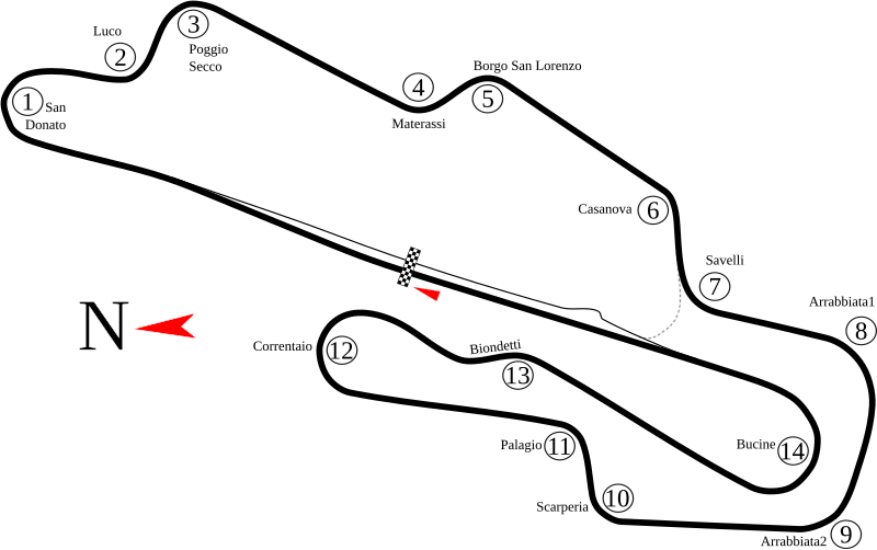
English: Track map of Mugello Circuit in Italy. The gray dashed line represents pavement that has the same width as the main track, but only leads to pit road. Because of its location, the author of this image believes that it is only used by cars needing a shorter route back to the paddock. |
| 日期 | 8-5-2008 |
| 来源 | 自己的作品 |
| 作者 | Will Pittenger |
| 其他版本 |
|
.png)
| 相机位置 | | 在以下服务上查看本图像和附近其他图像: OpenStreetMap |
|---|
许可协议
我,本作品著作权人,特此采用以下许可协议发表本作品:
本文件采用知识共享署名-相同方式共享 3.0 未本地化版本许可协议授权。
- 您可以自由地:
- 共享 – 复制、发行并传播本作品
- 修改 – 改编作品
- 惟须遵守下列条件:
- 署名 – 您必须对作品进行署名,提供授权条款的链接,并说明是否对原始内容进行了更改。您可以用任何合理的方式来署名,但不得以任何方式表明许可人认可您或您的使用。
- 相同方式共享 – 如果您再混合、转换或者基于本作品进行创作,您必须以与原先许可协议相同或相兼容的许可协议分发您贡献的作品。
文件历史
点击某个日期/时间查看对应时刻的文件。
| 日期/时间 | 缩略图 | 大小 | 用户 | 备注 | |
|---|---|---|---|---|---|
| 当前 | 2010年7月4日 (日) 22:23 | | 1,391 × 871(64 KB) | Restu20 | correct some name |
| 2008年8月5日 (二) 09:16 |  | 1,391 × 871(64 KB) | Will Pittenger | New version fixes the vertical black bar that shouldn't have been there. (It was actually an unneeded flowed text box that got in somehow.) | |
| 2008年8月5日 (二) 08:54 |  | 1,391 × 871(64 KB) | Will Pittenger | New version has the turn numbers grouped to matching turn names | |
| 2008年8月5日 (二) 08:45 |  | 1,391 × 871(63 KB) | Will Pittenger | New version has larger North Arrow and Start/Finish line | |
| 2008年8月5日 (二) 08:32 |  | 1,391 × 871(62 KB) | Will Pittenger | {{Information |Description={{en|1=Track map of w:Mugello Circuit in Italy. The gray dashed line represents pavement that has the same width as the main track, but only leads to pit road. Because of its location, the author of this image believes th |
文件用途
以下4个页面使用本文件:
全域文件用途
以下其他wiki使用此文件:
- ar.wikipedia.org上的用途
- جائزة إيطاليا الكبرى للدراجات النارية 2006
- حلبة موجيلو
- جائزة إيطاليا الكبرى للدراجات النارية 2004
- جائزة إيطاليا الكبرى للدراجات النارية 2005
- جائزة إيطاليا الكبرى للدراجات النارية 2007
- جائزة إيطاليا الكبرى للدراجات النارية 2008
- جائزة إيطاليا الكبرى للدراجات النارية 2009
- جائزة إيطاليا الكبرى للدراجات النارية 2010
- جائزة إيطاليا الكبرى للدراجات النارية 2011
- جائزة إيطاليا الكبرى للدراجات النارية 2012
- جائزة إيطاليا الكبرى للدراجات النارية 2013
- جائزة إيطاليا الكبرى للدراجات النارية 2014
- جائزة إيطاليا الكبرى للدراجات النارية 2015
- جائزة إيطاليا الكبرى للدراجات النارية 1992
- جائزة إيطاليا الكبرى للدراجات النارية 1994
- جائزة إيطاليا الكبرى للدراجات النارية 1995
- جائزة إيطاليا الكبرى للدراجات النارية 1996
- جائزة إيطاليا الكبرى للدراجات النارية 1997
- جائزة إيطاليا الكبرى للدراجات النارية 1998
- جائزة إيطاليا الكبرى للدراجات النارية 1999
- جائزة إيطاليا الكبرى للدراجات النارية 2000
- جائزة سان مارينو الكبرى للدراجات النارية 1991
- جائزة سان مارينو الكبرى للدراجات النارية 1993
- جائزة الأمم الكبرى للدراجات النارية 1978
- جائزة الأمم الكبرى للدراجات النارية 1976
- جائزة إيطاليا الكبرى للدراجات النارية 2018
- جائزة إيطاليا الكبرى للدراجات النارية 2019
- ast.wikipedia.org上的用途
- ca.wikipedia.org上的用途
- cs.wikipedia.org上的用途
- de.wikipedia.org上的用途
- en.wikipedia.org上的用途
- es.wikipedia.org上的用途
- Anexo:Grandes Premios de Fórmula 1
- Anexo:Circuitos de Fórmula 1
- Autódromo Internacional del Mugello
- Gran Premio de Italia de Motociclismo
- Temporada 2012 de Fórmula 1
- Anexo:Pretemporada 2012 de Fórmula 1
- Temporada 2014 de MotoGP
- Gran Premio de Italia de Motociclismo de 2012
- Gran Premio de Italia de Motociclismo de 2013
- Gran Premio de Italia de Motociclismo de 2014
- Gran Premio de Italia de Motociclismo de 2015
查看本文件的更多全域用途。