
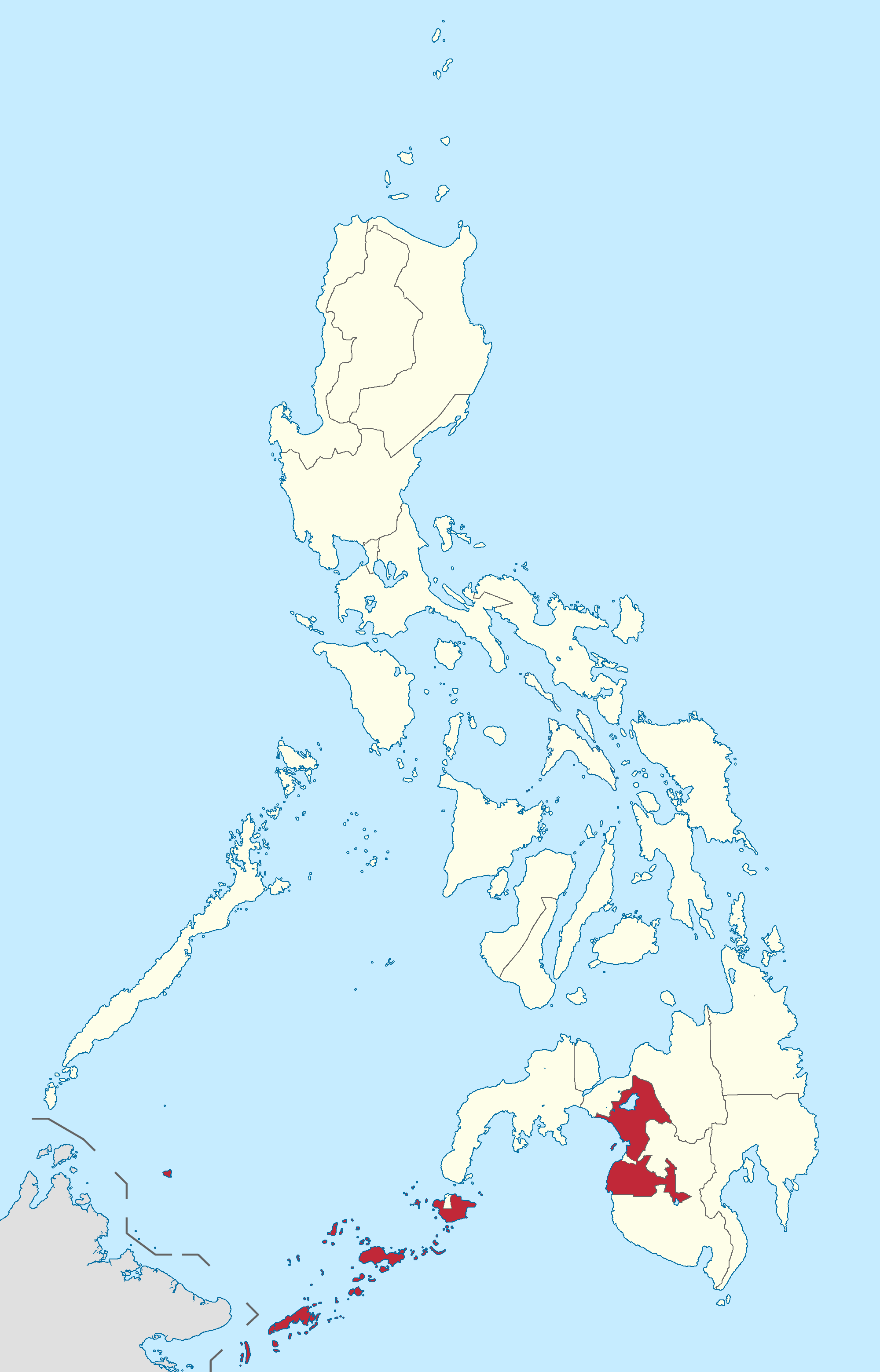
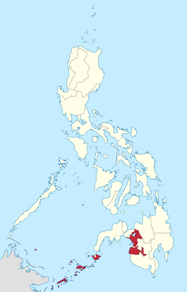
File:Ph fil armm.png
本预览的尺寸:384 × 599像素。 其他分辨率:154 × 240像素 | 308 × 480像素 | 492 × 768像素 | 656 × 1,024像素 | 2,000 × 3,120像素。
原始文件 (2,000 × 3,120像素,文件大小:137 KB,MIME类型:image/png)
摘要
| 描述 |
English: Autonomous Region in Muslim Mindanao location in the Philippines
Filipino: Kinaroroonan ng Rehiyong Awtonomus sa Muslim Mindanao sa Pilipinas |
| 日期 | |
| 来源 |
BlankMap-Philippines.png by User:TheCoffee
|
| 作者 | Roel Balingit |
许可协议
我,本作品著作权人,特此采用以下许可协议发表本作品:
本文件采用知识共享署名-相同方式共享 3.0 未本地化版本许可协议授权。
- 您可以自由地:
- 共享 – 复制、发行并传播本作品
- 修改 – 改编作品
- 惟须遵守下列条件:
- 署名 – 您必须对作品进行署名,提供授权条款的链接,并说明是否对原始内容进行了更改。您可以用任何合理的方式来署名,但不得以任何方式表明许可人认可您或您的使用。
- 相同方式共享 – 如果您再混合、转换或者基于本作品进行创作,您必须以与原先许可协议相同或相兼容的许可协议分发您贡献的作品。

|
If you choose to use this work under the Creative Commons license stated above, the author, Roel Balingit (Namayan), would like you to attribute the work to him (among other requirements such as indicating that the work is licensed under the Creative Commons) with the following text or similar:
© Roel Balingit, 2012.
His name should be a link to the Wikimedia Commons userpage Namayan. If a link is not possible, then the url should be placed in parentheses after the name. If the work has been substantially altered by other people (see the File history section below), then this particular attribution requirement is waived, which means you can attribute the work in any reasonable manner. This attribution requirement is provided pursuant to the Creative Commons Attribution mechanism where "you must attribute the work in the manner specified by the author or licensor (but not in any way that suggests that they endorse you or your use of the work)." (See "Attribution" in the Creative Commons website.)
|
文件历史
点击某个日期/时间查看对应时刻的文件。
| 日期/时间 | 缩略图 | 大小 | 用户 | 备注 | |
|---|---|---|---|---|---|
| 当前 | 2019年1月27日 (日) 10:50 | | 2,000 × 3,120(137 KB) | Hariboneagle927 | Reverted to version as of 04:21, 6 August 2012 (UTC) |
| 2015年6月5日 (五) 10:16 |  | 2,000 × 3,120(136 KB) | Namayan | Removed Region 6/7 boundaries, Negros Island Region created | |
| 2012年8月6日 (一) 04:21 |  | 2,000 × 3,120(137 KB) | Namayan | Removed Camarines Norte and Camarines Sur boundaries | |
| 2012年8月6日 (一) 03:58 |  | 2,000 × 3,120(137 KB) | Namayan | Removed error in Region 1 border | |
| 2012年8月6日 (一) 03:56 |  | 2,000 × 3,120(137 KB) | Namayan | Demarcated Dinagat Islands boundary | |
| 2012年8月5日 (日) 09:27 |  | 2,000 × 3,120(137 KB) | Namayan | Fixed border with Malaysia | |
| 2012年8月4日 (六) 18:55 |  | 2,000 × 3,120(140 KB) | Namayan | Added border with Malaysia | |
| 2012年8月4日 (六) 17:02 |  | 2,000 × 3,120(127 KB) | Namayan | Color changed, label removed | |
| 2012年8月4日 (六) 06:02 |  | 2,000 × 3,120(154 KB) | Namayan |
文件用途
以下页面使用本文件:
全域文件用途
以下其他wiki使用此文件:
- az.wikipedia.org上的用途
- en.wikipedia.org上的用途
- Ganassi, Lanao del Sur
- Hadji Panglima Tahil
- Indanan
- Kalingalan Caluang
- Lugus, Sulu
- Luuk, Sulu
- Maimbung
- Panamao
- Pandami
- Panglima Estino
- Pangutaran
- Parang, Sulu
- Pata, Sulu
- Patikul
- Siasi
- Tapul
- Banguingui, Sulu
- Languyan
- Panglima Sugala
- Sapa-Sapa
- South Ubian
- Bacolod-Kalawi
- Balabagan
- Binidayan
- Buadiposo-Buntong
- Bubong
- Calanogas
- Ditsaan-Ramain
- Kapai
- Kapatagan, Lanao del Sur
- Lumba-Bayabao
- Lumbayanague
- Madalum
- Madamba
- Maguing
- Marantao
- Pagayawan
- Poona Bayabao
- Sultan Dumalondong
- Picong, Lanao del Sur
- Taraka, Lanao del Sur
- Wao, Lanao del Sur
- Tubaran
- Barira
- Lantawan
- Maluso
- Sumisip
- Tipo-Tipo
- Tuburan, Basilan
查看本文件的更多全域用途。