File:Typhoon Khanun 2005.jpg

页面内容不支持其他语言。
這個文件來自維基共享資源
维基百科,自由的百科全书

原始文件(6,000 × 6,000像素,文件大小:4.48 MB,MIME类型:image/jpeg


摘要

描述

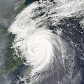
Typhoon Khanun was poised to make landfall on the coast of mainland China when the Moderate Resolution Imaging Spectroradiometer (MODIS) on NASA’s Terra satellite captured this image at 11:20 a.m. local time, on September 11, 2005. At the time of this MODIS observation, Khanun had sustained winds of 210 kilometers per hour (130 miles per hour).

As Khanun moved in towards China, outflowing wind patterns from the storm pushed away polluted air ahead of it. In the MODIS image, this wind pattern shows up as clear views immediately outside the cloud bands, while smog piles up just beyond the storm’s influence. Khanun is the 15th typhoon to hit China in 2005. The storm is believed to be responsible for 14 reported deaths, mostly from mudslides caused by the heavy rains brought in with the storm system. The land is already saturated from other recent typhoons, so the risk of mudslide events has been unusually high. Nearly one million people were evacuated from coastal areas in the typhoon’s path, including some residents of Shanghai.
日期
来源 http://earthobservatory.nasa.gov/NaturalHazards/natural_hazards_v2.php3?img_id=13128
作者 NASA image created by Jesse Allen, Earth Observatory, using data courtesy of the MODIS Rapid Response team.
授权
(二次使用本文件)
Public domain 本文件完全由NASA创作,在美国属于公有领域。根据NASA的版权方针,NASA的材料除非另有声明否则不受版权保护。(参见Template:PD-USGov/zhNASA版权方针页面JPL图片使用方针。)
警告:

说明

添加一行文字以描述该文件所表现的内容

此文件中描述的项目

描繪內容

文件历史

点击某个日期/时间查看对应时刻的文件。

日期/时间缩⁠略⁠图大小用户备注
当前2006年9月6日 (三) 22:562006年9月6日 (三) 22:56版本的缩略图6,000 × 6,000(4.48 MB)Good kitty== Summary == {{Information |Description=Typhoon Khanun was poised to make landfall on the coast of mainland China when the Moderate Resolution Imaging Spectroradiometer (MODIS) on NASA’s Terra satellite captured this image at 11:20 a.m. local time, on

全域文件用途

以下其他wiki使用此文件:

元数据