
File:Typhoon Sonca 2005.jpg

本预览的尺寸:600 × 600像素。 其他分辨率:240 × 240像素 | 480 × 480像素 | 768 × 768像素 | 1,024 × 1,024像素 | 2,048 × 2,048像素 | 5,400 × 5,400像素。
原始文件 (5,400 × 5,400像素,文件大小:3.32 MB,MIME类型:image/jpeg)
摘要
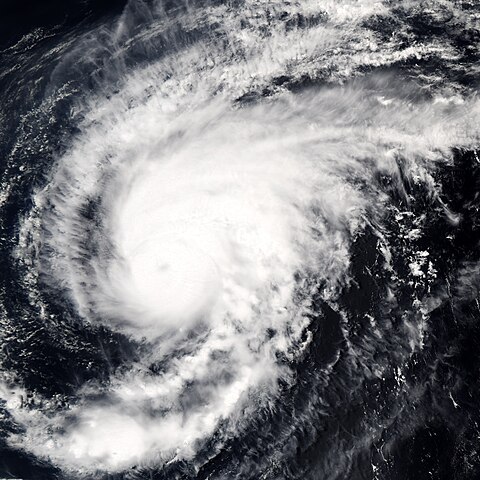
| 描述 | Typhoon Sonca was just beginning to weaken on April 25, 2005, when the Moderate Resolution Imaging Spectroradiometer (MODIS) on NASA’s Aqua satellite captured this image of the storm. Sonca is spinning across the Philippine Sea, heading towards Iwo Jima island south of Japan’s main island, Honshu. At the time this image was taken at 04:10 UTC, the storm’s winds were slowing from 213 kilometers per hour (132 mph) with gusts to 259 kph (161 mph) to 204 kph (127 mph) with gusts to 250 kph (155 mph). An eye is barely visible as a circular smudge in the center of the storm. The storm is predicted to continue to weaken. | |||||
| 日期 | ||||||
| 来源 | http://earthobservatory.nasa.gov/NaturalHazards/natural_hazards_v2.php3?img_id=12838 | |||||
| 作者 | NASA image created by Jesse Allen, Earth Observatory, using data obtained from the MODIS Rapid Response team. | |||||
| 授权 (二次使用本文件) |
|

文件历史
点击某个日期/时间查看对应时刻的文件。
| 日期/时间 | 缩略图 | 大小 | 用户 | 备注 | |
|---|---|---|---|---|---|
| 当前 | 2006年9月6日 (三) 15:27 | | 5,400 × 5,400(3.32 MB) | Good kitty | == Summary == {{Information |Description=Typhoon Sonca was just beginning to weaken on April 25, 2005, when the Moderate Resolution Imaging Spectroradiometer (MODIS) on NASA’s Aqua satellite captured this image of the storm. Sonca is spinning across the |
文件用途
以下页面使用本文件:
全域文件用途
以下其他wiki使用此文件:
- en.wikipedia.org上的用途
- ja.wikipedia.org上的用途