
File:Yugoslavia location map.svg

此SVG文件的PNG预览的大小:450 × 521像素。 其他分辨率:207 × 240像素 | 415 × 480像素 | 663 × 768像素 | 884 × 1,024像素 | 1,769 × 2,048像素。
原始文件 (SVG文件,尺寸为450 × 521像素,文件大小:762 KB)
摘要
| 描述 |
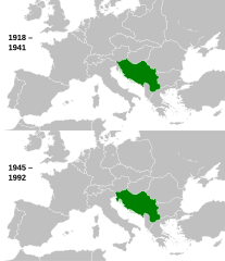
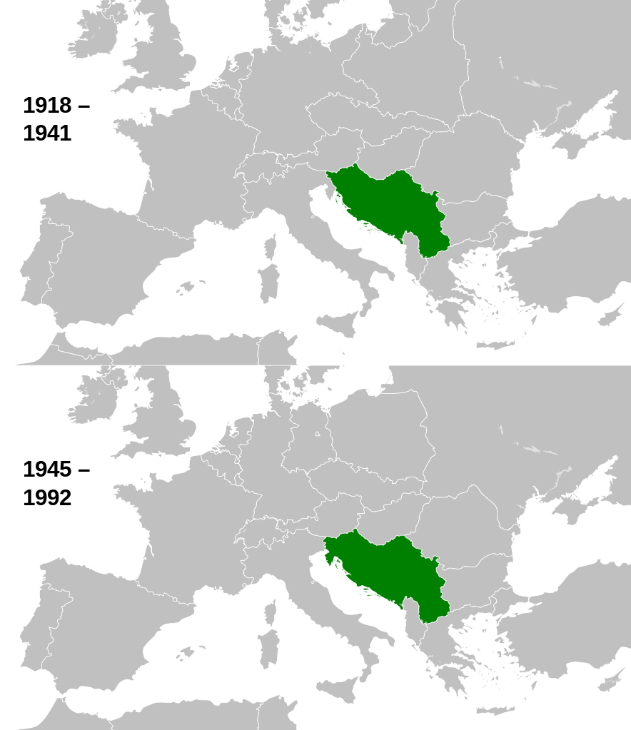
English: This is a map of the evolution of Yugoslavia from 1918 to 1992. |
| 日期 | |
| 来源 |
本檔案衍生自: |
| 作者 |
|

.svg)
许可协议
我,本作品著作权人,特此采用以下许可协议发表本作品:
本文件采用知识共享署名-相同方式共享 3.0 未本地化版本许可协议授权。
- 您可以自由地:
- 共享 – 复制、发行并传播本作品
- 修改 – 改编作品
- 惟须遵守下列条件:
- 署名 – 您必须对作品进行署名,提供授权条款的链接,并说明是否对原始内容进行了更改。您可以用任何合理的方式来署名,但不得以任何方式表明许可人认可您或您的使用。
- 相同方式共享 – 如果您再混合、转换或者基于本作品进行创作,您必须以与原先许可协议相同或相兼容的许可协议分发您贡献的作品。
原始上传日志
This image is a derivative work of the following images:
- File:History_of_Yugoslavia.svg licensed with Cc-by-sa-3.0
Uploaded with derivativeFX
文件历史
点击某个日期/时间查看对应时刻的文件。
| 日期/时间 | 缩略图 | 大小 | 用户 | 备注 | |
|---|---|---|---|---|---|
| 当前 | 2013年8月12日 (一) 10:01 | | 450 × 521(762 KB) | Alphathon | Fixed Hungarian pre-1941 border |
| 2013年4月10日 (三) 14:07 |  | 450 × 521(758 KB) | Alphathon | == {{int:filedesc}} == {{Information |Description={{en|1=This is a map of the evolution of Yugoslavia from 1918 to 1992.}} |date=2013-03-25 15:13:51 |Source={{Derived from|History_of_Yugoslavia.svg|Blank_map_of_Europe_1929-1938.svg|Blank_map_of_Europe_... |
文件用途
以下页面使用本文件:
全域文件用途
以下其他wiki使用此文件:
- am.wikipedia.org上的用途
- ang.wikipedia.org上的用途
- ar.wikipedia.org上的用途
- arz.wikipedia.org上的用途
- ast.wikipedia.org上的用途
- ba.wikipedia.org上的用途
- bn.wikipedia.org上的用途
- ca.wikipedia.org上的用途
- csb.wikipedia.org上的用途
- el.wikipedia.org上的用途
- en.wikipedia.org上的用途
- es.wikipedia.org上的用途
- et.wikipedia.org上的用途
- eu.wikipedia.org上的用途
- fa.wikipedia.org上的用途
- fi.wikipedia.org上的用途
- ga.wikipedia.org上的用途
- gd.wikipedia.org上的用途
- gl.wikipedia.org上的用途
- hy.wikipedia.org上的用途
- ia.wikipedia.org上的用途
- id.wikipedia.org上的用途
- ie.wikipedia.org上的用途
- kk.wikipedia.org上的用途
- km.wikipedia.org上的用途
- ko.wikipedia.org上的用途
- ku.wikipedia.org上的用途
- li.wikipedia.org上的用途
- lt.wikipedia.org上的用途
- ms.wikipedia.org上的用途
- mwl.wikipedia.org上的用途
- my.wikipedia.org上的用途
- mzn.wikipedia.org上的用途
- nds-nl.wikipedia.org上的用途
- ne.wikipedia.org上的用途
- no.wikipedia.org上的用途
- pl.wikipedia.org上的用途
- pl.wiktionary.org上的用途
- ps.wikipedia.org上的用途
- pt.wikipedia.org上的用途
- simple.wikipedia.org上的用途
- si.wikipedia.org上的用途
- sk.wikipedia.org上的用途
查看本文件的更多全域用途。