
File:2014 West Africa Ebola virus outbreak situation map.jpg
預覽大小:706 × 599 像素。 其他解析度:283 × 240 像素 | 566 × 480 像素 | 905 × 768 像素 | 1,039 × 882 像素。
原始檔案 (1,039 × 882 像素,檔案大小:160 KB,MIME 類型:image/jpeg)


摘要
| 描述 |
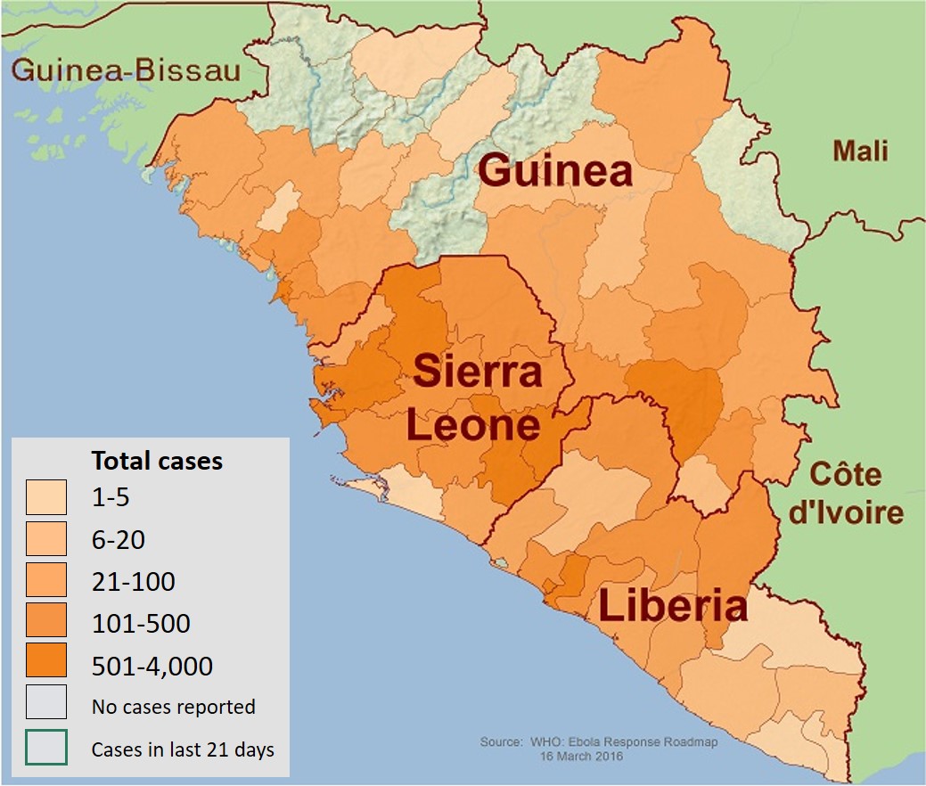
English: This is a map of the distribution of the Ebola virus epidemic in Guinea, Liberia, and Sierra Leone as of 17 December 2014. |
| 日期 | |
| 來源 | https://www.cdc.gov/vhf/ebola/resources/distribution-map-guinea-outbreak.html |
| 作者 | Centers for Disease Control and Prevention (CDC) |
| 其他版本 |
 |
授權條款
|
|
檔案歷史
點選日期/時間以檢視該時間的檔案版本。
| 日期/時間 | 縮圖 | 尺寸 | 使用者 | 備註 | |
|---|---|---|---|---|---|
| 目前 | 2019年5月12日 (日) 05:21 | | 1,039 × 882(160 KB) | Evolution and evolvability | Updated figure legend at readable size |
| 2016年3月19日 (六) 23:08 |  | 665 × 564(111 KB) | RobiH | Updated from source. | |
| 2016年3月1日 (二) 20:47 |  | 665 × 564(112 KB) | RobiH | Updated from Source | |
| 2016年2月15日 (一) 21:58 |  | 665 × 564(112 KB) | RobiH | Updated from source | |
| 2016年2月1日 (一) 20:12 |  | 665 × 564(237 KB) | RobiH | Updated from Source | |
| 2016年1月16日 (六) 21:32 |  | 665 × 564(122 KB) | RobiH | Updated from source. | |
| 2015年12月29日 (二) 21:09 |  | 665 × 564(123 KB) | RobiH | Updated from source. | |
| 2015年12月14日 (一) 23:26 |  | 665 × 564(112 KB) | RobiH | Updated from source | |
| 2015年12月1日 (二) 19:41 |  | 665 × 564(112 KB) | RobiH | Updated from source. | |
| 2015年12月1日 (二) 19:38 |  | 665 × 564(112 KB) | RobiH | Updated from source. |
檔案用途
下列頁面有用到此檔案:
全域檔案使用狀況
以下其他 wiki 使用了這個檔案:
- als.wikipedia.org 的使用狀況
- ca.wikipedia.org 的使用狀況
- de.wikipedia.org 的使用狀況
- en.wikipedia.org 的使用狀況
- en.wikibooks.org 的使用狀況
- en.wikiversity.org 的使用狀況
- es.wikipedia.org 的使用狀況
- fa.wikipedia.org 的使用狀況
- fi.wikipedia.org 的使用狀況
- fr.wikinews.org 的使用狀況
- hu.wikipedia.org 的使用狀況
- it.wikipedia.org 的使用狀況
- ja.wikipedia.org 的使用狀況
- ja.wikinews.org 的使用狀況
- ko.wikipedia.org 的使用狀況
- nl.wikipedia.org 的使用狀況
- no.wikipedia.org 的使用狀況
- ro.wikipedia.org 的使用狀況
- ru.wikipedia.org 的使用狀況
- ru.wikinews.org 的使用狀況
- sco.wikipedia.org 的使用狀況
- simple.wikipedia.org 的使用狀況
- vi.wikipedia.org 的使用狀況
- www.wikidata.org 的使用狀況