
File:Indigenous American Nations, 16th century - 2022 edition.jpg

預覽大小:800 × 500 像素。 其他解析度:320 × 200 像素 | 640 × 400 像素 | 1,024 × 640 像素 | 1,280 × 800 像素 | 2,560 × 1,600 像素 | 17,280 × 10,800 像素。
原始檔案 (17,280 × 10,800 像素,檔案大小:24.71 MB,MIME 類型:image/jpeg)
摘要
| 警告 | 部分瀏覽器在瀏覽此圖片的完整大小時可能會遇到困難:該圖片中有數量巨大的像素點,可能無法完全載入或者導致您的瀏覽器停止回應。 |
|---|
| 描述 |
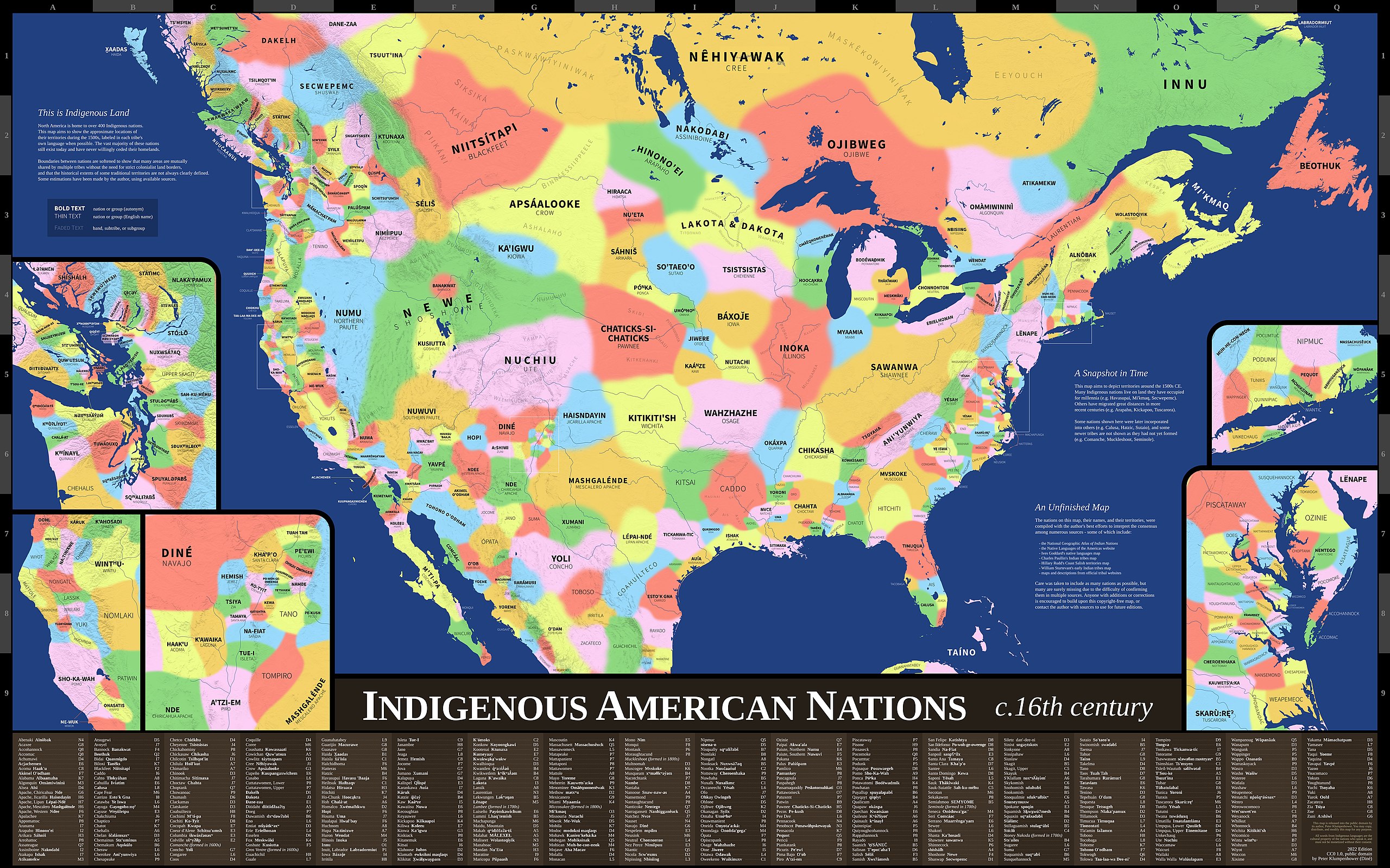
English: Map showing the approximate locations of the indigenous nations in what is now the United States during the 1500s. Nations are labeled in each tribe's own language when possible. Map uses Mercator projection. |
| 日期 | |
| 來源 | Indigenous America Maps |
| 作者 | Peter Klumpenhower |
| 授權許可 (重用此檔案) |
"This map is released into the public domain by its author, Peter Klumpenhower. You may copy, distribute, and modify this map for any purpose… CC0 1.0, public domain" (See lower right corner of map.) |
授權條款
| 此檔案在創用CC CC0 1.0 通用公有領域貢獻宣告之下分發。 | |
| 在此宣告之下分發本作品者,已依據各國著作權法,在全世界放棄其對本作品所擁有的著作權及所有相關相似的法律權利,從而將本作品貢獻至公有領域。您可以複製、修改、分發和演示該作品,用於任何商業用途,所有這些都不需要請求授權。
|
檔案歷史
點選日期/時間以檢視該時間的檔案版本。
| 日期/時間 | 縮圖 | 尺寸 | 使用者 | 備註 | |
|---|---|---|---|---|---|
| 目前 | 2022年3月20日 (日) 20:07 | | 17,280 × 10,800(24.71 MB) | Nosferattus | Uploaded a work by Peter Klumpenhower from [https://indigamerica.blogspot.com/p/downloads.html Indigenous America Maps] with UploadWizard |
檔案用途
下列頁面有用到此檔案:
全域檔案使用狀況
以下其他 wiki 使用了這個檔案:
- be.wikipedia.org 的使用狀況
- en.wikipedia.org 的使用狀況
- en.wikiquote.org 的使用狀況