
File:Vicente 2005-09-16 0550Z.jpg

預覽大小:480 × 600 像素。 其他解析度:192 × 240 像素 | 384 × 480 像素 | 614 × 768 像素 | 819 × 1,024 像素 | 1,638 × 2,048 像素 | 6,400 × 8,000 像素。
原始檔案 (6,400 × 8,000 像素,檔案大小:6.8 MB,MIME 類型:image/jpeg)
摘要
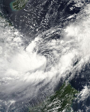
| 描述 | This image of Tropical Storm Vicente was captured by the MODIS instrument on NASA's Aqua satellite at 0546 UTC when it was located in the South China Sea. The maximum sustained winds for the storm were 30 knots (10-minute average) and the minimum pressure was about 1000 mb. | ||||||
| 日期 | |||||||
| 來源 | http://www.nrlmry.navy.mil/tc_pages/tc_home.html | ||||||
| 作者 | Naval Research Laboratory | ||||||
| 授權許可 (重用此檔案) |
|
||||||

檔案歷史
點選日期/時間以檢視該時間的檔案版本。
| 日期/時間 | 縮圖 | 尺寸 | 使用者 | 備註 | |
|---|---|---|---|---|---|
| 目前 | 2020年9月29日 (二) 15:55 | | 6,400 × 8,000(6.8 MB) | FleurDeOdile | dimensions |
| 2017年12月13日 (三) 04:26 |  | 6,706 × 6,562(3.98 MB) | TheAustinMan | Color and grid-less | |
| 2006年9月14日 (四) 16:56 |  | 3,875 × 3,875(1.63 MB) | Good kitty | == Summary == {{Information |Description=This image of Tropical Storm Vicente was captured by the MODIS instrument on NASA's Aqua satellite at 0546 UTC when it was located in the South China Sea. The maximum sustained winds for the storm were 30 knots (10 |
檔案用途
下列頁面有用到此檔案:
全域檔案使用狀況
以下其他 wiki 使用了這個檔案:
- en.wikipedia.org 的使用狀況
- es.wikipedia.org 的使用狀況
- ja.wikipedia.org 的使用狀況
- ko.wikipedia.org 的使用狀況
- pt.wikipedia.org 的使用狀況
- vi.wikipedia.org 的使用狀況