
File:World population density 1994.png
預覽大小:800 × 475 像素。 其他解析度:320 × 190 像素 | 640 × 380 像素 | 1,024 × 608 像素 | 1,280 × 761 像素 | 2,560 × 1,521 像素 | 6,693 × 3,977 像素。
原始檔案 (6,693 × 3,977 像素,檔案大小:955 KB,MIME 類型:image/png)
摘要
| 描述 |
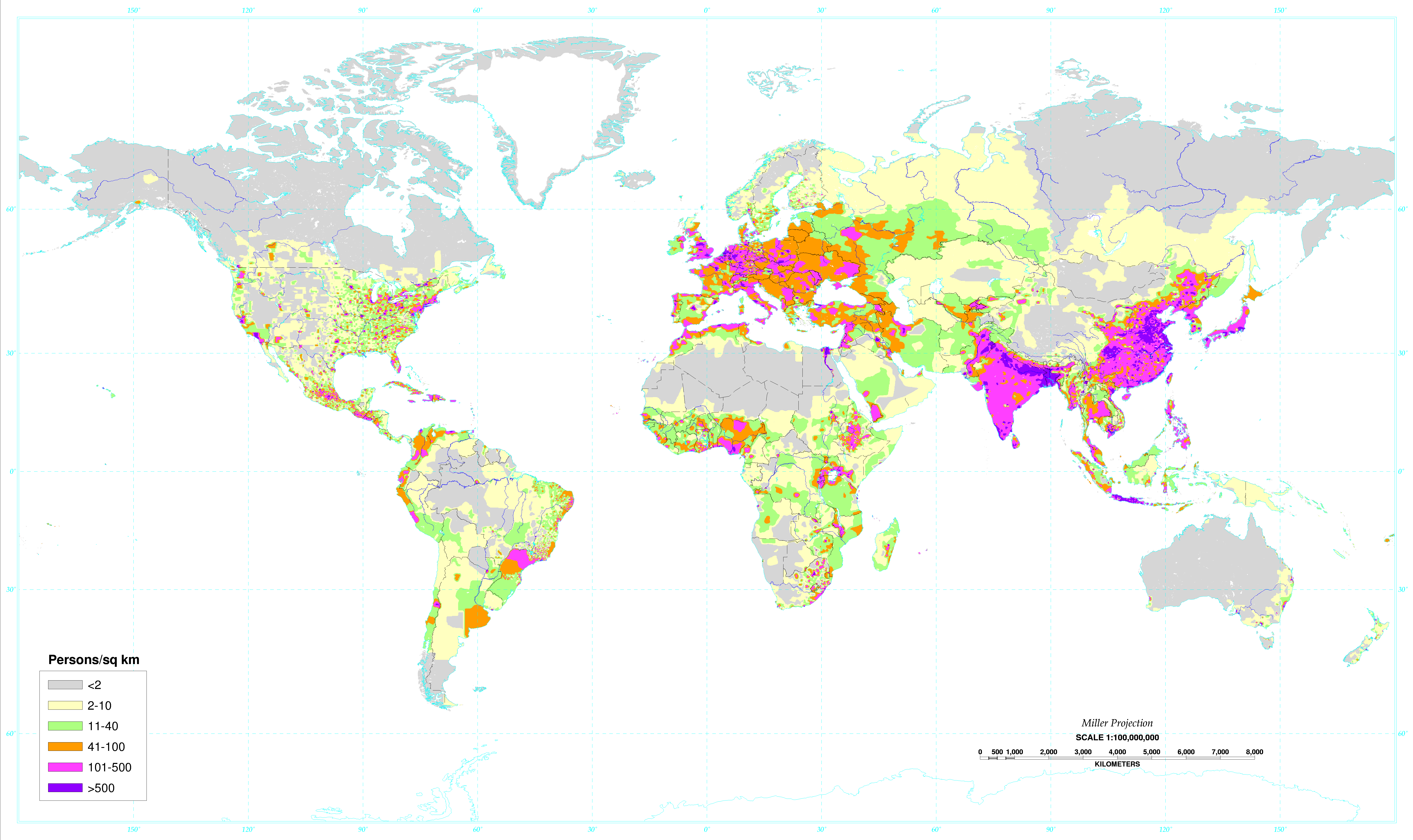
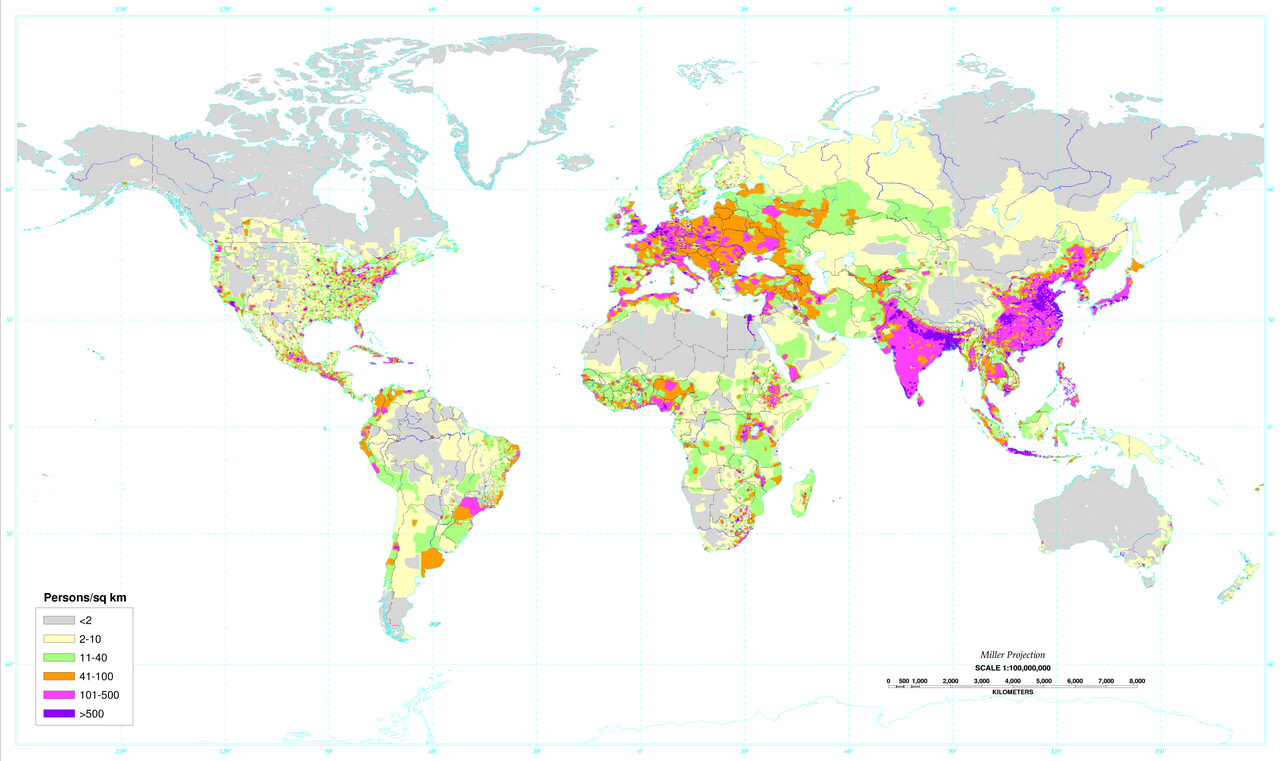
English: World map of the population density in 1994. A more recent population density map can be found at http://sedac.ciesin.columbia.edu/gpw/
Español: Mapa de la densidad de población mundial en 1994. Un mapa de densidad de población más reciente puede verse en http://sedac.ciesin.columbia.edu/gpw/. |
| 日期 | Data from 1994. Image made in 2000. |
| 來源 | Global Population Density Map. |
| 作者 | United States Department of Agriculture (USDA) |
| 其他版本 |
 World population density 1994 - with equator.png |

|
本圖片是以PNG、GIF或JPEG格式上傳。然而,其中包含的資料或訊息,應該重新建立成可縮放向量圖形(SVG)檔案,以更有效率或更準確的方式儲存。如有可能,請上傳本圖片的SVG格式版本。在上傳之後,請修改維基各姊妹計畫中所有使用舊版圖片的條目(列在圖像連結章節中),替換為新版圖片,並在舊圖片的描述頁中加入{{Vector version available|新圖片名稱.svg}}模板,同時移除本模板。
|
授權條款
此作品在美國屬於公有領域,因為其是由美國政府的官員或僱員,基於其個人公務目的製作的作品,參考美國法典第17篇第1章第105條。
注意︰本模板僅適用於美國聯邦政府的原創作品,不適用於任何美國州、屬地、聯邦個體、縣、市或任何次級政府的作品。本模板也不適用於1978年以後由美國郵政署出版的郵票圖案(參看美國版權局實踐綱領第313.6(C)(1)條)。也不適用於部分美國硬幣;參看美國鑄幣局使用條款。 |
 | |
| 此作品無已知的著作權限制,亦不受所有相關和鄰接的權利限制。 | ||
檔案歷史
點選日期/時間以檢視該時間的檔案版本。
| 日期/時間 | 縮圖 | 尺寸 | 使用者 | 備註 | |
|---|---|---|---|---|---|
| 目前 | 2020年5月4日 (一) 02:34 | | 6,693 × 3,977(955 KB) | XyKyWyKy | correction - uploaded the wrong file |
| 2020年5月4日 (一) 02:31 |  | 6,693 × 3,977(954 KB) | XyKyWyKy | color adjustment for better contrast | |
| 2019年8月5日 (一) 11:31 |  | 6,693 × 3,977(916 KB) | SinPantuflas | Removed old Panama Canal Zone delimitation from the map. Updated density in Panama Province and Colon (approx). | |
| 2014年1月7日 (二) 15:18 |  | 6,693 × 3,977(915 KB) | Nonenmac | Removed the black border, title and publisher info. | |
| 2013年10月20日 (日) 09:08 |  | 7,021 × 4,543(951 KB) | McZusatz | RGB from http://soils.usda.gov/use/worldsoils/mapindex/popden-map.zip (uploaded using chunked upload script) | |
| 2013年10月20日 (日) 08:55 |  | 7,021 × 4,543(519 KB) | McZusatz | Merging details from duplicate file (uploaded using chunked upload script) | |
| 2013年9月29日 (日) 20:21 |  | 7,021 × 4,543(951 KB) | Bürgerentscheid | Reverted to version as of 13:47, 4 September 2011, MediaWiki software now supports PNGs with higher resolution | |
| 2011年9月4日 (日) 13:47 |  | 1,300 × 841(166 KB) | Genetics4good | Reverted to version as of 03:04, 2 January 2006 | |
| 2011年9月4日 (日) 13:47 |  | 7,021 × 4,543(951 KB) | Genetics4good | Improved resolution, now possible to zoom in much more | |
| 2006年1月2日 (一) 03:04 |  | 1,300 × 841(166 KB) | QuartierLatin1968 | From en:Image:World_population_density.gif. World map of the population density in 1994. Made in 2001 by the U.S. departement of agriculture. [http://antwrp.gsfc.nasa.gov/apod/ap030305.html Astronomy Picture of the Day], 2003 March 5. Converted to pn |
檔案用途
下列4個頁面有用到此檔案:
全域檔案使用狀況
以下其他 wiki 使用了這個檔案:
- ast.wikipedia.org 的使用狀況
- av.wikipedia.org 的使用狀況
- br.wikipedia.org 的使用狀況
- ce.wikipedia.org 的使用狀況
- da.wikipedia.org 的使用狀況
- da.wikibooks.org 的使用狀況
- de.wikipedia.org 的使用狀況
- el.wikipedia.org 的使用狀況
- en.wikipedia.org 的使用狀況
- eo.wikipedia.org 的使用狀況
- es.wikipedia.org 的使用狀況
- eu.wikipedia.org 的使用狀況
- fo.wikipedia.org 的使用狀況
- fr.wikipedia.org 的使用狀況
- hr.wikipedia.org 的使用狀況
- hy.wikipedia.org 的使用狀況
- incubator.wikimedia.org 的使用狀況
- ja.wikipedia.org 的使用狀況
- ja.wikibooks.org 的使用狀況
- ko.wikipedia.org 的使用狀況
- kw.wikipedia.org 的使用狀況
- li.wikipedia.org 的使用狀況
- nl.wikipedia.org 的使用狀況
- no.wikipedia.org 的使用狀況
- pl.wikipedia.org 的使用狀況
- pnb.wikipedia.org 的使用狀況
- ro.wikipedia.org 的使用狀況
- sq.wikipedia.org 的使用狀況
- th.wikipedia.org 的使用狀況
- uk.wikipedia.org 的使用狀況
- ur.wikipedia.org 的使用狀況
- vi.wikipedia.org 的使用狀況