
File:Andaman nicobar 76.jpg

預覽大小:259 × 599 像素。 其他解析度:103 × 240 像素 | 207 × 480 像素 | 894 × 2,068 像素。
原始檔案 (894 × 2,068 像素,檔案大小:315 KB,MIME 類型:image/jpeg)
摘要
| 描述 |
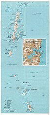
English: Map of the Nicobar and Andaman Islands. |
| 日期 | |
| 來源 | Courtesy of the University of Texas Libraries, The University of Texas at Austin. Reproduced from the Perry-Castañeda Library Map Collection of the University of Texas, Austin; originally from The Indian Ocean Atlas, produced and published (1976) by the U.S. Central Intelligence Agency. |
| 作者 | Pyramide~commonswiki |
| 授權許可 (重用此檔案) |
This material is in the public domain according to notes at Indian Ocean Maps and The UT Library Web Material Usage Statement |

|
File:Map of Nicobar and Andaman Islands-en.svg是本檔案的向量版本。 如果品質不低,就應該優先使用該檔案,而非JPG檔案。
File:Andaman nicobar 76.jpg → File:Map of Nicobar and Andaman Islands-en.svg
更多資訊請參閱Help:SVG/zh。 |
 |
授權條款
| 本圖像是中央情報局僱員的職務作品。作為美國聯邦政府的作品,本圖像或媒體屬於公有領域。
|

|
檔案歷史
點選日期/時間以檢視該時間的檔案版本。
| 日期/時間 | 縮圖 | 尺寸 | 用戶 | 備註 | |
|---|---|---|---|---|---|
| 目前 | 2004年12月26日 (日) 21:00 | | 894 × 2,068(315 KB) | Pyramide~commonswiki | Taken from that map site of Texas University and it says that CIA made it. It qualifies to teh rules stated at http://www.lib.utexas.edu/usage_statement.html |
檔案用途
全域檔案使用狀況
以下其他 wiki 使用了這個檔案:
- ar.wikipedia.org 的使用狀況
- ast.wikipedia.org 的使用狀況
- bcl.wikipedia.org 的使用狀況
- bg.wikipedia.org 的使用狀況
- bn.wikipedia.org 的使用狀況
- bn.wikiquote.org 的使用狀況
- ca.wikipedia.org 的使用狀況
- da.wikipedia.org 的使用狀況
- de.wikipedia.org 的使用狀況
- de.wikivoyage.org 的使用狀況
- en.wikipedia.org 的使用狀況
- eo.wikipedia.org 的使用狀況
- es.wikipedia.org 的使用狀況
- eu.wikipedia.org 的使用狀況
- fa.wikipedia.org 的使用狀況
- fi.wikipedia.org 的使用狀況
- fr.wikipedia.org 的使用狀況
- ga.wikipedia.org 的使用狀況
- hif.wikipedia.org 的使用狀況
- hu.wikipedia.org 的使用狀況
- id.wikipedia.org 的使用狀況
- incubator.wikimedia.org 的使用狀況
- ja.wikipedia.org 的使用狀況
- jv.wikipedia.org 的使用狀況
- kk.wikipedia.org 的使用狀況
- kn.wikipedia.org 的使用狀況
- ko.wikipedia.org 的使用狀況
- la.wikipedia.org 的使用狀況
- lt.wikipedia.org 的使用狀況
- mk.wikipedia.org 的使用狀況
- ml.wikipedia.org 的使用狀況
檢視此檔案的更多全域使用狀況。