File:Map-Germany-1945.svg
頁面內容不支援其他語言。
這個檔案來自維基共享資源
維基百科,自由的百科全書

原始檔案(SVG 檔案,表面大小:3,492 × 2,966 像素,檔案大小:726 KB)


摘要

描述
العربية: حدود المناطق المحتلة في ألمانيا عام 1957. الاراضي شرق خط نيس تحت السيطرة البولندية والسوفييتية، تظهر بلون ابيض. برلين منطقة مسيطر عليها من عدة بلدان داخل المنطقة السوفييتة.
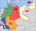
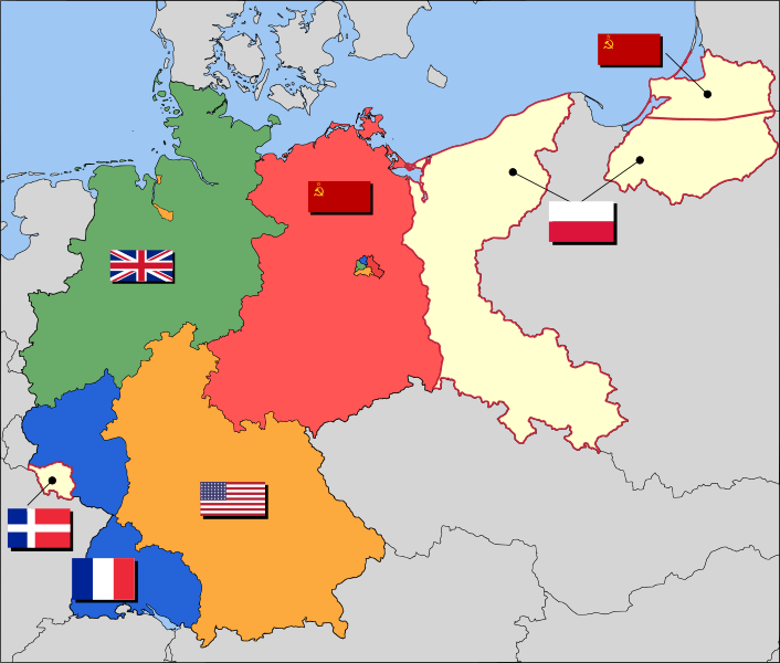
English: Occupation zone borders in Germany, 1947. The territories east of the Oder-Neisse line, under Polish and Soviet administration/annexation, are shown as cream as is the likewise detached Saar protectorate. Berlin is the multinational area within the Soviet zone.
Français : Carte des zones d'occupation de l'Allemagne : le protectorat français de la Sarre apparait en blanc-crème, comme la Silésie, la Poméranie et les autres régions allemandes orientales annexées par la Pologne et l'Union Soviétique.
Deutsch: Grenzen der Besatzungszonen in Deutschland, 1947. Die Gebiete östlich der Oder-Neiße-Grenze, unter polnischer und sowjetischer Verwaltung/Annexion, sowie das Saar-Protektorat sind cremefarben dargestellt. Berlin ist ein multinationales Gebiet inmitten der sowjetischen Besatzungszone.
日期 2008年三月17日 (原始上傳日期)
來源 Based on map data of the IEG-Maps project (Andreas Kunz, B. Johnen and Joachim Robert Moeschl: University of Mainz) - www.ieg-maps.uni-mainz.de.
作者 User:52 Pickup
SVG開發
InfoField
 
SVG檔案的原始碼無效,因為出現11個錯誤。
 
向量圖形使用Inkscape創作。

授權條款

w:zh:共享創意
姓名標示 相同方式分享
您可以自由:
  • 分享 – 複製、發佈和傳播本作品
  • 重新修改 – 創作演繹作品
惟需遵照下列條件:
  • 姓名標示 – 您必須指名出正確的製作者,和提供授權條款的連結,以及表示是否有對內容上做出變更。您可以用任何合理的方式來行動,但不得以任何方式表明授權條款是對您許可或是由您所使用。
  • 相同方式分享 – 如果您利用本素材進行再混合、轉換或創作,您必須基於如同原先的相同或兼容的條款,來分布您的貢獻成品。

原始上傳日誌

Transferred from en.wikipedia to Commons by Broadbeer using CommonsHelper.

The original description page was here. All following user names refer to en.wikipedia.
  • 2008-03-17 19:50 52 Pickup 3492×2966× (760290 bytes) Changes to fill and border colours. Made differences clearer between occupation zones and eventual territorial losses.
  • 2007-08-31 14:57 52 Pickup 3492×2966× (755561 bytes) New version: regions placed under Polish and Soviet administration now presented slightly differently (borders instead of colour fill), Saar colour now only slightly different to French zone (still needs some work)
  • 2007-08-10 09:50 52 Pickup 3492×2966× (751829 bytes) oops, now with fixed image size
  • 2007-08-10 09:47 52 Pickup 744×1052× (751774 bytes) {{Information| |Description= Germany in the aftermath of World War II: 1 September 1945 |Source= Based on map data of the IEG-Maps project (Andreas Kunz, B. Johnen and Joachim Robert Moeschl: University of Mainz) - [http://www.ieg-maps.uni-mainz.de www.ie
註解
InfoField
該圖片含有註解:在維基媒體共享資源上查看註解

說明

添加單行說明來描述出檔案所代表的內容
Occupation map of Germany after WW2

在此檔案描寫的項目

描繪內容

著作權狀態 繁體中文 (已轉換拼寫)

有著作權 繁體中文 (已轉換拼寫)

景文科技大學 繁體中文 (已轉換拼寫)

維基媒體項目關注列表 繁體中文 (已轉換拼寫)

1加2等於樂園 中文 (已轉換拼寫)

造物主泰勒 中文 (已轉換拼寫)

製作地點 中文 (已轉換拼寫)

十億位元組 繁體中文 (已轉換拼寫)

檔案歷史

點選日期/時間以檢視該時間的檔案版本。

日期/時間縮⁠圖尺寸用戶備⁠註
目前2017年12月1日 (五) 04:37於 2017年12月1日 (五) 04:37 版本的縮圖3,492 × 2,966(726 KB)SammimackUpdated flags and colours
2015年7月3日 (五) 14:13於 2015年7月3日 (五) 14:13 版本的縮圖3,492 × 2,966(728 KB)LichaoshengNew 48-Star US Flag from File:US flag 48 stars.svg
2015年7月3日 (五) 14:00於 2015年7月3日 (五) 14:00 版本的縮圖3,492 × 2,966(742 KB)LichaoshengReverted to version as of 18:46, 8 October 2008
2012年2月4日 (六) 15:19於 2012年2月4日 (六) 15:19 版本的縮圖3,492 × 2,966(742 KB)AnonMoosReverted to version as of 18:46, 8 October 2008 -- Kaliningrad had quite different status and fate from that of East Germany proper...
2012年1月20日 (五) 19:44於 2012年1月20日 (五) 19:44 版本的縮圖3,492 × 2,966(742 KB)Sammy pomponKaliningrado is occuped by USSR.
2008年10月8日 (三) 18:46於 2008年10月8日 (三) 18:46 版本的縮圖3,492 × 2,966(742 KB)File Upload Bot (Magnus Manske) {{BotMoveToCommons|en.wikipedia}} {{Information |Description={{en|Occupation zone borders in Germany, 1947. The territories east of the en:Oder-Neisse line, under Polish and Soviet administration/annexation, are shown as white as is the likewise det

全域檔案使用狀況

以下其他 wiki 使用了這個檔案:

檢視此檔案的更多全域使用狀況

詮釋資料