
File:Pima County Incorporated and Unincorporated areas Tortolita highlighted.svg

此 SVG 檔案的 PNG 預覽的大小:800 × 509 像素。 其他解析度:320 × 204 像素 | 640 × 407 像素 | 1,024 × 652 像素 | 1,280 × 815 像素 | 2,560 × 1,629 像素 | 1,100 × 700 像素。
原始檔案 (SVG 檔案,表面大小:1,100 × 700 像素,檔案大小:60 KB)
摘要
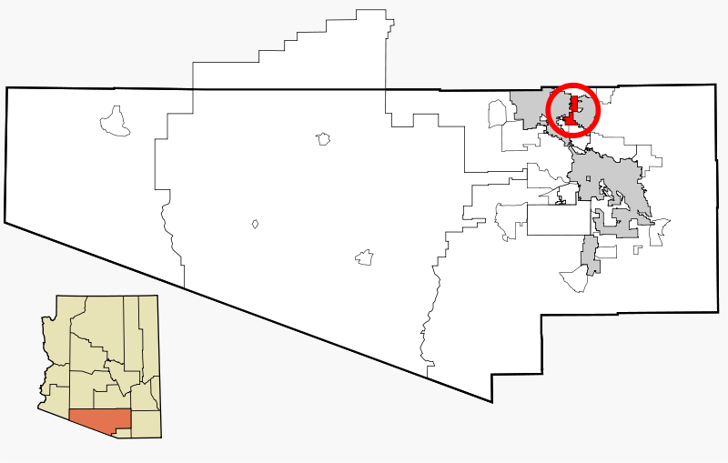
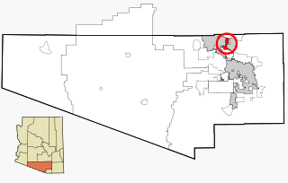
| 描述 | This map shows the incorporated areas and unincorporated areas in Pima County, Arizona. Incorporated cities are shown in gray and data for their borders and locations are based on the 2000/2030 PAG Transportation Analysis Zone Map. Tortolita is highlighted in red. Information for unincorporated locations and borders are based on the Census 2000 Pima County Tract Outline Index Map (PDF). I created this map in w:Inkscape. |
| 日期 | |
| 來源 | My own work, based on public domain information |
| 作者 | Ixnayonthetimmay |
| 授權許可 (重用此檔案) |
Copyleft-type licensing. See below. |
| 其他版本 | See Category:Maps of Pima County for other versions of this image. |
授權條款
| 我,此作品的版權所有人,釋出此作品至公共領域。此授權條款在全世界均適用。 這可能在某些國家不合法,如果是的話: 我授予任何人有權利使用此作品於任何用途,除受法律約束外,不受任何限制。 |
檔案歷史
點選日期/時間以檢視該時間的檔案版本。
| 日期/時間 | 縮圖 | 尺寸 | 用戶 | 備註 | |
|---|---|---|---|---|---|
| 目前 | 2007年2月23日 (五) 12:35 | | 1,100 × 700(60 KB) | Ixnayonthetimmay | {{Information |Description=This map shows the incorporated areas and unincorporated areas in Pima County, Arizona. Incorporated cities are shown in gray and data for |
檔案用途
下列頁面有用到此檔案:
全域檔案使用狀況
以下其他 wiki 使用了這個檔案:
- azb.wikipedia.org 的使用狀況
- ca.wikipedia.org 的使用狀況
- de.wikipedia.org 的使用狀況
- en.wikipedia.org 的使用狀況
- eu.wikipedia.org 的使用狀況
- fa.wikipedia.org 的使用狀況
- tt.wikipedia.org 的使用狀況
- uk.wikipedia.org 的使用狀況
- www.wikidata.org 的使用狀況