
File:Relief map Pacific Electric Railway.jpg

預覽大小:800 × 400 像素。 其他解析度:320 × 160 像素 | 640 × 320 像素 | 1,024 × 512 像素 | 1,280 × 640 像素 | 2,560 × 1,280 像素 | 6,432 × 3,216 像素。
原始檔案 (6,432 × 3,216 像素,檔案大小:9.25 MB,MIME 類型:image/jpeg)
摘要
| 描述 |
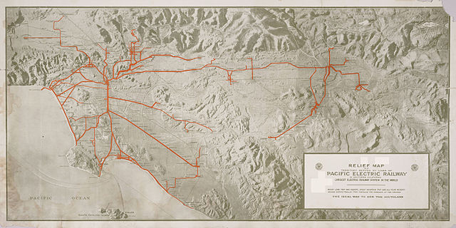
English: Relief map of territory served by lines of [the] Pacific Electric Railway in Southern California; largest electric railway system in the world
|
| 日期 | 約1920年 |
| 來源 | http://content.cdlib.org/ark:/13030/hb638nb72q/?layout=metadata |
| 作者 | Smith, O. A, Cartographer |
授權條款
此作品在美國屬於公有領域,因為其是由美國政府的官員或僱員,基於其個人公務目的製作的作品,參考美國法典第17篇第1章第105條。
注意︰本模板僅適用於美國聯邦政府的原創作品,不適用於任何美國州、屬地、聯邦個體、縣、市或任何次級政府的作品。本模板也不適用於1978年以後由美國郵政署出版的郵票圖案(參看美國版權局實踐綱領第313.6(C)(1)條)。也不適用於部分美國硬幣;參看美國鑄幣局使用條款。 |
 | |
| 此作品無已知的著作權限制,亦不受所有相關和鄰接的權利限制。 | ||
檔案歷史
點選日期/時間以檢視該時間的檔案版本。
| 日期/時間 | 縮圖 | 尺寸 | 用戶 | 備註 | |
|---|---|---|---|---|---|
| 目前 | 2014年9月3日 (三) 01:27 | | 6,432 × 3,216(9.25 MB) | Junkyardsparkle | Falling back to full/2 scale to unbreak thumbnail generation. |
| 2014年9月3日 (三) 01:08 |  | 12,864 × 6,432(18.79 MB) | Junkyardsparkle | Full resolution. | |
| 2014年8月27日 (三) 23:11 |  | 2,400 × 1,200(1.21 MB) | Junkyardsparkle | Higher resolution (names are legible at 1:1). | |
| 2007年6月24日 (日) 05:49 |  | 1,468 × 717(188 KB) | Nopira | from en:Image:Relief map Pacific Electric Railway.jpg http://ark.cdlib.org/ark:/13030/hb638nb72q/ Category:Los Angeles, California |
檔案用途
全域檔案使用狀況
以下其他 wiki 使用了這個檔案:
- en.wikipedia.org 的使用狀況
- fr.wikipedia.org 的使用狀況
- ja.wikipedia.org 的使用狀況
- simple.wikipedia.org 的使用狀況
- www.wikidata.org 的使用狀況