
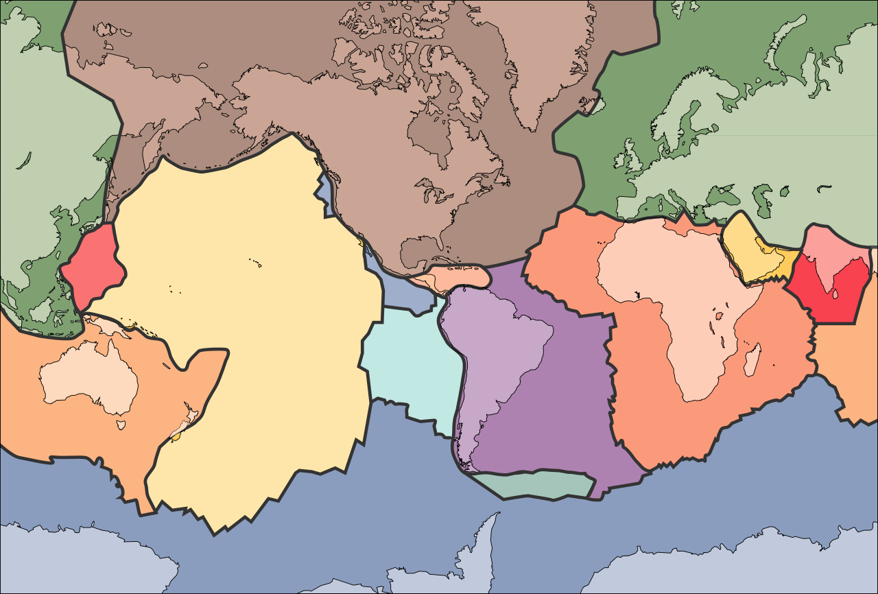
File:Tectonic plates (empty).svg

此 SVG 檔案的 PNG 預覽的大小:681 × 461 像素。 其他解析度:320 × 217 像素 | 640 × 433 像素 | 1,024 × 693 像素 | 1,280 × 866 像素 | 2,560 × 1,733 像素。
原始檔案 (SVG 檔案,表面大小:681 × 461 像素,檔案大小:356 KB)
الخلافه الرشيديهkp
摘要
| 描述 | |
| 日期 | 2005年九月10日 (上傳日期) |
| 來源 | File:Tectonic plates (empty).png |
| 作者 | Ævar Arnfjörð Bjarmason |
| 其他版本 |
本檔案衍生自: Tectonic plates (empty).png:
[]
|
| SVG開發 |


.png)


.svg?uselang=zh-hk)
.svg?uselang=zh-hk)
.svg?action=history&uselang=zh-hk)
.svg)
.png)
授權條款
|
|
檔案歷史
點選日期/時間以檢視該時間的檔案版本。
| 日期/時間 | 縮圖 | 尺寸 | 用戶 | 備註 | |
|---|---|---|---|---|---|
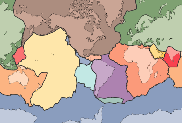
| 目前 | 2006年10月11日 (三) 02:04 | | 681 × 461(356 KB) | Sting | Borders correction integrated to the continents borders; size of picture |
| 2006年10月10日 (二) 16:29 |  | 682 × 462(285 KB) | Rogilbert~commonswiki | correction de frontières 2 | |
| 2006年10月10日 (二) 16:14 |  | 682 × 462(212 KB) | Rogilbert~commonswiki | correction des frontière | |
| 2005年9月10日 (六) 13:48 |  | 682 × 462(199 KB) | Ævar Arnfjörð Bjarmason | SVG version of Image:Tectonic plates (empty).png {{PD-USGov-USGS}} Category:Plate tectonics |
.png)
檔案用途
下列2個頁面有用到此檔案:
全域檔案使用狀況
以下其他 wiki 使用了這個檔案:
- ar.wikipedia.org 的使用狀況
- az.wikipedia.org 的使用狀況
- bn.wikipedia.org 的使用狀況
- en.wikipedia.org 的使用狀況
- Earth
- Internal structure of Earth
- Wikipedia:Graphics Lab/Image workshop/Archive/Jan 2009
- User:AvionArchon/sandbox
- User:Darth Tacker/TWA/Earth
- User:CheChe/Spoken Script
- User:Zanygenius/TWA/Earth
- User:Zanygenius/TWA/Earth/2
- User:Google7722/TWA/Earth
- Portal:Geophysics
- Portal:World
- User:FreshYoMama/TWA/Earth
- User:FreshYoMama/TWA/Earth/2
- en.wikiversity.org 的使用狀況
- eo.wikipedia.org 的使用狀況
- Kontinento
- Platotektoniko
- Litosfero
- Tektona plato
- Ŝablono:Tektonaj platoj
- Antarkta plato
- Eŭrazia plato
- Nordamerika plato
- Sudamerika plato
- Afrika plato
- Pacifika plato
- Hindia plato
- Aŭstralia plato
- Plato Nazca
- Anatolia plato
- Arabia plato
- Filipina plato
- Kokosa plato
- Karibia plato
- Plato Juan de Fuca
- Hind-Aŭstralia Plato
- es.wikipedia.org 的使用狀況
- fa.wikipedia.org 的使用狀況
- fr.wikipedia.org 的使用狀況
- gl.wikipedia.org 的使用狀況
- hu.wikipedia.org 的使用狀況
- id.wikipedia.org 的使用狀況
- io.wikipedia.org 的使用狀況
檢視此檔案的更多全域使用狀況。
.svg)
.svg)