
File:1820 Salem Massachusetts map bySaunders BPL 12094.png

預覽大小:800 × 541 像素。 其他解析度:320 × 216 像素 | 640 × 433 像素 | 1,052 × 711 像素。
原始檔案 (1,052 × 711 像素,檔案大小:1.2 MB,MIME 類型:image/png)
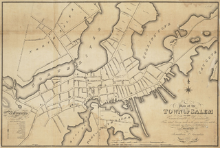
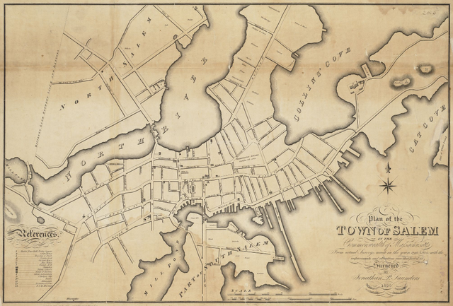
| 描述 | Plan of the town of Salem in the commonwealth of Massachusetts, from actual surveys, made in the years 1796 & 1804; with the improvements and alterations since that period as surveyed |
| 日期 | |
| 來源 | http://maps.bpl.org/details_12094 |
| 作者 | Saunders, Jonathan Peele |
|
|
 | |
 |
檔案歷史
點選日期/時間以檢視該時間的檔案版本。
| 日期/時間 | 縮圖 | 尺寸 | 用戶 | 備註 | |
|---|---|---|---|---|---|
| 目前 | 2011年2月15日 (二) 15:39 | | 1,052 × 711(1.2 MB) | M2545 | {{Information |Description=Plan of the town of Salem in the commonwealth of Massachusetts, from actual surveys, made in the years 1796 & 1804; with the improvements and alterations since that period as surveyed |Source=http://maps.bpl.org/details_12094 |D |
檔案用途
下列頁面有用到此檔案:
全域檔案使用狀況
以下其他 wiki 使用了這個檔案:
- be.wikipedia.org 的使用狀況
- de.wikipedia.org 的使用狀況
- en.wikipedia.org 的使用狀況
- Salem, Massachusetts
- Salem Harbor
- Nathaniel Bowditch House
- Nathaniel Hawthorne Birthplace
- Pickering House (Salem, Massachusetts)
- Crowninshield–Bentley House
- Salem Maritime National Historic Site
- Salem Hospital (Massachusetts)
- Quaker Meeting House (Peabody Essex Museum)
- Cotting–Smith Assembly House
- Andrew–Safford House
- Stephen Phillips House
- Hamilton Hall (Salem, Massachusetts)
- John Ward House (Salem, Massachusetts)
- Gardner–Pingree House
- Bridge Street Neck Historic District
- Charter Street Historic District
- Chestnut Street District
- City Hall (Salem, Massachusetts)
- Crombie Street District
- Derby Waterfront District
- Downtown Salem District
- Gedney and Cox Houses
- West Cogswell House
- Salem Common Historic District (Salem, Massachusetts)
- Phillips Library (Massachusetts)
- Timeline of Salem, Massachusetts
- Joseph Fenno House
- es.wikipedia.org 的使用狀況
- fr.wikipedia.org 的使用狀況
- hy.wikipedia.org 的使用狀況
- hyw.wikipedia.org 的使用狀況
- it.wikipedia.org 的使用狀況
- ja.wikipedia.org 的使用狀況
- kk.wikipedia.org 的使用狀況
- ky.wikipedia.org 的使用狀況
- lmo.wikipedia.org 的使用狀況
- mr.wikipedia.org 的使用狀況
- pl.wikipedia.org 的使用狀況
- pt.wikipedia.org 的使用狀況
- ro.wikipedia.org 的使用狀況
- ru.wikipedia.org 的使用狀況
- sh.wikipedia.org 的使用狀況
- sr.wikipedia.org 的使用狀況
- sv.wikipedia.org 的使用狀況
檢視此檔案的更多全域使用狀況。