
File:Cascadia earthquake sources.png
此為最大尺寸。
Cascadia_earthquake_sources.png (580 × 575 像素,檔案大小:25 KB,MIME 類型:image/png)
摘要
| 描述 |
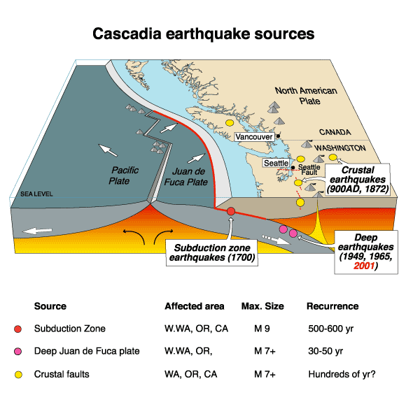
English: The Cascadia Earthquake. |
| 日期 | 2007年七月18日 (原始上傳日期) |
| 來源 | https://geomaps.wr.usgs.gov/pacnw/pacnweq/pdf/subd_eqpg.pdf |
| 作者 | Later versions were uploaded by Remember the dot at en.wikipedia. |
授權條款
|
|
原始上傳日誌
The original description page was here. All following user names refer to en.wikipedia.
- 2007-07-18 20:41 Remember the dot 580×575×8 (26101 bytes) removed border and US government markings
- 2007-07-18 20:38 PNG crusade bot 582×577×8 (27100 bytes) == Summary == The Cascadia Earthquake To replace an inferior-quality jpeg version of this file in Cascadia_earthquake.jpeg {{PD-USGov-Interior-USGS}} Got from [http://wrgis.wr.usgs.gov/wgmt/pacnw/pacnweq/casceq.html], a US government site (note: page moved, new address is http://geomaps.wr.usgs.gov/pacnw/pacnweq/casceq.html). =
Automatically converted to PNG
The PNG crusade bot automatically converted this image to the more efficient en:PNG format. The image was previously uploaded as "Cascadia earthquake.gif".
Previous file history
- 15:32:18, 28 April 2007 (UTC) . . Arg (Talk | contribs) . . 582x577 (35,329 bytes) (The Cascadia Earthquake To replace an inferior-quality jpeg version of this file in Cascadia_earthquake.jpeg Got from [http://wrgis.wr.usgs.gov/wgmt/pacnw/pacnweq/casceq.html], a US government site. )
Previous description history
- 18:04:58, 12 July 2007 (UTC) Remember the dot (Talk | contribs) (ShouldBePNG)
- 15:32:18, 28 April 2007 (UTC) Arg (Talk | contribs) (The Cascadia Earthquake To replace an inferior-quality jpeg version of this file in Cascadia_earthquake.jpeg Got from [http://wrgis.wr.usgs.gov/wgmt/pacnw/pacnweq/casceq.html], a US government site.)
檔案歷史
點選日期/時間以檢視該時間的檔案版本。
| 日期/時間 | 縮圖 | 尺寸 | 用戶 | 備註 | |
|---|---|---|---|---|---|
| 目前 | 2007年9月23日 (日) 16:24 | | 580 × 575(25 KB) | TCY | {{Information |Description=__NOTOC__ == Summary == The Cascadia Earthquake To replace an inferior-quality jpeg version of this file in Cascadia_earthquake.jpeg Got from [http://wrgis.wr.usgs.gov/wgmt/pacnw/pacnweq/casceq.html], a US government site. |
檔案用途
下列頁面有用到此檔案:
全域檔案使用狀況
以下其他 wiki 使用了這個檔案:
- ar.wikipedia.org 的使用狀況
- ca.wikipedia.org 的使用狀況
- cs.wikipedia.org 的使用狀況
- de.wikipedia.org 的使用狀況
- en.wikipedia.org 的使用狀況
- en.wikibooks.org 的使用狀況
- fr.wikipedia.org 的使用狀況
- it.wikipedia.org 的使用狀況
- ja.wikipedia.org 的使用狀況
- ko.wikipedia.org 的使用狀況
- mk.wikipedia.org 的使用狀況
- uk.wikipedia.org 的使用狀況
- vi.wikipedia.org 的使用狀況