
File:Roman provinces of Illyricum, Macedonia, Dacia, Moesia, Pannonia and Thracia.jpg

預覽大小:740 × 600 像素。 其他解析度:296 × 240 像素 | 592 × 480 像素 | 947 × 768 像素 | 1,263 × 1,024 像素 | 2,526 × 2,048 像素 | 2,817 × 2,284 像素。
原始檔案 (2,817 × 2,284 像素,檔案大小:1.41 MB,MIME 類型:image/jpeg)
| 描述 |
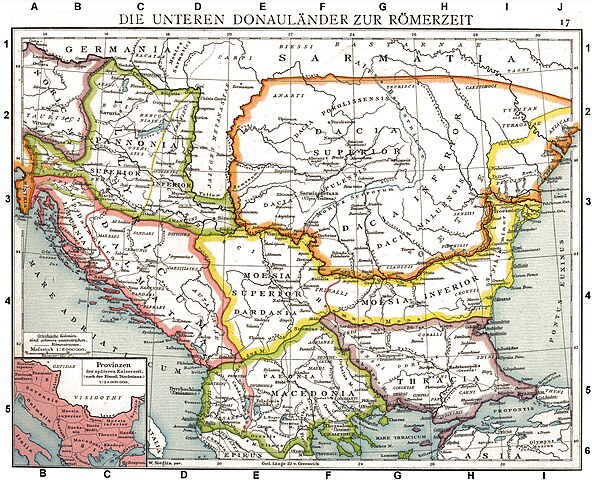
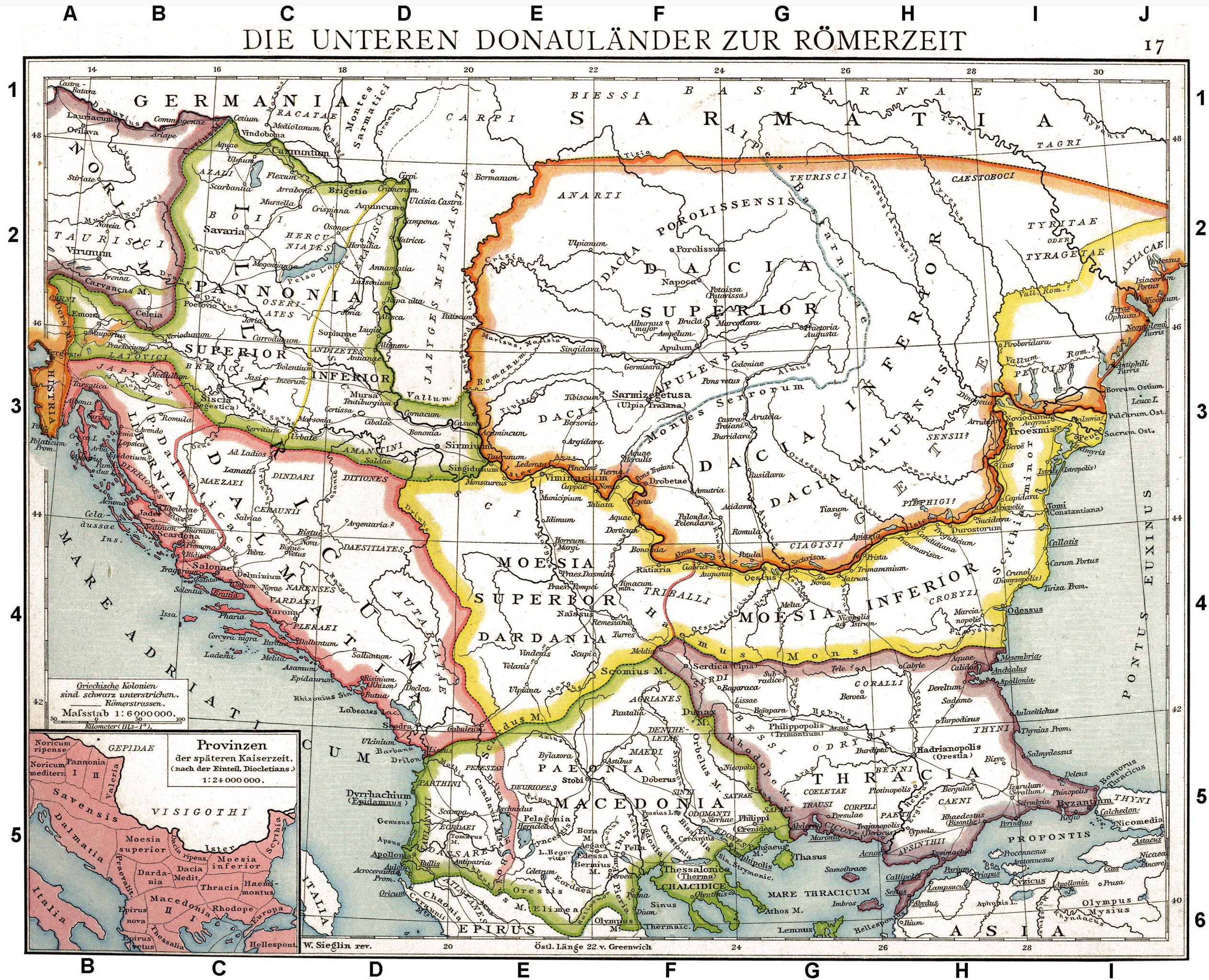
Deutsch: Die unteren Donauländer zur Römerzeit. Alte historische Karte aus Droysens Historischem Handatlas, 1886
English: The Roman provinces of the Lower Danube. Old historical map from Droysens Historical Atlas, 1886
Français : Provinces romaines d'Illyrie, de Macédoine, de Dacie, de Mésie, de Pannonie et de Thrace. Carte issue de l'Allgemeiner Historischer Handatlas de Gustav Droysen dirigé par Richard Andree, 1886. |
| 日期 | |
| 來源 | Allgemeiner historischer Handatlas in 96 Karten mit erläuterndem Text Bielefeld, Velhagen & Klasing 1886, S. 16. |
| 作者 | Gustav Droysen (1838 — 1908) |
| 其他版本 |
Derivative works of this file: |
.jpg)
|
本作品在其來源國以及其他版權期限是作者逝世後100年或以下的國家與地區屬於公有領域。 | |
| 此作品無已知的著作權限制,亦不受所有相關和鄰接的權利限制。 | |
|
公有領域作品必須在美國以及來源國沒有版權問題,才能上傳至維基共享資源。如果此作品不是美國作品,這個文件必須要有一個額外的版權標記顯示此文件在來源國的版權狀態。
注意:此標籤不應用於錄音作品。 |
| 註解 | 該圖片含有註解:在維基媒體共享資源上查看註解 |
檔案歷史
點選日期/時間以檢視該時間的檔案版本。
| 日期/時間 | 縮圖 | 尺寸 | 用戶 | 備註 | |
|---|---|---|---|---|---|
| 目前 | 2010年9月11日 (六) 10:06 | | 2,817 × 2,284(1.41 MB) | DIREKTOR | Repairs |
| 2008年5月27日 (二) 19:22 |  | 2,817 × 2,284(1.75 MB) | File Upload Bot (Magnus Manske) | {{BotMoveToCommons|en.wikipedia}} {{Information |Description={{en|Illyricum the Roman Province}} |Source=Transferred from [http://en.wikipedia.org en.wikipedia]; transfered to Commons by User:Koryakov Yuri using [http://tools.wikimedia.de/~magnus/com |
檔案用途
全域檔案使用狀況
以下其他 wiki 使用了這個檔案:
- als.wikipedia.org 的使用狀況
- an.wikipedia.org 的使用狀況
- ar.wikipedia.org 的使用狀況
- arz.wikipedia.org 的使用狀況
- ast.wikipedia.org 的使用狀況
- azb.wikipedia.org 的使用狀況
- az.wikipedia.org 的使用狀況
- be.wikipedia.org 的使用狀況
- bg.wikipedia.org 的使用狀況
- br.wikipedia.org 的使用狀況
- bs.wikipedia.org 的使用狀況
- ca.wikipedia.org 的使用狀況
- da.wikipedia.org 的使用狀況
- de.wikipedia.org 的使用狀況
- Thrakien (Landschaft)
- Geschichte Kroatiens
- Geschichte Sloweniens
- Illyrien
- Geschichte Ungarns
- Dalmatia
- Moesia
- Geschichte von Bosnien und Herzegowina
- Arad (Rumänien)
- Diskussion:Pannonia (Provinz)
- Pannonischer Aufstand
- Benutzer:Devil m25/Spielwiese
- Donaulimes
- Balkanromanische Sprachen
- Moesia inferior
- Via Militaris (Balkan)
- Diskussion:Serben/Archiv
- Biosphärenreservat Donaudelta
- Geschichte der Stadt Perg
- Taurisker
- Machland
檢視此檔案的更多全域使用狀況。