
File:Topographic map of Liberia-en.svg

此 SVG 檔案的 PNG 預覽的大小:799 × 600 像素。 其他解析度:320 × 240 像素 | 640 × 480 像素 | 1,023 × 768 像素 | 1,280 × 961 像素 | 2,560 × 1,922 像素 | 3,148 × 2,363 像素。
原始檔案 (SVG 檔案,表面大小:3,148 × 2,363 像素,檔案大小:1.69 MB)
摘要
| 描述 |
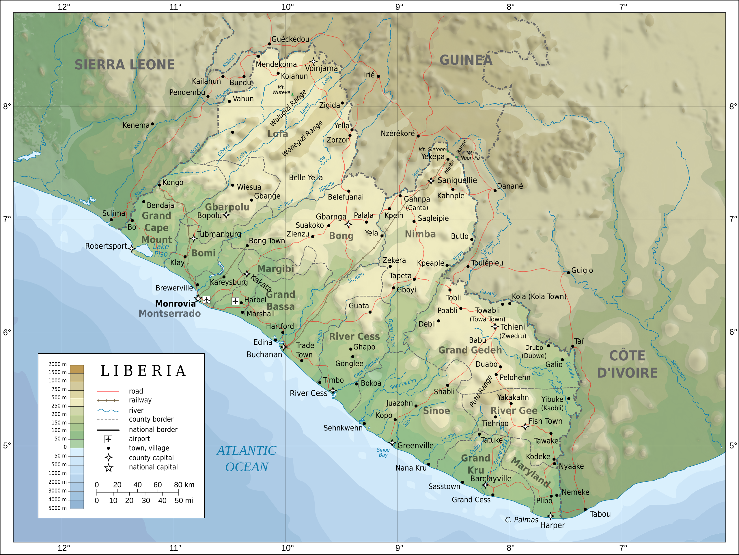
English: Topographic map of Liberia.
Français : Carte topographique du Liberia.
Suomi: Liberian topografinen kartta. |
| 日期 | |
| 來源 |
Self-made in Inkscape. Boundaries, rivers, roads, railroads, and place names based on a public domain United Nations map (Image:Un-liberia.png). Topography based on public domain GLOBE data from NOAA (http://www.ngdc.noaa.gov/mgg/topo/gltiles.html). Relief shading is an embedded PNG raster, derived from the GLOBE data using Perl. Bathymetry from NGDC ETOPO2. |
| 作者 | Oona Räisänen (Mysid) |
| 其他版本 |
Derivative works of this file: Railways in liberia-de.svg
|


|
This SVG file contains embedded text that can be translated into your language, using any capable SVG editor, text editor or the SVG Translate tool. For more information see: About translating SVG files. |
授權條款
我,本作品的著作權持有者,決定用以下授權條款發佈本作品:

|
已授權您依據自由軟體基金會發行的無固定段落、封面文字和封底文字GNU自由文件授權條款1.2版或任意後續版本,對本檔進行複製、傳播和/或修改。該協議的副本列在GNU自由文件授權條款中。 |
This file is licensed under the Creative Commons Attribution-Share Alike 4.0 International, 3.0 Unported, 2.5 Generic, 2.0 Generic and 1.0 Generic license.
- 您可以自由:
- 分享 – 複製、發佈和傳播本作品
- 重新修改 – 創作演繹作品
- 惟需遵照下列條件:
- 姓名標示 – 您必須指名出正確的製作者,和提供授權條款的連結,以及表示是否有對內容上做出變更。您可以用任何合理的方式來行動,但不得以任何方式表明授權條款是對您許可或是由您所使用。
- 相同方式分享 – 如果您利用本素材進行再混合、轉換或創作,您必須基於如同原先的相同或兼容的條款,來分布您的貢獻成品。
您可以選擇您需要的授權條款。
檔案歷史
點選日期/時間以檢視該時間的檔案版本。
| 日期/時間 | 縮圖 | 尺寸 | 用戶 | 備註 | |
|---|---|---|---|---|---|
| 目前 | 2010年7月31日 (六) 20:08 | | 3,148 × 2,363(1.69 MB) | Mysid | remove the false "dropoff" from land to sea in shading |
| 2010年7月31日 (六) 20:02 |  | 3,148 × 2,363(1.69 MB) | Mysid | fixed a couple of symbols + clipped the shading layer | |
| 2010年7月19日 (一) 10:49 |  | 3,148 × 2,363(2.64 MB) | Mysid | argh, forgot to update legend box | |
| 2010年7月19日 (一) 10:41 |  | 3,148 × 2,363(2.64 MB) | Mysid | revised for consistency with my other maps | |
| 2008年5月25日 (日) 12:46 |  | 3,148 × 2,363(2.87 MB) | Mysid | border in image; layers in XML | |
| 2008年5月12日 (一) 18:34 |  | 3,037 × 2,257(2.82 MB) | Mysid | adding lakes, airports, legends | |
| 2008年5月12日 (一) 16:44 |  | 3,037 × 2,257(2.81 MB) | Mysid | == {{int:filedesc}} == {{Information |Description= {{en|Topographic map of Liberia.}} {{fr|Carte topographique du Liberia.}} {{fi|Liberian topografinen kartta.}} |Source=Self-made in Inkscape.<br/>Boundaries |
檔案用途
下列3個頁面有用到此檔案:
全域檔案使用狀況
以下其他 wiki 使用了這個檔案:
- ar.wikipedia.org 的使用狀況
- az.wikipedia.org 的使用狀況
- bcl.wikipedia.org 的使用狀況
- be-tarask.wikipedia.org 的使用狀況
- be.wikipedia.org 的使用狀況
- bn.wikipedia.org 的使用狀況
- ca.wikipedia.org 的使用狀況
- ckb.wikipedia.org 的使用狀況
- de.wikipedia.org 的使用狀況
- el.wikipedia.org 的使用狀況
- en.wikipedia.org 的使用狀況
- eu.wikipedia.org 的使用狀況
- fa.wikipedia.org 的使用狀況
- fi.wikipedia.org 的使用狀況
- fr.wikipedia.org 的使用狀況
- hr.wiktionary.org 的使用狀況
- hu.wikipedia.org 的使用狀況
- hy.wikipedia.org 的使用狀況
- id.wikipedia.org 的使用狀況
- io.wikipedia.org 的使用狀況
- is.wikipedia.org 的使用狀況
- it.wikipedia.org 的使用狀況
- ka.wikipedia.org 的使用狀況
- lt.wikipedia.org 的使用狀況
- mzn.wikipedia.org 的使用狀況
- nds.wikipedia.org 的使用狀況
- nl.wikipedia.org 的使用狀況
- pl.wikipedia.org 的使用狀況
- ps.wikipedia.org 的使用狀況
檢視此檔案的更多全域使用狀況。