
File:Tropical Depression One 2009 GOES.jpg

預覽大小:800 × 600 像素。 其他解析度:320 × 240 像素 | 640 × 480 像素 | 1,024 × 768 像素 | 1,280 × 960 像素。
原始檔案 (1,280 × 960 像素,檔案大小:1,021 KB,MIME 類型:image/jpeg)
摘要
| 描述 |
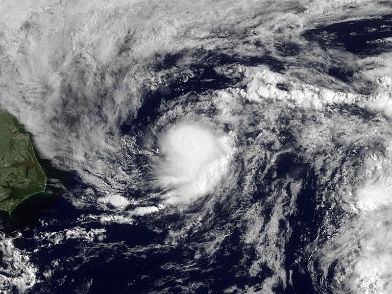
English: Shower activity has increased this morning in association with the area of low pressure located about 225 miles east-northeast of Cape Hatteras North Carolina. The low is currently moving to the northeast at 15 MPH along the relatively warm waters of the gulf stream. This system still has some potential to become a tropical cyclone over the next 12-24 hours but is not expected to threaten any land areas. |
| 日期 | |
| 來源 | http://www.nnvl.noaa.gov/MediaDetail.php?MediaID=210&MediaTypeID=1 |
| 作者 | NOAA; GOES |
| 授權許可 (重用此檔案) |
Public domain |
授權條款
本圖像屬於公有領域,因該作品最初來自於美國國家海洋和大氣管理局職員的職務作品。
|
檔案歷史
點選日期/時間以檢視該時間的檔案版本。
| 日期/時間 | 縮圖 | 尺寸 | 用戶 | 備註 | |
|---|---|---|---|---|---|
| 目前 | 2013年3月18日 (一) 20:27 | | 1,280 × 960(1,021 KB) | Supportstorm | Fix |
| 2010年5月14日 (五) 23:02 |  | 1,280 × 960(1,001 KB) | Supportstorm | Contrast Correction | |
| 2009年8月15日 (六) 20:09 |  | 1,280 × 960(886 KB) | Cyclonebiskit | {{Information |Description={{en|1=Shower activity has increased this morning in association with the area of low pressure located about 225 miles east-northeast of Cape Hatteras North Carolina. The low is currently moving to the northeast at 15 MPH along |
檔案用途
下列7個頁面有用到此檔案:
全域檔案使用狀況
以下其他 wiki 使用了這個檔案:
- bg.wikipedia.org 的使用狀況
- de.wikipedia.org 的使用狀況
- en.wikipedia.org 的使用狀況
- es.wikipedia.org 的使用狀況
- eu.wikipedia.org 的使用狀況
- fr.wikipedia.org 的使用狀況
- nl.wikipedia.org 的使用狀況
- pt.wikipedia.org 的使用狀況
- ru.wikipedia.org 的使用狀況