
File:Alexander archipelago.jpg

預覽大小:450 × 600 像素。 其他解析度:180 × 240 像素 | 360 × 480 像素 | 576 × 768 像素 | 1,050 × 1,400 像素。
原始檔案 (1,050 × 1,400 像素,檔案大小:529 KB,MIME 類型:image/jpeg)
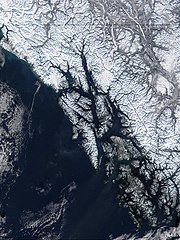
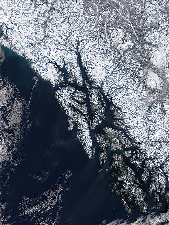
| 描述 | West of British Columbia, Canada, and south of the Yukon Territory, the southeastern coastline of Alaska trails off into the islands of the Alexander Archipelago. The area is rugged and contains many long, U-shaped, glaciated valleys, many of which terminate at tidewater. The Alexander Archipelago is home to Glacier Bay National Park. The large bay that has two forks on its northern end is Glacier Bay itself. The eastern fork is Muir inlet, into which runs the Muir glacier, named for the famous Scottish-born naturalist John Muir. Glacier Bay opens up into the Icy Strait. The large, solid white area to the west is Brady Icefield, which terminates at the southern end in Brady's Glacier. |
| 日期 | |
| 來源 | https://visibleearth.nasa.gov/images/57719/alexander-archipelago-southeastern-alaska |
| 作者 | Jacques Descloitres, MODIS Land Rapid Response Team, NASA/GSFC |
| 本作品由NASA創作,屬於公有領域。根據NASA的版權政策:“NASA的創作除非另有聲明否則不受版權保護。”(參見:Template:PD-USGov/zh,NASA版權政策或JPL圖像使用政策) | ||
 |
警告:
|
檔案歷史
點選日期/時間以檢視該時間的檔案版本。
| 日期/時間 | 縮圖 | 尺寸 | 使用者 | 備註 | |
|---|---|---|---|---|---|
| 目前 | 2005年6月1日 (三) 09:32 | | 1,050 × 1,400(529 KB) | Alib | NASA MODIS satellite image of the Alexander archipelago, Alaska |
檔案用途
下列頁面有用到此檔案:
全域檔案使用狀況
以下其他 wiki 使用了這個檔案:
- ar.wikipedia.org 的使用狀況
- arz.wikipedia.org 的使用狀況
- ast.wikipedia.org 的使用狀況
- az.wikipedia.org 的使用狀況
- be.wikipedia.org 的使用狀況
- ca.wikipedia.org 的使用狀況
- ceb.wikipedia.org 的使用狀況
- cs.wikipedia.org 的使用狀況
- da.wikipedia.org 的使用狀況
- de.wikipedia.org 的使用狀況
- en.wikipedia.org 的使用狀況
- en.wikivoyage.org 的使用狀況
- eo.wikipedia.org 的使用狀況
- es.wikipedia.org 的使用狀況
- et.wikipedia.org 的使用狀況
- eu.wikipedia.org 的使用狀況
- fa.wikipedia.org 的使用狀況
- fi.wikipedia.org 的使用狀況
- fr.wikipedia.org 的使用狀況
檢視此檔案的更多全域使用狀況。