
File:Former Yugoslavia 2008.PNG

預覽大小:800 × 527 像素。 其他解析度:320 × 211 像素 | 640 × 421 像素 | 1,024 × 674 像素 | 1,280 × 842 像素 | 1,887 × 1,242 像素。
原始檔案 (1,887 × 1,242 像素,檔案大小:114 KB,MIME 類型:image/png)

|
本圖片是以PNG、GIF或JPEG格式上傳。然而,其中包含的資料或訊息,應該重新建立成可縮放向量圖形(SVG)檔案,以更有效率或更準確的方式儲存。如有可能,請上傳本圖片的SVG格式版本。在上傳之後,請修改維基各姊妹計畫中所有使用舊版圖片的條目(列在圖像連結章節中),替換為新版圖片,並在舊圖片的描述頁中加入{{Vector version available|新圖片名稱.svg}}模板,同時移除本模板。
|
摘要
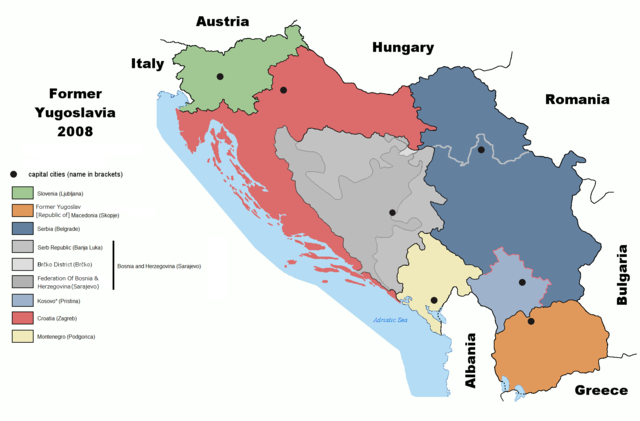
| 描述 |
English: Map of former Yugoslavia including Kosovo independence.
Deutsch: Karte des früheren Jugoslawiens einschließlich der Unabhängigkeit des Kosovo. |
| 日期 | |
| 來源 | derived from File:Former Yugoslavia 2006.png by Dudemanfellabra at en.wikipedia |
| 作者 | Ijanderson977 |
| 授權許可 (重用此檔案) |
Released under the GNU Free Documentation License. |
| 其他版本 |
|


Transferred from en:wikipedia to Commons by User:Tieum512 using CommonsHelper.
More versions on en.wikipedia see Original upload log below.
授權條款

|
已授權您依據自由軟體基金會發行的無固定段落、封面文字和封底文字GNU自由文件授權條款1.2版或任意後續版本,對本檔進行複製、傳播和/或修改。該協議的副本列在GNU自由文件授權條款中。 |
| 此檔案採用創用CC 姓名標示-相同方式分享 3.0 未在地化版本授權條款。 | ||
| ||
| 已新增授權條款標題至此檔案,作為GFDL授權更新的一部份。 |
原始上傳日誌
The original description page was here. All following user names refer to en.wikipedia.
- 2009-02-19 05:22 Српска Крајина 1887×1192× (131504 bytes)
- 2008-07-06 20:01 Ijanderson977 1887×1192× (130802 bytes) Corrected spelling from Albanian to English.
- 2008-07-04 00:35 Hoshie 1887×1192× (122315 bytes) Give Kosovo own color due to the change in status.
- 2008-03-18 23:43 Dudemanfellabra 1887×1192× (83000 bytes) Map of former Yugoslavia edited to include Kosovo independence. March 2008 Author: Floyd Maseda (Dudemanfellabra). Original image: [http://en.wikipedia.org/wiki/Image:Former_Yugoslavia_2006.png] June 2006 Author: Paweł Goleniowski (swPawel)
檔案歷史
點選日期/時間以檢視該時間的檔案版本。
| 日期/時間 | 縮圖 | 尺寸 | 使用者 | 備註 | |
|---|---|---|---|---|---|
| 目前 | 2022年10月26日 (三) 19:12 | | 1,887 × 1,242(114 KB) | Ghostantinos | fix |
| 2021年8月26日 (四) 21:06 |  | 1,887 × 1,242(105 KB) | Santasa99 | more npov | |
| 2019年7月27日 (六) 13:53 |  | 1,887 × 1,242(95 KB) | Drax90 | New updated version | |
| 2019年2月22日 (五) 19:05 |  | 1,887 × 1,192(136 KB) | Koreanovsky | Reverted to version as of 10:29, 21 February 2019 (UTC) | |
| 2019年2月21日 (四) 12:06 |  | 1,887 × 1,242(95 KB) | Drax90 | New color scheme | |
| 2019年2月21日 (四) 10:29 |  | 1,887 × 1,192(136 KB) | UglyGoat | Reverted to version as of 17:08, 4 February 2019 (UTC) | |
| 2019年2月12日 (二) 17:44 |  | 1,887 × 1,242(95 KB) | Drax90 | Fixed version of the map | |
| 2019年2月4日 (一) 17:08 |  | 1,887 × 1,192(136 KB) | Koreanovsky | There is no official border between Herzeg-Bosnia and FBiH; Reverted to version as of 23:01, 18 December 2011 (UTC) | |
| 2018年12月19日 (三) 16:52 |  | 1,887 × 1,242(97 KB) | Drax90 | Latest version with new colors | |
| 2018年11月24日 (六) 18:44 |  | 1,887 × 1,242(149 KB) | Drax90 | Updated version |
檔案用途
下列頁面有用到此檔案:
全域檔案使用狀況
以下其他 wiki 使用了這個檔案:
- ar.wikipedia.org 的使用狀況
- bg.wikipedia.org 的使用狀況
- ca.wikipedia.org 的使用狀況
- cs.wikipedia.org 的使用狀況
- de.wikipedia.org 的使用狀況
- de.wikibooks.org 的使用狀況
- el.wikipedia.org 的使用狀況
- en.wikipedia.org 的使用狀況
- es.wikipedia.org 的使用狀況
- eu.wikipedia.org 的使用狀況
- fr.wikipedia.org 的使用狀況
- gd.wikipedia.org 的使用狀況
- he.wikipedia.org 的使用狀況
- hyw.wikipedia.org 的使用狀況
- it.wikipedia.org 的使用狀況
- ja.wikipedia.org 的使用狀況
- kn.wikipedia.org 的使用狀況
- ko.wikipedia.org 的使用狀況
- lfn.wikipedia.org 的使用狀況
- mk.wikipedia.org 的使用狀況
- mr.wikipedia.org 的使用狀況
- nl.wikipedia.org 的使用狀況
- pnb.wikipedia.org 的使用狀況
- pt.wikipedia.org 的使用狀況
- rm.wikipedia.org 的使用狀況
- ro.wikipedia.org 的使用狀況
- ru.wikipedia.org 的使用狀況
- sh.wikipedia.org 的使用狀況
- sl.wikipedia.org 的使用狀況
- sr.wikipedia.org 的使用狀況
- te.wikipedia.org 的使用狀況
- th.wikipedia.org 的使用狀況
- tr.wikipedia.org 的使用狀況
- ur.wikipedia.org 的使用狀況
檢視此檔案的更多全域使用狀況。