
File:Heavy Snow in Eastern China.jpg

預覽大小:488 × 599 像素。 其他解析度:195 × 240 像素 | 391 × 480 像素 | 626 × 768 像素 | 834 × 1,024 像素 | 1,669 × 2,048 像素 | 4,400 × 5,400 像素。
原始檔案 (4,400 × 5,400 像素,檔案大小:5.47 MB,MIME 類型:image/jpeg)
摘要
| 描述 |
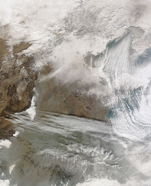
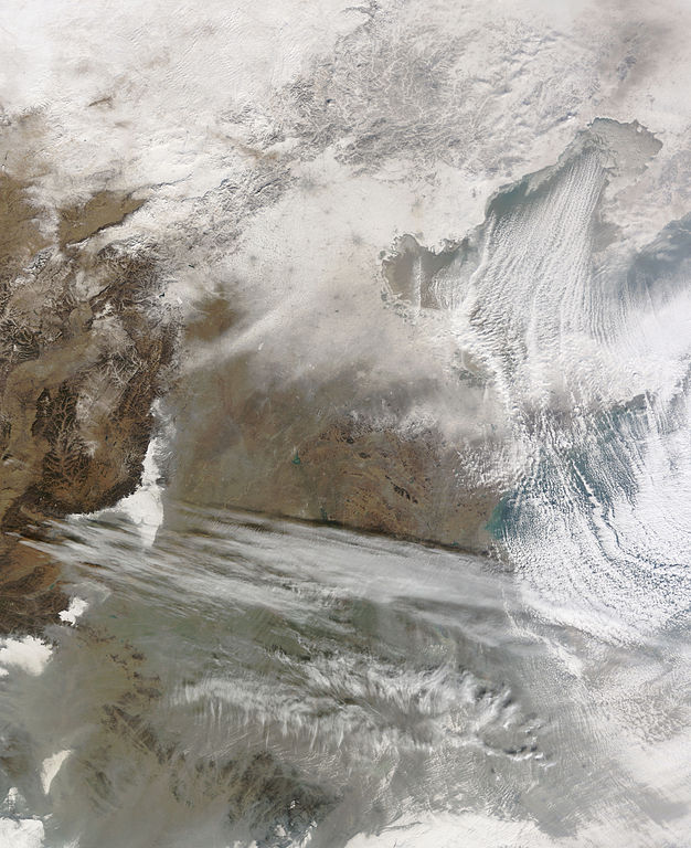
English: Snow cover encircles Bo Hai and extends to the north and west of that water body. Snow also covers Beijing, Tianjin, and a constellation of smaller settlements. The large cities leave big grey splotches on the blanket of snow, and the smaller cities make small grey dots. Snow caps the mountains north and west of Beijing, but the snow cover gradually fades south-west of Beijing and Tianjin. Cloud streets—clouds arranged in neat rows—similar to those observed over Hudson Bay and the Great Lakes float over Bo Hai. |
| 日期 | |
| 來源 | NASA Earth Observatory |
| 作者 | Jeff Schmaltz |
| 其他版本 |
|

Image captured by the Moderate Resolution Imaging Spectroradiometer (MODIS) on NASA’s Terra satellite, courtesy of the MODIS Rapid Response Team, Goddard Space Flight Centre.
授權條款
| 本作品由NASA創作,屬於公有領域。根據NASA的版權政策:“NASA的創作除非另有聲明否則不受版權保護。”(參見:Template:PD-USGov/zh,NASA版權政策或JPL圖像使用政策) | ||
 |
警告:
|
| 註解 | 該圖片含有註解:在維基媒體共享資源上查看註解 |
檔案歷史
點選日期/時間以檢視該時間的檔案版本。
| 日期/時間 | 縮圖 | 尺寸 | 使用者 | 備註 | |
|---|---|---|---|---|---|
| 目前 | 2010年1月7日 (四) 11:56 | | 4,400 × 5,400(5.47 MB) | Originalwana | {{Information |Description={{en|1=Snow cover encircles Bo Hai and extends to the north and west of that water body. Snow also covers Beijing, Tianjin, and a constellation of smaller settlements. The large cities leave big grey splotches on |
檔案用途
下列頁面有用到此檔案:
全域檔案使用狀況
以下其他 wiki 使用了這個檔案:
- ar.wikipedia.org 的使用狀況
- en.wikipedia.org 的使用狀況
- fa.wikipedia.org 的使用狀況
- ja.wikipedia.org 的使用狀況
- uk.wikipedia.org 的使用狀況
- www.wikidata.org 的使用狀況