
File:Tianjin, China ESA15420167.tiff

此TIF文件的JPG预览的大小:800 × 568像素。 其他分辨率:320 × 227像素 | 640 × 454像素 | 1,024 × 727像素 | 1,280 × 909像素 | 2,560 × 1,817像素 | 5,000 × 3,549像素。
原始文件 (5,000 × 3,549像素,文件大小:44.72 MB,MIME类型:image/tiff)
摘要
| 描述 |
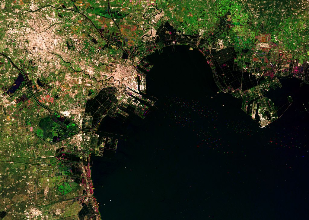
English: The Chinese city of Tianjin is captured in this Sentinel-1A radar image created by combining three scans over several months. The city sits to the west of the Bohai Bay within the Bohai Gulf, off of the Yellow Sea. With a population of over 14 million people, this megacity is among China’s five largest. Urban areas are home to over half of the world’s population, and are rapidly changing environments. As more people move from rural areas to cities, this growth needs to be monitored to help it proceed on a sustainable basis. High-resolution satellite data provide essential information for city planning and for the sustainable development of urban regions. Radar in particular can be used to monitor slight ground movements down to a few millimetres – valuable information for urban planners and for risk assessment. Zooming in on the upper right, we can see different colours in the geometric agricultural fields, showing changes between the three acquisitions (22 October 2014, 14 January 2015 and 7 February 2015) that make up this image. In this area, the black shapes show divided areas covered in water, which are possibly shrimp or fish farms. Bohai Bay was traditionally home to the country’s richest fisheries, but pollution, overfishing and land reclamation has diminished this economic activity. Farther south, we can see numerous dots in the water – radar reflections from the boats coming to and from the Port of Tianjin. This massive maritime gateway handles hundreds of millions of tonnes of cargo each year, and is the largest in northern China. On the central-left side of the image, the black and bright green areas are water reservoirs. The upcoming Sentinel-2 mission – set for launch on 22 June – will be used to support the sustainable management of water resources by providing measurements of water quality and detecting changes. This image is also featured on the Earth from Space video programme. |
| 日期 | 2015年6月5日 (上传日期) |
| 来源 | Tianjin, China |
| 作者 | European Space Agency |
| 其他版本 |
|
| Activity | Observing the Earth |
| Keyword | City Urban areas Radar Images |
| Location | China |
| Mission | Sentinel-1 |
| Set | Earth observation image of the week |
| System | Copernicus |

许可协议

|
此图像包含来自哥白尼计划中的卫星的数据,例如哨兵1号、哨兵2号或哨兵3号。使用此图片时需要注明出处。
署名: 包含修改后的哥白尼哨兵数据2014/2015
哥白尼哨兵数据的使用受欧盟法律监管(委员会授权条例 (EU) No 1159/2013和条例 (EU) No 377/2014)。相关摘录:
应免费访问通过GMES传播平台提供的GMES专用数据[...]。
在合法的范围内应出于以下用途的目的访问GMES专用数据[...]:
GMES专用数据[...]可在全球范围内不受时间限制地使用。
向用户提供GMES专用数据和GMES服务信息没有任何明示或暗示的保证,包括关于质量和任何目的的适用性。 |
This media was created by the European Space Agency (ESA).
Where expressly so stated, images or videos are covered by the Creative Commons Attribution-ShareAlike 3.0 IGO (CC BY-SA 3.0 IGO) licence, ESA being an Intergovernmental Organisation (IGO), as defined by the CC BY-SA 3.0 IGO licence. The user is allowed under the terms and conditions of the CC BY-SA 3.0 IGO license to Reproduce, Distribute and Publicly Perform the ESA images and videos released under CC BY-SA 3.0 IGO licence and the Adaptations thereof, without further explicit permission being necessary, for as long as the user complies with the conditions and restrictions set forth in the CC BY-SA 3.0 IGO licence, these including that:
See the ESA Creative Commons copyright notice for complete information, and this article for additional details.
|
 | |
本文件采用知识共享署名-相同方式共享 3.0 政府间组织许可协议授权。 署名: ESA, CC BY-SA IGO 3.0
| ||
文件历史
点击某个日期/时间查看对应时刻的文件。
| 日期/时间 | 缩略图 | 大小 | 用户 | 备注 | |
|---|---|---|---|---|---|
| 当前 | 2020年6月11日 (四) 21:09 |  | 5,000 × 3,549(44.72 MB) | OptimusPrimeBot | #Spacemedia - Upload of https://esamultimedia.esa.int/img/2015/06/Tianjin_S1A_IW_GRDH_1SSV_multitemporal_jan2015_oct2014_feb2015_subset.tif via Commons:Spacemedia |
文件用途
以下页面使用本文件:
全域文件用途
以下其他wiki使用此文件:
- hy.wikipedia.org上的用途