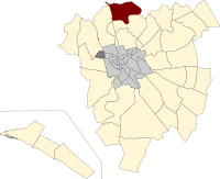
托迪昆托
外觀
| 托迪昆托 | |
|---|---|
 | |
 在羅馬市的位置 | |
| 坐標:41°56′43″N 12°28′37″E / 41.94519°N 12.47698°E | |
| 國家 | 意大利 |
| 大區 | 拉齊奧大區 |
| 省 | 羅馬 |
| 市鎮 | 羅馬 |
| 成立 | 1954年3月1日 |
| 面積 | |
| • 總計 | 4.89 平方公里(1.89 平方英里) |
| 時區 | CET(UTC+1) |
| • 夏時制 | CEST(UTC+2) |
托迪昆托(Q. XVIII Tor di Quinto)是意大利羅馬的第 18新城分區,由首字母Q. XVIII標識。
地理[編輯]
托迪昆托的北面與托迪昆托郊區分區 (S. I) [1]和格羅塔羅薩鄉村分區 (Z. LVI) 接壤。 [2]
東面與瓦爾梅萊納鄉村分區 (Z. I) 接壤。 [3]
西面與 德拉維多利亞 新城分區(Q. XV) 接壤。 [5]
教堂[編輯]
參考[編輯]
- Municipio Roma XV. Roma Capitale. [2023-04-12]. (原始內容存檔於2020-01-15).
- ^ Separated from the Acquatraversa ditch, in the stretch from via Cassia height via dell'Acqua Traversa 41°57′10″N 12°27′24″E / 41.952886°N 12.456781°E to via dei Due Ponti.
- ^ Separated from the rivolo dell'Aniene, from via Flaminia Vecchia junction via dei Due Ponti until it enters the Tiber river.
- ^ Separated from the Tiber river, by the introduction of the rivulet of the Aniene 41°57′14″N 12°29′23″E / 41.953941°N 12.489703°E until the river enters Aniene.
- ^ Separated from the Tiber river, from the entrance of the Aniene river to Ponte Milvio.
- ^ Separated from via Cassia, in the stretch from the Milvio bridge (Tiber) to via della Camilluccia.
