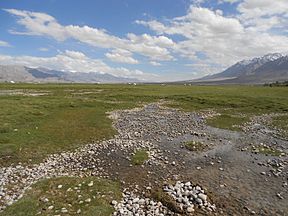
塔格敦巴什帕米爾
| 塔格敦巴什帕米爾 | |
|---|---|
| 塔克敦巴什帕米爾 塔什庫爾干河谷 | |
 | |
| 地理 | |
| 位置 | 中國 新疆 塔什庫爾干塔吉克自治縣 |
| 人口中心 | 塔什庫爾干鎮 & 達布達爾鄉 |
| 坐標 | 37°12′N 75°24′E / 37.200°N 75.400°E |
| 道路 | 喀喇崑崙公路 |
塔格敦巴什帕米爾、塔克敦巴什帕米爾或歷史上的塔德八士[1],現在的塔什庫爾干河谷[2]是帕米爾高原河谷[3],位於中國新疆塔什庫爾干塔吉克自治縣西南部,在喀喇崑崙公路以西。居住着瓦罕族、柯爾克孜族和薩雷闊勒族牧民,他們在帕米爾草原上放牧氂牛其他動物[4]。
塔格敦巴什帕米爾這個名字有時也用於帕米爾周圍的山脈,在巴基斯坦、阿富汗和塔吉克斯坦 與中國的邊界上,橫跨帕米爾高原沿着薩雷闊勒嶺、興都庫什山脈、慕士塔格峰和瓦罕。該山脈將阿富汗的巴達赫尚省、塔吉克斯坦的山地巴達赫尚自治州和巴基斯坦的吉爾吉特-巴爾蒂斯坦 分隔開。
在清朝期間,中國人聲稱對該地區擁有宗主權,但允許坎巨提的罕薩米爾管理該地區作為對中國朝貢回報[5] 。據英國殖民地消息來源稱,這種安排始於早期阿約什王朝(Ayosh)的罕薩米爾,隨着罕薩米爾統治者征服了塔格敦巴什帕米爾的柯爾克孜游牧民族[6]。罕薩米爾統治者在達布達爾鄉豎立了一座石標以證明他的控制權。朝貢制度一直持續到1937年[4][5]。
1984年,帕米爾及周邊地區被劃為塔什庫爾干野生動物自然保護區[2]。卡拉其古河谷 ,位於塔什庫爾干河谷的分支是中國唯一可以找到馬可波羅盤羊的地方[7]。
參考文獻[編輯]
- ^ Ministry of Foreign Affairs (Taiwan). 外交部档案丛书: 界务类 [Ministry of Foreign Affairs Archives: Boundary Affairs]. 外交部. 2001: 54. ISBN 978-957-02-9381-4.
...塔德八士兩地繼續與喀什噶爾之中國當局保持禮物之交換 / Taghdumbash to continue maintain tribute exchange with Chinese authorities at Kashgar
- ^ 2.0 2.1 Taxkorgan Nature Reserve. icimod.org. 國際山地綜合發展中心. [2017-02-05]. (原始內容存檔於2016-08-12).
Basically flat and in places more than 5km wide, the Taxkorgan Valley (the Taghdumbash Pamir on old maps) was part of the ancient Silk Route
- ^ Stein, M. Aurel. Ancient Khotan: Detailed Report of Archaeological Explorations in Chinese Turkestan 1. Oxford, UK: 牛津大學出版社. 1907: 32.
That part of the valley which properly bears the designation of Taghdumbash Pamir may be said to extend from the Wakhjir Pass to a short distance above Dafdar
- ^ 4.0 4.1 Wiener, Gerald; Han, Jianlin; Long, Huijun. Yak keeping in Western High Asia: Tajikistan, Afghanistan, Southern Xinjiang Pakistan, by Hermann Kreutzmann. The Yak 2nd. Bangkok: FAO RAP. June 2003 [2023-01-28]. ISBN 9251049653. (原始內容存檔於2019-02-17).
- ^ 5.0 5.1 Christopher Snedden. Understanding Kashmir and Kashmiris. Oxford University Press. 2015: 119. ISBN 978-1-84904-342-7.
For 200 years, the Mir of Hunza had paid tribute annually to officials of China's Qing/Manchu dynasty located in Kashgar. .. the Mir may have received tribute from a lesser ruler in the Taghdumbash Pamir north of Hunza. Although the Mir of Hunza eventually accepted Dogra suzerainty, the British only forced him to end his tributary relationship with China in 1937
- ^ Ayaz, Muhammad. Gazetteer of Gilgit. Simla Government of India Press 2nd (Simla: Government of India Press). 1927: 85 [2023-01-28]. (原始內容存檔於2022-09-30).
In former days Salim Khan, son of Ayasho and ruler of Hunza, marched against the Kirghiz nomads of the Taghdumash Pamir, and in the battle that ensued utterly routed them. In celebration of his victory he erected a cairn of stones at Dafdar, and sent a trophy of Kirghiz heads as present to the Chinese, together with a message that Hunza territory extended as far as Dafdar. Although hitherto Humza had held no intercourse of any kind with the Chinese, the latter returned a present to Salim Khan for having conquered their enemies, and henceforward a custom of an annual interchange of presents between the Chinese and the people of Hunza has prevailed to this day. Hunza has also drawn a yearly tribute in the form of a grazing tax, from all, whether Kirghiz or Sarikuli, who graze in the Taghdumbash.
- ^ USFWS. Endangered and Threatened Wildlife and Plants; Proposed Threatened Status for Argali (PDF). Federal Register (USDOI). 1990-10-05 [2017-02-05]. (原始內容 (PDF)存檔於2017-02-25).
consisting of fewer than 150 animals, was confined to the western part of the Chalachigu Valley, a finger of land extending between Afghanistan on the north and Pakistan to the south.
外部連結[編輯]
- Holdich, Thomas Hungerford. Pamirs. Encyclopædia Britannica 20 (第11版). London: 655–659. 1911.
| 這是一篇與新疆相關小作品。你可以透過編輯或修訂擴充其內容。 |


