
File:Aerial view looking down at Manhattan Tower. Jet Lowe, photographer, 1982. - Brooklyn Bridge, Spanning East River between Park Row, Manhattan and Sands Street, Brooklyn, New York HAER NY,31-NEYO,90-37.tif

此TIF文件的JPG预览的大小:738 × 599像素。 其他分辨率:296 × 240像素 | 591 × 480像素 | 946 × 768像素 | 1,261 × 1,024像素 | 2,522 × 2,048像素 | 4,665 × 3,789像素。
原始文件 (4,665 × 3,789像素,文件大小:16.86 MB,MIME类型:image/tiff)
摘要
| Aerial view looking down at Manhattan Tower. Jet Lowe, photographer, 1982. - Brooklyn Bridge, Spanning East River between Park Row, Manhattan and Sands Street, Brooklyn, New York, New York County, NY
( |
||||||||||||||||||||||||
|---|---|---|---|---|---|---|---|---|---|---|---|---|---|---|---|---|---|---|---|---|---|---|---|---|
| 摄影师 |
Related names:
|
|||||||||||||||||||||||
| 标题 |
Aerial view looking down at Manhattan Tower. Jet Lowe, photographer, 1982. - Brooklyn Bridge, Spanning East River between Park Row, Manhattan and Sands Street, Brooklyn, New York, New York County, NY |
|||||||||||||||||||||||
| 描绘地点 | New York; New York County; New York | |||||||||||||||||||||||
| 日期 | 1982年 | |||||||||||||||||||||||
| 尺寸 | 高度:4英寸(10.1厘米);宽度:5英寸(12.7厘米) | |||||||||||||||||||||||
| 现存地点 |
Library of Congress Prints and Photographs Division Washington, D.C. 20540 USA http://hdl.loc.gov/loc.pnp/pp.print |
|||||||||||||||||||||||
| 登录号 |
HAER NY,31-NEYO,90-37 |
|||||||||||||||||||||||
| 荣誉行 |
|
|||||||||||||||||||||||
| 备注 |
|
|||||||||||||||||||||||
| 参考 |
|
|||||||||||||||||||||||
| 来源 | https://www.loc.gov/pictures/item/ny1234.photos.120527p | |||||||||||||||||||||||
| 授权 (二次使用本文件) |
|
|||||||||||||||||||||||
.jpg)

| 物体位置 | | 在以下服务上查看本图像和附近其他图像: OpenStreetMap |
|---|
文件历史
点击某个日期/时间查看对应时刻的文件。
| 日期/时间 | 缩略图 | 大小 | 用户 | 备注 | |
|---|---|---|---|---|---|
| 当前 | 2014年7月29日 (二) 15:14 | 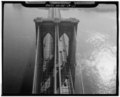 | 4,665 × 3,789(16.86 MB) | Fæ | GWToolset: Creating mediafile for Fæ. HABS 24 July 2014 (2301:2600) |
文件用途
以下页面使用本文件: