
加萊拉港
| Puerto Galera | |
|---|---|
| 基層政權 | |
 沙璜灣 | |
 | |
.svg) Puerto Galera 加萊拉港的位置 | |
| 坐标:13°30′00″N 120°57′15″E / 13.5°N 120.95417°E | |
| 國家 | 菲律賓 |
| 區 | 民馬羅巴區(Region IV-B) |
| 省 | 東民都洛省 |
| Founded | 1574年 |
| 政府[1] | |
| • 市長 | Hubbert C. A. Dolor |
| 面积[2] | |
| • 总计 | 247.85 平方公里(95.70 平方英里) |
| 人口(2010)[3] | |
| • 總計 | 32,521人 |
| • 密度 | 131人/平方公里(340人/平方英里) |
| 时区 | PST(UTC+8) |
| 郵區編號 | 5203 |
| 電話區號 | 43 |
| 網站 | www.puertogalera.gov.ph |
加萊拉港(英語:Puerto Galera,又称:海豚湾),位於菲律賓東民都洛省最西北方的一個地區,距離首府馬尼拉大約130公里(81英里),以旅遊業最為出名,當地的沙璜灣(Sabang Bay)自1973年已被聯合國教科文組織列為人與生物圈保護區(Man and Biosphere Reserve),擁有全亞洲最多樣化的珊瑚礁,是區內知名的潛水勝地。當地的性產業亦都惡名昭彰,伴遊小姐到處皆是,專門向單身男子兜搭,每逢入夜戈戈舞酒吧更加其門如市,十足紅燈區一樣。
圖片集[编辑]
-
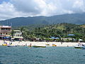 白灘
白灘 -
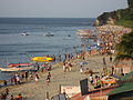 白灘
白灘 -
 塔玛拉瀑布
塔玛拉瀑布 -
 1917年繪製的航海圖


參考[编辑]
- ^ Official City/Municipal 2013 Election Results. Intramuros, Manila, Philippines: Commission on Elections (COMELEC). 11 September 2013 [23 December 2013]. (原始内容存档于2014-01-25).
- ^ Province: ORIENTAL MINDORO. PSGC Interactive. Makati City, Philippines: National Statistical Coordination Board. [30 October 2012]. (原始内容存档于2012年11月14日).
- ^ Total Population by Province, City, Municipality and Barangay: as of May 1, 2010 (PDF). 2010 Census of Population and Housing. National Statistics Office. [30 October 2012]. (原始内容存档 (PDF)于2012-11-15).